Tsunami

Crescent City harbor has a history of damage from tsunami's.

This event also caused concern. We had a series of tiny waves come in this time causing no damage.

A couple years ago we had another small wave and it did do damage in the harbor. In fact many of the docks are still not being used because of the damage.

Of course for us the real tsunami damage came in 1964 from the Alaska quake.

When I see the water departing, I am heading to high grounds. If I were on my boat I doubt if I would know about it till I came back in.

Scary stuff, have a escape route and listen for the tsunami warning. The tsunami that last damaged the harbor had created a mass exodus from town. It was crazy how people were driving, especially my wife. I saw the mess and went back to the house as it sits well above the flood zone for the small ones.

How do you escape a volcanic eruption if you live near Yellow stone? Now that seems really scary.
 
In geologic hazards, we divide them into two types: those that are predictions based on mounting data and those that are 'for sure' based on data.

I've attended meetings by geologists and public officials concerned about issuing 'warnings.' The decision at the last national meeting I attended was we would issue warnings for the type two forecasts - 'for sure' events coming, based on hard data. And not, for those that were concerned with a 'potential' hazard from an event.

In other words, a tsunami warning (the result of an earthquake well documented) would always be issued - and if the tsunami itself was recorded by sensors the warnings would be insistent and give a precise time of arrival if possible.

On the other hand, increasing movement by lava detected underground under a volcano, or an increase in micro tremors under the volcano, would not result in a warning. Whether there would be an eruption could not be given 100% probability and the precise timing would be impossible to predict.

The same with earthquake prediction - stress is constantly being measured across most active fault zones - but predicting the exact time of rupture is usually not possible, so warnings are not issued even with an abrupt increase in stress recorded.

The dire results of panic, after the issuing of a warning, can easily result in fatalities and large property loss - and what, then, if the event does not occur?

So we decided that 'sure thing' events (like most tsunamis) would be predicted and warnings given.

But for probable events, we would only release info about increased activity so folks could prepare for evacuation, but not issue a 'warning' for the event. We might term our concerns as a 'watch' or 'advisory' but not a warning. This is what happened at Mt. St. Helens. Folks were told things were heating up, and it might be wise to pack up and move out for awhile, but no prediction of time of event was given (it wasn't known). Some, like Harry Truman and his 16 cats, decided to stay and were killed.

A neighbor of ours once told us - "Good to have a geologist associated with hazard prediction as a neighbor. If we see you guys suddenly packing up the kids and clearing out of town, we'll do the same - knowing you know of some possible dire geologic event and can't tell anyone."
 
I think that it is interesting that some boats were able to get away from the dock and survive the Tsunami, others both at anchor and at the dock were thrown onto the land. The harbor is fairly deep even up in the harbor--24 to 30 fathoms in the center. The harbor is also the type where Tsunami's will cause massive damage on the shore, because it is long, deep and relitatively narrow.

The boats which survived (for the most part) were those which got away from the dock on the first wave, or during the recession preceeding the first wave.

I have been aboard several times when there were earth quakes, and it feels like some thing has shaken the boat. It is a different feeling than you experience on land. In each case, I either slipped mooring lines or hoisted the anchor and put to sea.

I suspect that if one avoided debris in the relitatively deep harbor of Pago Pago, that the boat would ride the Tsunami out. If you were anchored in shoal water, that would be the end, as the wave came in. The moral seems to be if you think there is an earth quake, and you are in a harbor which is susceptable, get out when the quake happens. The exception of course is if you are some distance from the boat--and in that case, head for high ground.
 
This is an interesting new site from Woods Hole Oceanographic on tsunamis - and what to do to prepare and protect from them.

http://www.whoi.edu/home/interactive/tsunami/

I recently posted a site showing the geologic hazard maps prepared for the state of Oregon - that site shows the areas most vulnerable to tsunamis, and coupled with this site from Woods Hole should give you coastal Oregonians all the knowledge necessary to cope with a possible tsunami.

But a reminder - we are boaters on this site, most of us coastal salt water boaters, and all of our coasts are vulnerable so knowledge regarding tsunamis can be important to you and your families - so this information from Woods Hole is valuable to all of us.

Oh and while we're on the subject of geological hazards - for you coastal Washingtonians (and to a somewhat lesser degree, Oregonians)- some recent geological studies have indicated that the seismological hazard in your area is considerably greater than previously thought. Your earthquake risk has been known to be high - but now even that risk has been elevated.

Of course the precise timing of an earthquake is beyond our present geological ability - but we're pretty good at defining areas of greatest hazard so for residents of those areas - being prepared and knowing how to respond is prudent.

-- from your 'resident' geologist
 
Bill and El,

Thanks for the interesting links. the PNW is a special area and even with the chance of earthquakes, tsunami's and volcanoes, for me it beats 'gaters bugs and snakes, or heat and humidity. Elvis was right, we might be "all shook up" yet.

Happy New Year, :D

Harvey
SleepyC :moon
 
Yeah it was a roller. It felt like someone was trying to push over my shed. I was target shooting. Still confused, I looked over at the boat and it was bouncing on the trailer. Then I realized it was an earth quake.

I was high and dry and decided not to go check out the surf. Wife called from work to check on things and then her son called from Bend because he heard Crescent City was being evacuated. I told him I never heard the siren, then went thru a drive thru to get some food.

Point looks surfable, around 8 guys on it, a few crab boats were heading to the harbor thru dragon straits and tomorrow we should have high winds to provide some board time. Crescent City rocks!
 
There were tsunami alerts sent out after the horrific earthquake in Haiti, but apparently the ocean sensors only reported small waves - local effects have not been reported yet due to the devastation of the city.

There have been almost fifty aftershocks reported as of now, many large enough to collapse weakened buildings. The views we are beginning to see of the disaster could as easily be from our US west coast, Alaska, or other areas in the US.

It is a reminder for us to who live in vulnerable geologic terranes to know the threats, recognize the initial signs, know instinctively what to do (having pre-thought a suitable response), and having an 'emergency kit' (like we carry on our boats) at the ready with emergency shelter, food, and first aid.
 
Bill (as always) makes an excellent point. You need to have a "bug out kit" since you never know when diseaster will strike. This weekend a very nice beach front burned to the ground in less than 30 minutes. The owner was an ex Blue Angel pilot, and hopefully he had a kit packed (since he is also in hurricane severe threat zone). We always keep our computers backed up with portable hard drives, at least a days worth of clothes ready to go, and simple first aid kit, along with water. When we lived in S. Calif. We always had the "earth quake kit" in the car, and that included a sleeping bag, some pry bars and small sledge hammers, as well as the clothes and emergency gear. Another cruitial issue is to have both a credit card and cash ready in the emergnecy kit, so you can grab it in an instant. We have always had the mantra of being able to survive independently for at least 3 days, from the emergency supplies. Of course these folks will have a much longer time to get any real services up and running.

Such a devistating event, on top of extreme poverity. I have heard figures of 100,000 dead bantered about.

Thanks for the reminder and prayers for the victums and rescue workers!
 
An update on the Eureka quake.

There was no tsunami from this one, and there was damage. Fortunately no deaths.

Eureka has damage to many structures including Bayside Mall, homes and apartments and more is being discovered. Last monetary amount was over 25 million in Eureka and climbing with new discoveries.

Crescent City was spared of large losses. From what I heard Rite Aid lost around $6000 worth of booze. Thats about it for here.

We were not hit hard this time. But it is a wake up call. I swear my shed was about knocked over and it is built like a house. So we got lucky. If the quake were closer it could have been a lot worse. If the quake had lift instead of side to side movement it could have caused a tsunami that would have happened within minutes of the quake and could have really caused problems.

Good advise on this thread. Have a plan and have a survival kit that is complete and current with battery dates and a supply of food and don't go watch the tsunami. There has been a lot of lives taken by these events in the last 5 years. I hope its not a sign of more to come as in the end. Hope we are all alive and capable of helping others if the worst should happen.
 
Warren -

Earthquakes and the Caribbean - OK - a quick response:

Quakes are measured by their released energy. Each jump of 1 on the Richter scale is about 32 times more energy released. A quake on the scale of 7-8 on the Richter occurs about 17 or 18 times a year - in 1906, a 7.8 destroyed San Francisco. The Haiti quake was about a 7, by early estimates. The Dec 2004 Sumatra quake was a 9.0, and resulting tsunamis killed over 200,000. Quakes of 8 up on the Richter occur on average of once a year.

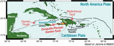
The Haiti earthquake occurred on the Enriquillo-Plantain Garden Fault. The quake struck along about one-tenth of the 500-km-long roughly east-west fault that extends across the island of Hispaniola. The fault is similar to the San Andreas, in that two plates are slipping sideways past each other -the Caribbean plate to the south is sliding (jumping, actually, since the plates 'stick' and then break with a jerk) easterly relative to the Gonvave Platelet (a piece sheared off the North American Plate). In 1946 a much larger quake (8.6) struck in the northeast of Hispaniola, so this is an area of active seismicity.

The arc of the islands of the Lesser Antilles, to the east of Hispaniola, is a volcanic arc marking the eastern boundary of the Carib. plate. A major earthquake in that area would more likely trigger major tsunamis since the faults there are compressional and not lateral (similar to the compressional faults underlying coastal Oregon and Washington, compared with the side-by-side lateral San Andreas fault down in California).

The region has many complex faults. When Chris Columbus was asked to describe Hispaniola, legend says he crumpled a piece of paper and said, "There." Many a geologist, trying to map the region, must have been similarly temped to crumple a piece of paper.

For all of us who live in earthquake areas - know that the first waves (p waves) are 'push-pull' waves and relatively smaller than the next set of slower waves (s waves) that are usually much larger and more 'up-down' high amplitude waves. The time between the waves can be seconds or even minutes, depending on how far away you are from the epicenter. Port-au-Prince was only 10 miles away from the shallow focus of the quake, so there was little distinction between p and s waves - but, a 'quake you might experience could give you a few seconds 'warning' to get outside quickly (or under a strong table) before the big ones come.

There will be many aftershocks from this quake, into days and months ahead.

If you have more questions, put up another post.
 
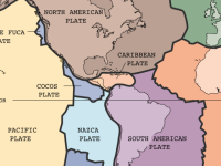
Here are some illustrations to help clarify the geology of the Carib. and Haiti. This first one (from Wikipedia) shows the general location of plates in our hemisphere:

Tectonic_plates_Caribbean.sized.png

This is a map of the Greater Antilles (Cuba, Hispaniola, etc) region showing more geologic detail:

HaitiQuakeMap_100747.jpg

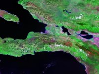
This LandSat photo shows the Port-au-Prince area. The city is the purple region along the coast in the center of the map. Notice the 'straight line' just to the south of the city, bounding the north side of a mountain range - that's the aerial view of the fault zone that slipped and destroyed the city.

enriquillo_plantain_garden_fault_lg.sized.jpg
 
Back
Top