JamesTXSD
Active member
- Joined
- Mar 1, 2005
- Messages
- 7,500
- Reaction score
- 8
- C Dory Year
- 2007
- C Dory Model
- 25 Cruiser
- Hull Identification Number
- TBA
- Vessel Name
- "Wild Blue" (sold 9/14)
JamesTXSD":247sbpg2 said:
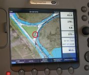
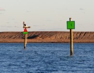
The image above shows that you are coming to an intersection of marked channels; in the image, you are currently heading out (green on the right). The next marker (red and green triangle) shows that the upcoming channel would be heading in from open water to the right (red triangle on the right of that channel). The red/green triangle also tells that the upcoming channel is the "main" channel (priority given to shape and color of that channel). Here's another photo that show the situation (daymarks are circled in red)...

The image that shows the two daymarks was taken while the boat was to the right of the red circle, heading towards the lower left. In this particular situation, it is the intersection of the Brownsville Ship Channel (main) and the Port Isabel Channel (secondary).
If you will be traveling the ICW, you will see markers like this frequently where the Intracoastal crosses inlets and ship channels. Depending on your direction of travel, the colors and shapes may "swap" for a time. We ran into this circumstance in the GICW while heading from Apalachicola to Panama City, where it was several miles of "swap" (the ICW sharing the same water with a channel coming in from the Gulf).
And for David on the bell and length of vessel question: yep, I was not aware of that change (wasn't even absolutely sure it was 12m previously, that's why the "rusty gears"). I guess that also answers Robbi's question about the necessity to update the Chapman's once in a while. We carry a bell on Wild Blue... anyone here ever ring their bell every 60 seconds while at anchor in the fog? Gonna be hard to get sleep. :roll:
Interesting stuff here... hope y'all are enjoying the thread.
Best wishes,
Jim

