C-Dory 22 Accident

My thought is as someone else earlier mentioned, the photo may very well be a stock photo the media uses. It wouldn't be the first time...
 
hardee":7cxeeh3w said:
Gary and Colleen, your video going in across the bar shows the tip of the North Jetty I think.
The one “Crossing the Yaquina River Bar, 6/29/20” I believe shows the area where that Area D breaker line is, (Just right at the end) and it is in the 1 mile range where some of the breakers are busting on the shallows. That could do serious mayhem.


Harvey
SleepyC:moon

9_Sept_Seq_2019_Cal.thumb.jpg

Hi Harvey. You are correct. Our video shows the tip of the north jetty upon entering the Yaquina. We have seen many vessels take a short cut and start their entry for the Yaquina by crossing through the north reefs enroute for the Yaquina between this north jetty and buoy #3. The Captains making this choice do so out of convenience. It is a bad habit, poor choice and is foolish. It is really unknown as to what really took place for things to go wrong which led to this fatality. My hope for all mariners in doing this crossing is that they follow the specific Coast Guard recommendations miles out before they make their approach. Gary.
 
colbysmith":15gdn755 said:
My thought is as someone else earlier mentioned, the photo may very well be a stock photo the media uses. It wouldn't be the first time...

Wouldn't be the first time the make of vehicle reported in an accident was wrong either.
 
ssobol":bwjbeb37 said:
colbysmith":bwjbeb37 said:
My thought is as someone else earlier mentioned, the photo may very well be a stock photo the media uses. It wouldn't be the first time...

Wouldn't be the first time the make of vehicle reported in an accident was wrong either.

Just looking back over this. The hull shape does look like a C-Dory (look at where the bottom color is in relation to where the strake line on the bow is), and the hull does flatten going aft.

Also, USCG does photo every rescue. I would guess, and true, that is all that it is, but that was a tweet, and that info on the rescue most likely came initially from the USCG with the photo. I don't think the CG is in the habit of sending out info with "stock" images.

As to the "no outboard" showing, Could it have tipped to the UP position with the boat upside down, either in that position or in the process of getting to upside down?

I placed a call to the reporter from the Statesman. Will see if I get any response there, and if I do I will post it here.

Harvey
SleepyC :moon

HH_Cal_09_06_Jun.thumb.jpg
 
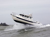
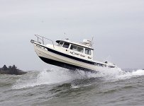
We have been in some relatively big waves, most notably when going from Portage, Indiana, to Chicago on Lake Michigan. By our standards, it was a "no go" day but we went anyway. We were uncomfortable but never felt unsafe. The moral for me I guess is stay away reefs and bars in the ocean at the mouth of a river. Remember this photo of the C-Dory at the Columbia River bar?

4cc8836862acfa4318aae7664f8d3f27.jpg
 
A single remarkable photo could be simple luck.

Multiple photos, like side referenced above, are more
of a reflection on the expertise of the helmsman.

An incompetent helmsman, in big seas or bad weather,
can get the most seaworthy boat into big trouble.

Aye.
 
Pat Anderson":1f0sg1a2 said:
We have been in some relatively big waves, most notably when going from Portage, Indiana, to Chicago on Lake Michigan. By our standards, it was a "no go" day but we went anyway. We were uncomfortable but never felt unsafe. The moral for me I guess is stay away reefs and bars in the ocean at the mouth of a river. Remember this photo of the C-Dory at the Columbia River bar?

4cc8836862acfa4318aae7664f8d3f27.jpg

Rich set me a series of photos when they did that. He told me that they had pictures with the boat all the way out of the water with the props showing. He said they weren't publish any of those for fear someone else would try it.
 
If I remember correctly, the pictures of the pictures being taken were even more impressive. I believe the photographer was hanging just above the wave tops suspended from a helicopter while shooting some of them. :disgust
 
In 2001 on the return from exploring remote rivers & lakes in Alaska & the Yukon & Northwest Territories in our 12.5 foot inflatable, we stopped at Newport, Oregon & went out & back the Yaquina River ocean entrance. The swell was about 8 feet then & very evident to us without charts, the reef line to the north & south off the end of the jetty sides & the proper way to enter & exit the entrance, which was well marked. Unless there was steerage or motor failure, the boat shouldn’t have been in the reef area in a 10 foot swell.

Big swells not overly steep only become dangerous to a 22 foot C-Dory when the wind, tide or shallow water causes them to turn into breakers. Just before our first cruise to the Gulf of Alaska side of the Chichagof Island wilderness a fishing boat captain who had fished those waters for the previous 40 years advised us to not go out in over 10 foot swells, no matter how far spaced or low the wind. He said, the danger was from the many shallow spots “reefs” in the area going out several miles from shore. We had to go through this area to enter Mirror Harbor. We did go out the first time in 10 foot swells following a gale where the waves had been 20 foot plus. With careful boat placement avoiding the reefs, we have now transited this & many other areas like it many times. No boat does well over submerged reefs during larger swells & they are to be avoided unless no other choice.

The photos of the C-Dory on the Columbia Bar are very dramatic, but have little to do with the actual rough sea ability of the CD22. If those waves that day were breaking that boat wouldn’t survive there. The CD22 performs extremely well compared to most other 22 foot boats in very confused seas up to about 7 feet, tracking down the front of a large swell & many other conditions, other then going into 4 foot or higher steep short spaced waves.

Jay
 
A rule of thumb is that one should go the "Sea Buoy" before turning to go in a channel. In this case the Sea Buoy is 1.3 miles from the actual entrance between the jetties.

The article says the boat capsized off Nye Beach about 2.5 miles North of the entrance to the bay--where there is an extension of Yaquina Reef.

We were headed out of there at about 5 AM, still dark and a bit of fog in our Cal 46. The CG had said there were going to do a patrol early in the AM, and would let us know the state of the entrance. As we came to the dog Leg the CG boat was coming back--and shined their spotlight on us. Of course we lost all visual reference (long before GPS chart plotters). Fortunately I had written down the compass headings for each part of the legs going out--and was able to rely on this until our vision returned. The radar gave an all around echo, because of the cliffs and jetties so was of little help...Moral--know compass courses into these difficult harbor entrances also. Use all aids available.
 
I tried to look it up a week or so ago, but didn't come up with anything more than the update from December 21st. I'm interested in the accident too if anyone has any more information...
 
Back
Top