2007 Alaska northern inland passage wilderness cruise

Great Video. In Ford's Terror, it looked like you had more ice than we did when we went in there in 1993 and 1994. Also it is a different prospective: we had a 7 knot boat which drew 6 feet, so we could only go in and out at high slack water.

Thanks for taking and sharing the videos.
 
Added another video of map showing cruise routes from Elfin Cove to end of cruise. Put in two links to this video one on the travelogue on Part 4 date 6-6-07. The other on page 4 with the other 10 video links grouped together.

El and Bill, Andy and Bob, thanks for the comments. And Bob, we too noticed much more ice this year in Fords Terror and Holkham Bay. Also there was ice and snow in the chutes coming off the cliffs further into Fords Terror Inlet.

These videos even in poor quality take a lot of time to download onto computer, edit, upload to host and then add to travelogue. If they really don't add to the travelogue would just as soon not do in the future. Would like to know if its worth it to those who have viewed or not. Its not going to hurt my feeling if they don't, but I don't like doing the work if it really doesn't add to the travelogue.

Jay
 
Hi Jay,

I have watched every one of the videos and have enjoyed them. I have not read all of the posts but have skimmed them. I really found the bear and kayakers, the rough water, the ice, and driving the Mokia the most interesting.

I know it takes a lot of time so you have to decide but I do enjoy them.

Steve
 
:D Jay, I'm not very knowledgable when it comes to video or computers, so I can't put a value on the effort made to put them on this C-Brat site.
Only you can do that.

But I can say that I've read every thread and saw every video and am extremely happy that you took the effort to share your trip.
:thup Thank you.

Allan
 
Jay & Jolee - I had been absent from this site for a few weeks, so it has taken me some time to catch up. Actually, I am not caught up, but your adventures and now videos are some of the post I always read.

I had read your latest travel-log as you posted it. After I saw you added video to it, I re-read it and viewed the videos in their proper place so it made more sense to me. I started around 10 pm last night and finished just after 1 am this morning.

This may be a little selfish on my part, but I hope you continue to post about your adventures and also add the video where appropriate.

I really enjoy reading and viewing/listening to your's and Jolee's adventures.

________
Dave dlt.gif
 
I just wandered through this whole thread, enjoyed the videos great stuff. I had a nice flashback....or maybe it was post traumatic stress. Pelican and Elfin Cove are sure special places, I can't wait to return. I finish school June 13 & the boss has me a flight booked for the 14th...aint soon enough :)

Good stuff Jay & Jolee, do you have any more pics, videos or stories on your trip up Dundas Bay? That looks like some rugged, interesting country, maybe to rugged for critters?
 
Steve and Allen—Your comments were greatly appreciated. Those and the comments by El & Bill and Bob with your expressed enjoyment made me pleased that I had made the effort to make them available for viewing.

Dave, can’t believe you took the time to go completely through this thread with what I know your having to deal with now. Hope it took your mind off the flood and wreck for a while. Your comments followed by Ken’s left me feeling great. And Ken just to hold you over to June 14, I added a video of us going from Elfin Cove to Dundas Bay. If you get the time away from the work part of your summer it’s an area fairly close to Elfin Cove that may be worth your while to check out. Especially where the Dundas River enters the Inlet.
video Elfin Cove to Dundas Bay

Jay
 
Excellent video Jay! I've seen most of your others, all very well done and narrated. Next I need to whip out my maps of the area to follow along your points of interest. Someday, I plan a similar cruise.

One question, while in Dundas Bay you said there's really no place to find shelter in a blow. Seems like you were surrounded by mountains on at least 3 sides. Is the problem you never know which way the wind is going to come from? Water too deep to anchor? Curious.

Thanks.
 
Jay and Jolee,

This is Anne........(Ron from Meander's other half. I have never posted anything before and actually rarely look at this site).

Ron just showed me all the video's that you posted...... OH MY GAWD! THAT'S JUST THE COOLEST! Pick me pick me!!! - if we could go tomorrow I'd be in like a dirty shirt! WOW!! That is my kind of trip! Grizzly Bear's are something else.......deep, spiritual and incredible somehow...... (Obviously calculating at times too! from that one situation - holy smoley!)

The wilderness and the wild life and next to no people - WOW! Thanks so much for sharing your experiences. What a trip and a half..........oh to be retired tomorrow heh!!! Do we have enough $$$ yet - can we, can we, please! ? !

A video camera has never appealed to me before. The zoom on your regular camera is great too (our next trip totally needs better camera equipment, I know now) - you have inspired me in more ways than one!

We went grizzly bear hunting for a couple of days in our 3 week trip from Prince Rupert to Vancouver this Aug./Sept. on the Inside Passage of the British Columbia coast - Kynoch & Mussel Inlet - (first time hunting grizzlies). We only have a Soar Inflatable kayak (no motor) - kind of similarly.......but no gun! - only flares as ammo!! And not the quick escape ability that you had. We wouldn't do it that way again, but it was such an incredible adrenalin rush and awesome. I was so 'with you in your videos - IT WAS SOOO ENJOYABLE!!' (We actually didn't see any grizzlies on our short adventure even tho we were told and knew they were around! - maybe that was a blessing!) I can't wait to go back and loved being reminded of how very very incredibly cool & deeply spiritual (kind of like orcas somehow) that is!

You did an awesome job of filming and sound/telling and driving and everything at the same time and now sharing it in a well told/written way as well.
THANKS A TON!
Anne
 
Hi Jay and Jolee,

I'm a Mac guy using Safari as the browser... unable to see your videos. I just downloaded Firefox so I'd be able to see 'em. Just started and what I see looks great. Thanks for taking the time to share this with us.

Best wishes,
Jim B.
 
Hi Jay,

You mentioned in a post that your regular fare was peanut butter and granola. I would be interested in hearing how you provisioned for your trip. I am sure you had more than peanut butter and granola, but did you simplify the food supplies to keep things easy? If so how did that work out?

With all the extra fuel you took there must have been other things that you decided to do without because of space and weight.

Another plus of the videos is being able to share them with others that will never read the posts.

Thanks,
Steve
 
Steve (Dora-Jean) –Thanks for the comments. Two of the videos I posted were of me explaining the routes and different places of interest on a Northern Inland Passage Map. Those along with your own maps and the travelogue should give you a good edge if you decide to cruise this area. These are the direct links to the map videos.

video Map of Cruise Routes
video 2nd Map of Cruise Routes from Elfin Cove to End of Cruise

In answer to your question on Dundas Bay and lack of shelter in case of a blow, I was referring only to the Dundas River outlet. It’s a fantastic spot with as much or more land, air and sea wildlife as we had seen anywhere on the cruise. We would have loved to anchor and then explore up this river in the mokai. It’s a place we plan on returning to and trying again in the future. There are several very good anchorages at the head of Dundas Bay, but the only wildlife we saw there was some black bears, so with itchy feet we left there without spending the night. When we have more time, it’s another place we plan on returning to and spending several days.

Anne—All I can say is WOW!!! Too. Those Hollywood types would sure be envious of a review like that. Really am pleased you really enjoyed the combination of video, photo and writing of the cruise. Love your enthusiasm and it sounds like you and Ron had some fun times out bear hunting and exploring also. I plan on retiring in 2 years and then Jo-Lee and I plan on spending a lot more future time doing our style of bear hunting, exploring, fishing etc in the described area. Would be great if we could meet up there sometime? For us it doesn’t get any better than the Elfin Cove and Pelican area of the Northern Inland Passage and I think I can guarantee you seeing all the grizzlies you want.

We bought the Hunkydory then the Puffin from Gordon Lamont and family in Jan 2003 there in Vancouver, BC. They had the boat moored in a Marina near or at Port Moody and we went for a trail run out Howe Sound. That was our first ride in a C-Dory boat.

Jim—With past videos I posted to the C-Dory site I used YouTube and Mydea as host, so they were available to Mac users too. YouTube is free and would work with the Mac and the Other, but Mydea, though expensive has much superior video quality, so went with Mydea only.. Wished it would work with the Mac too. This time with 30 separate videos to upload to host and then post it was just too much to do both. Pleased you let me know you downloaded firefox to view the videos.

Steve (Seabran) – Actually we did eat a lot of peanut butter and honey-jelly sandwiches and our own mix of granola, but your right it wasn’t the only fare. We do try to keep it simple and neither of us requires anything special in food. Start out from home with all the basics. Coffee, salt, sugar, hot cereal mix and canned food in the form of chowder, lentils, stew and many jars of our favorite applesauce. In the ice chest goes butter, half & half for cereal and coffee, sandwich type meats, cheese and pop. Buy in harbors along the way only fresh fruit and veggies, bread, half & half, cheese and sandwich meat like mainly ham. On this trip only ate out twice and that was once in Petersburg and Pelican other than when invited to eat with another boater in their boat. It works fine for us and the way we have been doing it for many years whether on the water or an extended road water trip.

Even with the extra fuel we do without very little. Many back ups and safety stuff and we run extremely heavy. Use same prop combination on ocean as we would run on Yellowstone Lake at almost 8000 ft running light. If I remember right max speed is only about 20 mph at 5300 rpm. For us to plan for such a cruise takes in all our available time starting in the fall to when we leave in the spring or early summer and that includes many hours on my job where I’m fortunate to have time available to use for planning. I know many feel we take to many chances and maybe we do due to the inherent risks of such a cruise, but a successful trip such as this can’t be made without major pre-planning. The amazing thing is space and weight and the distribution of the weight really wasn’t a problem. We did have to do shifting of items back and forth from the cabin to the sleeping area. After our 2003 trip it kinda became instinctive to shift items around, so we always were well balanced. We really don’t think about it, but it is a consideration that must be made. The boat never felt unsafe in its handling due to weight distribution even with the towing of the mokai in some very rough water. In several instances we found ourselves in sea conditions that we had never experienced before, but the boat always did what I wanted it to when needed.

Jay
 
Jay - I noticed in your videos, you or Jolee are often manually wiping your windshield. Have you given any thought to replacing the wipers with electric ones?

I am not impressed with the electric wipers on my boat but they sure beat manual ones. I find the speed is too fast and most of the time I just need an occasional wipe, so this winter I plan on adding a delay/intermittent control to my wipers.

________
Dave dlt.gif
 
Dave--Hope to do just that before our next trip north.

There were times when trying to steer, video ect and keeping the spray, rain or fog off the windows especially in some of those conditions and places made for some juggling. Would have been much easier and perhaps safer with electric wipers.

Its doing this kinda stuff that leaves us a little jaded toward some of the safety concerns we see expressed on this site, like "always" wearing a pfd when in a boat and never boating in the dark.

Jay
 
Dora~Jean":1ay2p9oq said:
Excellent video Jay! I've seen most of your others, all very well done and narrated. Next I need to whip out my maps of the area to follow along your points of interest. Someday, I plan a similar cruise.

One question, while in Dundas Bay you said there's really no place to find shelter in a blow. Seems like you were surrounded by mountains on at least 3 sides. Is the problem you never know which way the wind is going to come from? Water too deep to anchor? Curious.

Thanks.

Steve

Didn't answer this question very well the first time, so am going to try again. We are extremely picky in our choice of anchorages especially when cruising alone in these isolated areas. We have been woke up in the middle of the night with the boat being tossed about and its now one of the foremost things we try to avoid. The Dundas River outlet to bay does drop off rapidly to deep and is bordered by a very shallow or bare tidal area with the river leaving changing channels, but I think we could have found a spot to hold. The problem was more the complete opening to south with no nitch to get behind and the prevalent south winds with no easy or just plain no retreat if needed.

We differently want to go back and explore the Dundas River with the Mokai, so have worked out a future plan. North Inian Pass and the outer Dundas Bay area all have extreme currents, so matching caution must be used. During a period of stable or either north or north west winds anchoring should be ok or possibly spending night in Inian Cove six miles to the south across North Inian Pass and picking the right tide times for crossing back and forth.

Like our weather forecast here at home the forecast in that area was not always correct, so when we could get a report we still had a tendency to be Leary of totally depending on it.

Jay
 
Thanks Jay, now I understand, currents, dropoffs, exposure to the prevailing winds, makes sense. It sounds similar to finding a good anchorage in the Bahamas, either you're in too much current, too much exposure or too close to shore to swing 360 deg if needed. Your plan sounds good, pick a more protected anchorage at night, then maybe 'lunch anchor' where you want to explore for a few hours at a time. I appreciate your analysis, thanks.
 
Ken

Thanks for the current & tide update web address. As that example of today shows the currents in that area with wind and swells off the Pacific can't be taken lightly. We have Nobletec and when its working it gives us all of that and more. This year it wasn't working, so it was back to the hand book and estimating. That address could come in handy in such a future case and could also be well used for anyone else planning on cruising this area.

Do you frequently cross these passes on charters and if you do with those larger boats is it necessery the majority of the time to cross them during slack or flood.

All

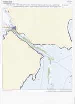
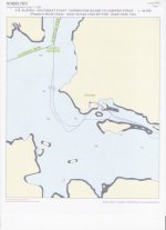
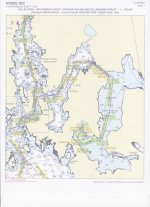
These following copies of charts with routes and tracks of the Anna and Sister Lake area of Chichagof-Yacobi Wilderness gives a good example of why a person when accessing these kind of areas can't depend on charts or GPS and should have previous experience with shallow water running in heavy currents before attempting such a cruise.

These chart copies only show a small portion of our tracks due to nobletec not starting back up at different times and in the process losing much of our track record.

This is chart copy of the boat track and route accessing Sister Lake from Anna Lake, Chichagof Wilderness.

scan.jpg

This is chart copy of anchorage during gale on Sister Lake

scan0001.jpg

This is a chart copy of tracks and routes from Elbow Passage to Sister Lake.

scan0002.jpg

These show if you just follow the gps and charts without thoroughly observing where you really are the planned destination is not going to be made.

Jay
 
It looks like you did a little off roading there. You sure do a fine job of documenting your adventures.

We run through South Inian at will. The Coast Pilot and others say to give Point Lavinia a wide berth as there is a big uncharted rock that is only visable at low tide over there. Following the north side of the pass puts you square into a very nasty set of standing waves that appear at the west entrance of the pass on the ebb. Coming and going from Elfin Cove, we cut between the rock and Point L. and miss all the nastyness. Once past that bottle neck at the west entrance, the pass isn't to bad. It's a pretty narrow slot between the rock and the Point and wouldn't recomend anybody using that route that isn't intimate with it.
 
Jay and Jolee,

Thanks for sharing your trip with us. We love the photos and videos. And the Mokai 8) Wow. I received the DVD from Mokai last week and have shared it and your videos with at least a dozen people. Have you thought of adding a second Mokai? We may have to add at least one for our next trip.

We didn’t make it out to see Ken in Pelican or Elfin Cove this trip due to time limitations and small craft warnings on Icy Strait. We are planning for our next trip in 2009 and tentatively are thinking of towing to Skagway. Your trip on the outside is a real inspiration. Of course Elfin and Pelican are part of that trip :wink

Thanks,

Don and Dee
 
Back
Top