Tropical Storm Arthur

El and Bill

New member
Heads Up!

Off northeast Florida now and is predicted to move northerly up the east coast all week long. Be prudent and stay tucked inside if you are thinking of any boating along that area in the next 5 days or so.

Bill F
 
As Arthur moves up the coast would like to hear from C-Brats who are experiencing the effects of the storm- I am working the next three days on the ferry that goes across the Delaware Bay from Cape May, Nj to Lewes Delaware- also live on a barrier island so I will report the effects of this storm as it impacts NJ and the Delaware Bay. Hope everyone on the East Coast has made their preparations by now and have their boats in a safe hurricane hole.
 
Thanks, Bill. We watch these things pretty carefully in our part of the world…right now it looks like the Cape Hatteras area is in the most danger, and 10 to 20% chance of hurricane force winds late Thursday night,early Friday Morning. It looks like it will be picking up foreword speed and by Saturday evening be off Nova Scotia.

Amoung the Apps we like are Hurricane HD, which shows dynamic maps as well as the forecast track, a large number of models, discussions, advisories, wind advisories etc all in one place. There are several others which go into the metorology for those so inclined: such as Weather Geek Pro or even Weather Track (shows all GRIB files), or Radar Scope ($10) which shows real time Level 3 Radar from each of the major stations.

I also enjoy Dr. Jeff Mc Master's on Wunderground.com, whose latest blog predicts it will be a Hurricane early tomorrow, with brush the N. Carolina Cost in Friday AM.

Dr Peter Ray of FSU has an e-mail subscription service (free) which is excellent--one of the best--for Gulf Coast.

Our thoughts are with those who may be in the track or Arthur.
 
Riding it out at Pamlico Beach. Doesn't look like its gonna be a lot of fun here - now saying CAT2. 5ft storm surge.
JUST took my trailer in to the shop :( - Seaweed will have to ride it out on the boat lift! We have 35miles of open water to the SE :( :| :(
I've battened down everything and done all I can do. Knuckles hurting from crossing fingers.......
 
So far, the storm has not been noteworthy at my location (not that I would want it to be). My wind gauge is showing top wind (gust) at 23 kts and lower wind at about 12 kts. I am protected by being in a creek, so wind information is not always correct, due to the close proximity of buildings and trees.

Storm surge does not seem to be a factor, as we are at 4 hours after high tide and the water level below my dock appears close to normal for that tide range.
 
Not bad here. We did OK. Cleanup begins.

From yesterday afternoon.


20140703_195508.jpg
 
Cape May Lewes Ferry running in Del. Bay today- snotty out here but no worse then a NorEastener-2-3 feet-(so the Marine forecaster say- seems higher to me).Ocean off Sea Isle 6-9 feet. Heavy rain this morning but that has also diminished-winds 20 or so with gusts up to 30.

Guess Nantucket now in the cross-hairs.
 
thataway":12b76jgd said:
Ray,
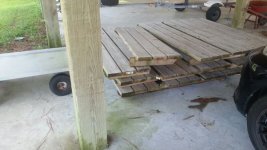
Did you pull every other plank from the deck?

That's exactly what I was wondering when I looked at the photo. The gaps looked just a little wider than you'd expect even in a dock with gaps, and it would allow for a bit less resistance to water on a fixed dock.

Or are we seeing things?
 
Yes, we made some frames out of every set of three boards our so (based on pilings). The aft end locks under the fixed board sets with a "tail" of 2x4 and two ceramic coated screws for the other end. It's an experiment for us. This was the first year trying it out. It was very easy to break down. We didn't lose any additional boards with the pressure relieved.

IMG_2014070435741.jpg
 
Back
Top