Brats,
The problem with electronic charting is one of perceived accuracy. The screen shows the chart and the boat symbol and we think we are there where the plotter shows us to be.
We might have all heard the acronym GIGO(garbage in--garbage out). The position shown is only as good as the chart data.
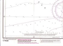
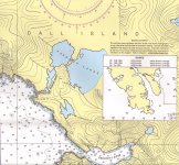
Consider this: I purchased a chart of Dall Is Alaska this summer. Here is a scan of the chart number and edition date.

This shows the edition date and the last corrections. Looks good, right?
However, here is scan of another part of the same chart. This box labeled source shows the dates that the surveys were made.

So this chart, which was corrected up to date when purchased, is based on survey data from BEFORE 1900 TO 1969 and the soundings are only partial.
For those of you using a chartplotter, do you know how recent your chart data is? In the part of Alaska shown on this chart, the chart data is actually old, and incomplete. Isolated rocks can and do exist.
Do not assume that just because your plotter shows a nice new image that that image is accurate. This is a problem with all electronic images. A typewritten page from 1940 looks, feels, and smells old. We know that that data is OLD. If that same data is typed into a computer and displayed, it looks as new as yesterdays data. Do not be fooled by the nice crisp clear image on your plotter.
Navigation occurs in the MIND of the navigator, make sure YOUR mind is out there ahead of your boat, and not playing a video game on your screen.


