Steve-in-SEA
New member
I thought I'd share my experience getting a Garmin chart plotter (ECHOMAP Plus 64cv) and Standard Horizon VHF (Standard Horizon GX2400) to talk to each other via NMEA, in the hopes it might save someone else some time.
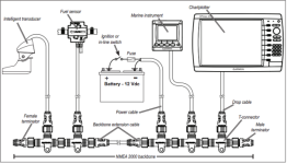
I started by networking the two devices with a NMEA 2000 backbone kit from Ancor Marine, but neither device would see each other.
I called Standard Horizon support, who did the best they could given the situation... from their perspective, it could have been their radio... or the chart plotter, the backbone, lack of power to the backbone... or some other form of user user. In the end, things still weren't working.
I next called Garmin Marine support. Over the course of an hour-long call, the support person suggested a NMEA 0138 workaround (VHF blue -> chart plotter brown, high-speed), and suggested that I try a Garmin NMEA 2000 backbone kit to see if that would make a difference.
So I ordered the Garmin NMEA 2000 backbone, and it did work. Both devices see each other. I'm seeing AIS targets on the chart plotter, for instance.
One would think that one "standard" N2K network backbone would work just as well as the next, but unfortunately, that doesn't appear to be the case.
Unfortunately, I ran out of time with the boat and so was unable to swap out components (tee connectors, power injector, terminators) to narrow down the failure, which would have been an interesting experiment.
If anyone has ideas about what may have been the trouble here, would be interested in hearing/learning now. I'm new at this.
Thanks!
PS: props to Garmin marine technical support!
References:
- Ancor Marine kit: https://www.amazon.com/gp/product/B074KHXXMF
- NMEA 2000® Starter Kit, 010-11442-00 https://www.amazon.com/Garmin-010-11442-00-Nmea-2000-Starter/dp/B0030EMZYW


