IPad 64G, WiFi, 3G, 1st Gen, $499, Target

BrentB

New member
http://www.target.com/p/Apple-64GB-firs ... NM=Primary

$499.99 plus $5 shipping
Reg:$729.99- Save $230.00 (32%)

Apple® 64GB first-generation iPad® with Wi-Fi +3G (MC497LL/A)
The first-generation iPad®. It’s the best way to experience the web, email, photos, and videos. All on a big beautiful Multi-Touch screen. With just the touch of a finger.


•Maximum Resolution: 1024 x 768
•Display Features: LED Display, Touch Screen
•Processor Brand: Apple
•Processor Speed: Up to 1.0 Ghz
•Processor Type: Apple A4
•Data Storage Capacity: 64GB Hard Drive Capacity
•Wireless Technology: Bluetooth 2.1 + EDR
•Wireless Standard: IEEE 802.11a/b/g/n
•Input Type: Dock Connector Port
•Output Type: Headphone Jack
•Audio Features: Built-In Speakers
•Battery Charge Life: Up to 9 Hours
•Includes: Dock Connector to USB Cable
 
That's tempting! The 32GB model is $449 too. A guy at my work who bought a Ranger Tug before I got my C-Dory recommended getting an iPad 3G instead of upgrading my tiny GPS. He said there's a really good marine nav program for $20 or so. I don't know how useful it is compared to a $700 Garmin, but the screen is certainly nicer, and I already have a minimal Furuno GPS, so...
 
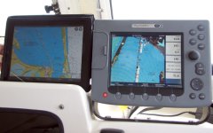
The GPS nav function with Navionics is outstanding on the iPad. Good screen size and the entire US and Canada available on one $40 app. I have spent many times over the cost of the iPad on just chart chips alone for the E-80 on our boat.

There are a few limitations, the main one being the chart is north-up instead of course-up. With two chartplotters onboard previously, I kept one each way, so that hasn't been an issue for me. I have all the US charts on DVDs, and can use those on my MacBook Pro. I see no need for buying expensive paper charts in the future, since we have the Raymarine, the iPad, and the equivalence of all paper charts on the DVD... and each of those devices is on a separate power source. I will still buy cruising guides for any new areas we visit, just won't be backing up the chart chips with paper.

I know I've said this before, but it bears repeating: NOT every iPad is capable of marine navigation without being connected to the internet. The wifi only model iPads DO NOT have a built-in GPS chip. ONLY THE 3G model iPads have the built-in GPS chip, so if you intend to use it for navigation, be sure to buy one of the 3G models.

iPadChartplotterE.jpg

The iPad next to the E-80.
 
I have an I-Pad II 3G, 64K and the Navionics app. The marine GPS is most impressive especially compared to my Garmin handheld GPS. The mapping including the depth contours for the Canadian Pacific coast are excellent. I would highly recommend the I-Pad 3G and the Navionics app especially for the excellent price of $500. Mine cost me almost $900.
Cheers!
wapiti
 
I'm wondering why the Navionics app is North-up only...I prefer course-up which is why I dislike raster charts on a PC...

Using OpenCPN with raster charts in course-up means that everything is sideways or upside down except when traveling North...very annoying.

I would think Navionics could do better.
 
Anna Leigh":3o5uesgo said:
If it had GPS I would jump on it.

Just need to buy a GPS app
I bought Navionics East and West apps when first released for $6 each.

I am looking an auto GPS app now to replace older TOMTOM which is still functional but they charge alot for map ugrades
 
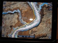
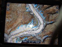
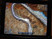
I have the 3G IPAD & though excellent for planning and situational awareness of the big picture, I would not trust it at all for exact placement of boat in water. At Lake Powell the Ipad with Navionics wandered about from water to land along the general course we would take.
 
Hunkydory":3ommmap9 said:
I would not trust it at all for exact placement of boat in water.

Can't be worse than my Furuno GPS which is only capable of drawing a track of the boat's position. No land, no depth, nothing.
 
ferret30":uzo14wey said:
Hunkydory":uzo14wey said:
I would not trust it at all for exact placement of boat in water.

Can't be worse than my Furuno GPS which is only capable of drawing a track of the boat's position. No land, no depth, nothing.

Maybe it will do better in other areas than Lake Powell or even it could be defective, but for now & there it only gave general heading & placement on what I would call good charts. Thing is no matter how accurate the charts if the GPS doesn't put you where you acturally are on the chart to me its not good for navigation by its self in the places I have been or am planning to go in the future. I was using it in conjuction with three other gps's that all agreed on very specific locations as we cruised.
 
I have the first version of the i pad, and have used the second version--for our navigation work the first version (3 G--which has the GPS chip) is excellent).

I find that my I pad is accurate enough it will tell me which room I am in the house consistently.

I suspect that either the cartography for Lake Powell is off (of course with the varying water levels, this is a very likely possibility)--or you have a defective unit.

We have used the i pad both on the water and in the RV, and found it be extremely accurate with its GPS...

We do get spoiled with our chart plotters--just remember that all paper charts are "North up"....you can turn them any way you want--that is not an option with the i pad however....but you can tune your mind to the North up chart plotting.
 
Bob I too have found it extremely accurate on land. In the main channel of Lake Powell it was continually off while the other gps's were spot on. Possibly has something to do with the canyon walls, but the Garmins only lost accruacy when in very narrow off shoot canyons. Others at the Lake Powell gathering told me their experience with the Ipad there was the same as mine. Planning on using it in Southeast Alaska this coming summer so will see how it does there.
 
Hunkydory":g3ax47tv said:
Bob I too have found it extremely accurate on land. In the main channel of Lake Powell it was continually off while the other gps's were spot on. Possibly has something to do with the canyon walls, but the Garmins only lost accruacy when in very narrow off shoot canyons. Others at the Lake Powell gathering told me their experience with the Ipad there was the same as mine. Planning on using it in Southeast Alaska this coming summer so will see how it does there.

My ipad was spot on with my Lowrance, my Android phone and my visuals when I was in Princess Louisa inlet. That's perhaps not as steep or deep a canyon but I haven't had any deviation yet between my ipad running Navionics and my fixed mount GPS.
 
rogerbum":1sy3vxku said:
Hunkydory":1sy3vxku said:
Bob I too have found it extremely accurate on land. In the main channel of Lake Powell it was continually off while the other gps's were spot on. Possibly has something to do with the canyon walls, but the Garmins only lost accruacy when in very narrow off shoot canyons. Others at the Lake Powell gathering told me their experience with the Ipad there was the same as mine. Planning on using it in Southeast Alaska this coming summer so will see how it does there.

My ipad was spot on with my Lowrance, my Android phone and my visuals when I was in Princess Louisa inlet. That's perhaps not as steep or deep a canyon but I haven't had any deviation yet between my ipad running Navionics and my fixed mount GPS.

And that is indeed good news to me!! Just what I was hoping for when purchasing the ipad, so hope it does the same for me in Southeast Alaska.
 
Any chartplotter (or chartplotting app) is only as good as the cartography. There are times when my big bucks Raymarine with the Platinum chip shows that I am on land... BUT, that is repeatable: if I return to that spot, it always shows that I am on land. The problem isn't with the GPS, it's with the charts that were used to make the e-charts. In areas where there is current cartography, the chartplotting will generally be very accurate... and conversely, in areas that haven't had new mapping in 50 or 100 years, you can expect the charts will be off some. It is every bit as accurate (OK, maybe a LOT more accurate) than working with a chart and a compass, given the same mapping data.

That said, the Navionics app on the iPad matches up well with the Navionics Platinum chip on the Raymarine. Same place at the same time - however accurate the mapping might be.

All of those are considered "aids" to navigation. One still has to use their eyeballs, and look around to maintain positional awareness. When working in close in low visibility conditions, I do not trust JUST the chartplotter - that's when radar and a depth finder become very important navigational tools... just as they would if you were working from paper charts. Oh, and your ears and eyes (Can you hear the waves breaking on the shore?? Can you see that daymark that is supposed to be right in front of you??)

Frankly, I trust my chartplotter AND the iPad. I trust them more than I would the compass and a paper chart. I was a pilot for a lot of years; flew plenty of IFR. Those IFR approach charts are constantly updated... unlike most marine charting. More and more airlines and commercial aviation operators are going with iPads in the cockpit - because they are accurate and repeatable, in large part due to the accurate mapping data.

So, when your GPS shows that you are on land and you can clearly see that you are still in the water, if you could possibly be that accurate with your compass and the paper chart, it, too, would likely show that you are on land. It's as good as we've got, so keep your eyeballs outside the helm (part of that required "keeping a watch") and use all the resources you have.

Trust, but verify. :wink:

Best wishes,
Jim B.
 
BrentB":17ce3ylr said:
http://www.target.com/p/Apple-64GB-first-generation-iPad-with-Wi-Fi-3G-MC497LL-A/-/A-13022392?ref=tgt_adv_xasd0001&AFID=Performics_Skimlinks&LNM=Primary

$499.99 plus $5 shipping
Reg:$729.99- Save $230.00 (32%)

Apple® 64GB first-generation iPad® with Wi-Fi +3G (MC497LL/A)
The first-generation iPad®. It’s the best way to experience the web, email, photos, and videos. All on a big beautiful Multi-Touch screen. With just the touch of a finger.


•Maximum Resolution: 1024 x 768
•Display Features: LED Display, Touch Screen
•Processor Brand: Apple
•Processor Speed: Up to 1.0 Ghz
•Processor Type: Apple A4
•Data Storage Capacity: 64GB Hard Drive Capacity
•Wireless Technology: Bluetooth 2.1 + EDR
•Wireless Standard: IEEE 802.11a/b/g/n
•Input Type: Dock Connector Port
•Output Type: Headphone Jack
•Audio Features: Built-In Speakers
•Battery Charge Life: Up to 9 Hours
•Includes: Dock Connector to USB Cable

any idea which carrier this model is using?
 
I bought my 16GB iPad 3G from Target (back when it was $529). The carrier was AT&T for the iPads they were selling then. But we did not buy the data plan for the iPad, since we have a Verizon MiFi, and of course for GPS navigation with the iPad it does not matter if you are connected to the net except for some of the extras.
 
Back
Top