Garmin Panoptix PS21 Forward Sonar

jkidd

Active member
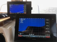
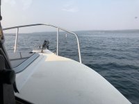
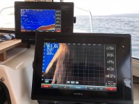
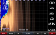
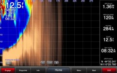
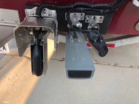
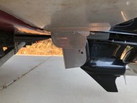
I mounted a Garmin PS21 Sonar on Voyager a couple of weeks ago and just got back from Yellowstone with some results. I spend quite a bit of time at Lake Powell some times by myself 50 miles from the marina in the middle of winter and I feel that the $750 is more than justified for my safety. While it is not perfect the results were what I expected. Below 8 miles an hour it would draw the bottom and show hazards in front of me. At 9 to 10 miles per hour the transducer would stop showing the bottom. I lost 1 to 2 MPH on the top end but didn't feel it pulling to one side I'll know better about the top speed at Lake Powell in Sept. There was no rooster tail. Here are some photos.
IMG_4810.jpg

IMG_4812.sized.jpg

IMG_4833.jpg

IMG_4841.jpg

IMG_4843.jpg

ps21001.sized.jpg

ps21002.sized.jpg
 
Jody,

Your post brings up an issue that I was wondering about when anchoring in Kyuqout. I always turn on my bottom scanner when checking out an anchorage. Lots of places where my stern could be in 15 feet of water and my bow in 3 inches of air. I know that I'm only getting the details from under the stern, where the transducer is located. I've always been concerned that, by the time the stern depth is shallow, the bow might be aground. My question is "how directional is a standard transducer?"

I run mine parallel to the bottom of the boat, mainly to reduce drag, but I think I could bump it "one notch" and have it point (if that's possible) more forward. Probably something like 10 degrees forward. Does that do anything or does the signal simply bounce back and the standard transducer only show the first pulse back and filter the rest?

Mark
 
Jody, thanks for the very instructive and impressive info and photos. I do notice that the photos show the GPS speed at the most detailed and shallow was in the very low range, and the only one at 7 knots was the first photo of the screen. Obviously one would not run as close as you got at 7 knots! But how much difference did you see at 7 and 1 knots?

I suspect that other manufacturers will come up with similar products. It will also be interesting to see how well the system shows the depth thru the "cut offs" where there may be an accumulation of brush on the bottom. We would sneak thru many of these, with outboard up a bit and very slow speed, knowing from experience that they are relatively level on the bottom.

The Garmin info on 2018 transducers is here. This gives the beam width in degrees. Once you get at the margins of the beam width, you will start loosing returns. The beam width will vary with frequency in many of the transducers, as well as model. I doubt that a standard transducer will really give a lot of useful information beyond its limits--and only a few degrees, you will loose bottom lock.
 
Mark I can't say if you tip the regular transducer down a little if it would help in shallow water I don't think it would draw the bottom at the front of the boat. The PS21 transducer beam is 22 degrees side to side and 90 degrees front to back. So the beam covering the surface out in front of the boat and straight down and the stern.

Bob Yes I slowed down to take the photos as not to run into anything while my attention was on the photo. If I was below 9 mph everything was very consistant. When I was in shallow water there were times it would draw the shore when it wasn't there I think that's because the transducer can only see accurately 7 to 8 times the depth your in. So if you were in 10 feet it could see 70 to 80 feet and be accurate. Beyond that it might make some mistakes. The other condition that I saw was going 6 mph and in 170 feet and it lost the bottom however I don't think I would need it in that condition.

While we were out I tried to get Jay to swim out in front of the boat but he was having nothing to do with that. While in the dock I could see vertical line from the bottom to the surface my guess it was a cable holding the docks. It does draw brush on the bottom as a soft target.

On edit I will interested to see what it does in muddy water at the ends of the canyon at Lake Powell.
 
Very, very interesting!

In our clear waters, at slow speeds, I can't imagine needing this, but the technology is impressive!

I like to buy impressive technology, unfortunately. Don't go on impressing me.

Thanks for sharing!
John
 
jkidd":3j3zrq25 said:
Mark I can't say if you tip the regular transducer down a little if it would help in shallow water I don't think it would draw the bottom at the front of the boat. The PS21 transducer beam is 22 degrees side to side and 90 degrees front to back. So the beam covering the surface out in front of the boat and straight down and the stern.

Bob Yes I slowed down to take the photos as not to run into anything while my attention was on the photo. If I was below 9 mph everything was very consistant. When I was in shallow water there were times it would draw the shore when it wasn't there I think that's because the transducer can only see accurately 7 to 8 times the depth your in. So if you were in 10 feet it could see 70 to 80 feet and be accurate. Beyond that it might make some mistakes. The other condition that I saw was going 6 mph and in 170 feet and it lost the bottom however I don't think I would need it in that condition.

While we were out I tried to get Jay to swim out in front of the boat but he was having nothing to do with that. While in the dock I could see vertical line from the bottom to the surface my guess it was a cable holding the docks. It does draw brush on the bottom as a soft target.

On edit I will interested to see what it does in muddy water at the ends of the canyon at Lake Powell.

Yes, I was having nothing to do with swimming in Yellowstone Lake, but can vouch for a very accurate report from Jody. It was quite fun watching him test this & all the other new electronics he has recently installed. It would even be more interesting to see how it all works in various places I’ve explored in SE Alaska.

Jay
 
Jody, That is really neat and great technology. It surprised me at how far below the boat bottom surface it is, but then considering what it is asked to do, makes sense. Seems there is considerable shielding. Is that for mechanical protection or for turbulence suppression?

Harvey
SleepyC :moon

JC_Lately_SleepyC_Flat_Blue_070.thumb.jpg
 
Harvey that would be rooster tail control. I’ll check it again at Lake Powell when I can find some nice flat water and can walk back and get a closer look.
 
Back
Top