Channel markers, buoys

Larry Patrick

New member
Now that were traveling with boat,wondering if there is a good app to learn navigation signs for waterways? The last trip we saw a few that I didn't know,wife tried looking them up as we saw them but didn't find them.
 
Probably the "Safe Skipper" app. It may be from a Brit. so it will have both A & B
for I A L A. One issue is if there are ICW's involved and rivers can also be a challenge.

Also work with the chart and what you see with you binocs or eye.

There are also laminated charts, which are available--and you can keep this aboard. I keep them in my Manual's folder.
 
Thanks for replys,last trip there were 2 signs with red either diagonal or horizontal stripes,thats the one the wife couldn't find on her phone when I asked her to look it up. Never did go between them not knowing what it meant.But it was wide between signs. The intercoastal was near there somewhere. The rough conditions didn't allow a lot of exploring.
 
Larry Patrick":8h7b1t9z said:
last trip there were 2 signs with red either diagonal or horizontal stripes,thats the one the wife couldn't find on her phone when I asked her to look it up. Never did go between them not knowing what it meant.But it was wide between signs. The intercoastal was near there somewhere. The rough conditions didn't allow a lot of exploring.

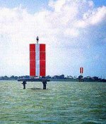
Since you were near (on?) the Intracoastal, I wonder if they could have been range markers? These are often large "signs" that are three vertical stripes (like white-red-white). There will be at least a pair, and how you use them is to line yourself up so you are centered on them (one ahead, one behind) and at that point you know you are in the channel. They can be used for ships entering a basin, or sometimes (on the ICW I have used this type), for transiting a short/narrow passage. Oftentimes they are on girder type foundations, or posts. They can be quite large. I realize you said horizontal, but for some reason range markers came to mind anyway.

Here is a photo of a pair:

rangemarker.jpg
 
I was thinking the same thing. some more info on Range markers.
1. They are always fixed to the land, on some sort of scaffold, piling or up on a bank. I have even seen them way up in the trees. Range Marks will never be on a floating platform, like a buoy.
They can come in various colors, but will always be in some color contrasting to the area behind them so that they are easier to see.
2. The front marker will be lower than the rear one, and as you zero in on the correct course to line them up, it will look like they become one marker with the lines going from the bottom of the front marker up into the far marker, looking contiguous.
3. If you see a pair like in the picture Sunbeam posted, then turn and look 180 degrees behind you and you will probably see another set of range marks. There may be places where there is only one pair of markers, (although I don't think so), and I believe on the chart there will be a set of compass headings, one for the primary and one for the reciprocal.

Hope that helps too.

Harvey
SleepyC :moon

JC_Lately_SleepyC_Flat_Blue_070.thumb.jpg
 
Fairway or channel markers will have either a red and white or green and white configuration. This shows which side the preferred fairway is (to the side of the color, not the white).

Also Junction buoys can have red/green/red, or green/red/green. These are at a junction in the channel, where the preferred route is marked by the top color, but either passage may be acceptable.

Some day markets may have Red rectangle, then inner White Rectangle, and then solid red (same for green/black).

Some cardinal marking buoys have yellow and black strips. There are configurations for North South East and West. For example a "West Mark" would have safe water to the West of the market: From the top of the marker: Yellow, Black yellow stripes.
 
Next time that happens take a picture with you cell phone for a future reference or jump on your VHF and ask the question. Or the next time at a marina happy hour whip out the phone and say what does this marker mean? Cheap and easy. The library should a Chapman Seamanship book available.
D.D.
 
Next time will have her take a photo. They were located where the Carabelle river enters the bay on your way to Dog Island.Thought They were different than those red and white markers in the photo. The stripes were horizontal or diaganol. Had the shallow water alarm go off a few times when trying to get out of the red and green channel markers to make room for bigger fishing boats. Seemed like you had to watch closely ,the buoys took quite a few turns to get from bay to gulf waters. Campground owner said he sees quite a few boats run aground cutting corners. So I watched chart plotter and depth finder closely ,and if I wasn't sure of markers just avoided that area. If it was warm weather would have checked out more of the area didn't want to get on any sand bars ect. Just had wife look at those markers posted she says they look similar ,so maybe that's what they were.
 
It would not be surprising to find a set of Ranges (range markers), in an area where the channel would be narrow, and if you are off the range there could be (very) shallow or rocky shoals.

There is one set not far from here (Mats Mats Bay entrance) where the ranged channel is not much over 30 feet wide at high tide. Going through there one time on an almost zero tide, it was close to 10 feet wide and only about 5 foot depth.

Harvey
SleepyC :moon

1_10_2012_from_Canon_961.highlight.jpg
 
There is a range across the sound in the area you described. I suspect that is what was seen. I haven't been in that area for several years. But range markers don't have to be the colors red and white. There are other colors. The range across the bay there would be about 202 degrees going out, and 22 degrees coming in.

Although this is an official channel, the actual course can shift depending on the migration of sand in the shallow bay. With the C Dory shoal draft, usually you can hug the edge of the channel. Also eye ball navigation works pretty well in this area, by reading the color of the water.

The range is on the NOAA charts (also Garmin and Navionics), as well as being mentioned in several guide books.
 
Thanks for the informed knowledge ,can see the usefulness of waterway guides. Im kind of an extra careful type personality,especially with wife along on the trips. I can see the usefulness of learning all I can about every new location ,each inlet or waterway will be unique. First time in area where Carabella river with decent current dumps into the bay with a lot of markers. It was challenging docking with current the docks weren't parallel instead as you turned into spot ,current wanted to push you against pilings. I rather bump it in and out of gear coming in slow but current wouldn't allow it. It was fun wish we would have had better weather,less wind and better fishing. I hear may and later is the months to fish there. The Appalachacola river 17 miles away was ripping with all the flooding didn't even want to boat there. Looked at it when we visited there.
 
Back
Top