2019 Inside Passage

Some thoughts have recently come to mind. Fuel and Dinghy. I believe my current fuel provisioning is about 100 miles. (Loaded CD22, 40-42 gallons full). I suppose I should "measure" what I'm really getting, as this is just a guestimate... Also, currently I do not have a dinghy, or any other secondary watercraft. Would it be foolish to consider this trip without a dinghy? I am considering the worth of a survival suit. I do have a Personal Locater Beacon, and the usual other safety equipment. (Dual radio's and a handheld. AIS transmitter, etc.) This summer has been busy with other destinations, and I probably won't do a lot of SE Alaska planning until towards the end of the year. Also wondering if anyone else is looking to be cruising in SE Alaska next summer? I'll look into the Sloboat cruise and joining along the route, rather than beginning in the PNW. But I really think I'd prefer to be in the company of other boats for my first time doing this.
 
Colby, I'll throw a clinker in here for you. If you have never done the Gulf Islands, Princess Louisa, Desolation Sound, and the Broughtons, and you have the time, why not launch in Blaine, WA? $7.00 launch and unlimited free parking, you just have to check in with the Harbor Master if you are out more than 5 days, but there is no outside time limit!

You cross from Blaine to Stuart Island to Bedwell Harbour on South Pender Island to clear Canadian customs. Then cruise up inside the Gulf Islands - you can get lots of advice here on the great places to see in the Gulf Islands - to Nanaimo. At Nanaimo, cross the Strait of Georgia (you might need to hang a day or two for suitable weather, I suggest using SailFlow and Marine Weather, so you know wind speed and direction and wave height and period). Princess Louisa Inlet is not to be missed! Then into Desolation Sound, again lots of advice here on what to see in Desolation Sound. Then through Johnstone Strait to the Broughtons - again all the advice you could want here about where to stay in the Broughtons. We ran up the mainland side from Sullivan Bay the Broughtons to round Cape Caution in one day. Once around Cape Caution, you will have the absolutely greatest cruise on the Inside Passage in northern B.C. - see Slowboat.com to see where Sam and the flotilla stopped. If you go directly either to Prince Ruppert or Skagway, as others recommend, you will miss what may be the BEST part of the trip, which we think if from Cape Caution to Prince Ruppert!

Here is our photo album from Daydream and Anna Leigh's 2006 cruise from Washington to Ketchikan. You can of course go farther north than we did.

 
Not that I don't want to see those areas, but I've had several tell me it might be better to divide the Inland Passage into a north half and south half, and then choose which to do with the time available. Thus, I'm planning on just doing the north half this time. However, with a flotilla like Sloboat, it might be possible to do the entire cruise, but I do like the idea of having more time available by just doing one part of it. Colby
 
First, If you have not already obtained this MAP of the inland passage Do so! Also get the guide book and start reading---Spend hours and days researching the trip. It makes all of the difference.

Fuel range: You are gong to have to slow down to get the range--and maximize the fuel usage. If you start in the lower 48, you will have to count on going from Port McNeil to Bella Bella (where you should, be able to get fuel, Then to Prince Rupert, you will need over a 100 mile range. (Understand you are not doing that now. But if you want to make the most interesting passages, you need to plan fuel stops--and for example going from Petersburg to Ford's Terror, and then doing Sawyer Arm, to Juneau, you will have a run of about 220 miles. You can do a direct run from Petersburg to Juneau at about 110 to 120 miles...but miss some of the really great places. This is not cruising the St. John's river--where there are fuel stops every 10 or so miles...You need to read up in Wagner and find the reliable fuel stops, and calculate passages to them.

As for a dinghy--I have always had one (or two) and found them to be almost essentials--of course we have dogs...so that is another dimension. You can find docks at many of the good areas, but at times the docks are full--then what?

We have never carried survival suits--but had some type of inflatable / inflatable life raft, and heavy (double in the chest and head) wet suits. Hard to imagine the sinking of a C Dory, but I suppose you could be run down by big foot (the fishing trawler) or something like that.... A kayak would suffice--but remember the tides are in the 20 to 25 foot range, so you don't normally stick the bow on the beach--but we have anchored our RIB several hundred feet off shore--with a retrieval line--not sure I would do that with a c Dory 22....
 
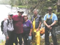
Colby, your thread has got me wanting to go back to Alaska! Now that we are retired, and can take as long as we want, we can do it right! Here is one of my favorite photos (a vivid memory actually, we were kind of beaten down at this moment, you can see see it in Patty's "look"!) from our 2006 cruise, it is entitled "The Hike from Hell at Meyers Chuck." Sam and his 2017 flotilla stopped here too!

s_of_the_Hike_from_Hell_Meyers_Chuck_6_19_06.sized.jpg

Pictured: Dave Olson, Pat and Patty (Daydream), David McKibben (Anna Leigh) and Alan Olson.
 
Pat, if you want to head up there next summer, and be joined by another boat, Let me know! I'd even consider starting out in the San Juans if that was your choice! :D But ideally prefer to spend time in the Alaska portion. I have all the time in the world, retired also. Where it gets tricky is the part about being married to a still working wife, and not really wanting to be a part for an entire summer. Ideally she will be able to fly out and join me for a few weeks at a time. Colby
 
colbysmith":2hvjpk9a said:
Some thoughts have recently come to mind. Fuel and Dinghy. I believe my current fuel provisioning is about 100 miles. (Loaded CD22, 40-42 gallons full). I suppose I should "measure" what I'm really getting, as this is just a guestimate... Also, currently I do not have a dinghy, or any other secondary watercraft. Would it be foolish to consider this trip without a dinghy?

Our first AK trip in 96, we towed our CD22 to Prince Rupert and spent two months on the water. We did not know what our fuel range was, but found out by running it nearly out, then watching how many gallons it took to get to each mark on the gauge. I'd suggest this would be worth doing. Traveling at 16-18 knots, our two cycle 90hp Yamaha gave about 3 nmpg with a heavy load. 58 gal tank gave about 175 nm max range.

A minimum of 130-150 range with some reserve would be wanted to allow you to get to most places in SEAK.

We carried a small cheap dinghy, but used it only a few times as it was a pain. It made seeing bears at Anan possible.
 
Thanks. That's good to hear about the Dinghy. And the fuel. I'm heading up the Chicago River middle of this week, (Starting downstream of Joliet about 8 miles, on the Des Plaines River) so think I'll get a good idea of gas usage at slower speeds. I'll start monitoring my fuel usage more the next longer cruises I take at various speeds to see how I'm really doing. I suspect it might be wise to carry some extra gas, and I'm thinking two 5 gal jugs may be appropriate. But I also want to watch the weight in the boat. Colby
 
Running rivers to get fuel usage is going to be a problem because of current. At low speed this can have dramatic effect on fuel consumption.
 
Just came back from our Chicago River trip. Running speeds anywhere from 5mph to 18 mph, and even a short time up at 25 mph. And while there is some current in the river, we went both ways, so I believe it's still a good average, and I'm sure with an Alaska cruise, there are tidal currents and all. Anyway, 150 statue miles, 39 gallons of fuel, so 3.8 mpg is what I figure. My boat topped off carries 42-44 gals of fuel, so that doesn't leave me with too much reserve. Colby
 
thataway":7whknax5 said:
Running rivers to get fuel usage is going to be a problem because of current. At low speed this can have dramatic effect on fuel consumption.

This was dramatically seen in my summer on the Yukon. The man with a 5 horse used more gas to go up river than those with 50-100 horse power.
 
colbysmith":10dp1g6v said:
Just came back from our Chicago River trip. Running speeds anywhere from 5mph to 18 mph, and even a short time up at 25 mph. And while there is some current in the river, we went both ways, so I believe it's still a good average, and I'm sure with an Alaska cruise, there are tidal currents and all. Anyway, 150 statue miles, 39 gallons of fuel, so 3.8 mpg is what I figure. My boat topped off carries 42-44 gals of fuel, so that doesn't leave me with too much reserve. Colby

Yes, there are currents, and in a slow boat, you time your passages to correspond with a current in your favor. If you do it right, you can double your range, by going slow, with the current. I am a little surprised that you 2007 only holds 42 to 44 gallons. In my 2006, after I had sucked the tanks dry with my polishing pump, I was able to put a little over 24 gallons in each tank. If course your running attitude will make some difference in the fuel pickups. Put two 5 gallon cans of fuel--cover the kicker/dinghy motor, generator, plus emergency reserve. You should be able to get 200 miles in a 22--especially working the currents.
 
As to guessing about fuel consumption, you might check out the Digiflow 6710M (micro). I bought one, but before I could install it, I found a Faria fuel flow meter (now out of production) that was made for boats and fits a 2" dash hole. The Digiflow looks like generic lab equipment, but the display could be placed somewhere out of the way. Or, you could use it to get flow rates at different rpms, calculate your max efficiency, and then stash the display out of the way and just use it for accurate total fuel usage.

Not all Digiflow models are rated for fuel and the micro model is available in a variety of different fittings and metrics (liters per second, gallons per minute, etc.) All can be converted with some math, but check to see if you can find one that has your preferred measuring scheme. There is one rated for fuel with a 1/4" hose barb. Mine shipped from Taiwan through Germany for some reason. Prices are also all over the place. I paid $32 for mine. I'd like to try it, but the Faria is working and looks good at the helm.

Mark
 
Actually I'd love to get the electronic transmitter for my Merc EFI 4 stroke that would allow my Garmin chart plotter to read all the fuel and tach information.
 
Just bringing this thread back to life and wondering out loud if anyone else would be interesting in joining me on a trip in SE Alaska next summer? As I read thru this thread again, I realize there is a lot (A LOT) of information out there regarding boating the Inland Passage and SE Alaska. So far what it boils down to is I really want to take my boat up there next Spring, but very leery of spending a lot of time solo. (My wife would fly out to join me for 3-4 weeks, but the rest of the time I would be solo on the boat.) What I'm thinking so far is that I would just go ahead and trailer all the way to Skagway. It's only 2 days farther than Prince Rupert anyway, and then I'm not having to do any major open ocean crossings. And I enjoy the drive as well. I would plan to spend at least a month or two on the water. Somewhere around 6 weeks sounds about right for just being in SE Alaska. I really haven't formed any kind of itenerary yet. Thinking I'd plan on launching in Skagway the first day of June, then pull out 6 to 8 weeks later. Colby
 
then I'm not having to do any major open ocean crossings.

No major ocean crossings from Prince Rupert. Not sure of what road route you would be taking. If taking BC Highway 37 (Cassiar Highway) there is the Hyder/Stewart cut off, and several nice lakes along the way. Highway 37 is narrow. Not sure it is an easy 2 day drive...but we did all of that upper area with an RV. From the Lower 48, and coming from mid USA there are many choices of highways to take if you are going all of the way up to Skegway. But probably a bit more risk to the truck with the Alcan. We had gone up to AK on the Alcan thru Dawson Creek, and came back via the Cassiar. Both were interesting, and I probably would suggest doing that. I thought the Cassiar was more scenic--the Alcan more historic.

I can sure understand that it would be a lot more fun with another C Dory. Alaska is an area to be shared--no way that Rosanne can get the entire summer off? Spend as much time as you can up there! Stay on the "inside reaches" to start with--especially if you are solo. There are always plenty of other boats around. No so going outside as Jay and Brent have done. When we went outside--from Elfin cove down to Sitka--we didn't see another recreational boat. There were a few fishing boats which we enjoyed. (Marie always had fresh cookies or bread to trade for fish, crabs etc--plus a great way to break the ice, and meet some very interesting people.)
 
Thanks Bob for the additional info. I thought there was at least 40 miles of open ocean crossing if going from Prince Rupert? I have driven the Alcan several times, but it's been a while. I first drove it up from Sacramento when I was stationed there in the USCG. That would have been in 1987. Drove to Fairbanks I believe, then back down to Haines to take the ferry over to my new station in Kodiak. After a year in the USCG there, I got out for the airlines, but shipped the car and flew. Then maybe 20 years ago, we took our motorhome from our home here out to Alaska. A month vacation, 9000 miles.... would have been much better to have had two months. We drove 400 miles a day, and only stopped in three or four places more than one night... Going up next summer, I'd likely go ahead and cross by Minot ND. That would be the shortest distance. I'd then stay on the Alcan until the cutoff to Skagway. Road wasn't all that bad back then, and I am assuming it's all paved now. If someone else wanted to join me and use Prince Rupert as our starting/ending point, I could still do that. But for now, Skagway just seems to be the best option. Thanks for referencing Jay and Brent's travels "outside". I like the idea of seeing other boats, particularly if I am solo. No, Rosanne can't get the whole summer off. I was thinking she'd only get a few weeks, but she did say she can work it to get about a month off. That would be great and allow her to see a lot more. I have no problem staying a bit longer due to the travel time to get there. Not always easy to plan long vacations with one spouse younger and still working, unless willing to do some solo stuff. But one thing I learned from losing my first wife at an early age, life is short. While I have the opportunity now, I may not later... This is just one of those things on my bucket list, and I may not be able to do it when Rosanne does finally retire. I think just limiting the travel to SE Alaska this time, I can probably see quite a bit in 4-8 weeks time. And even add a few more weeks on if I need or desire... Colby
 
Colby,
We'll talk about it at the Miss. gathering. But it is about 20 miles from Dundas Island lee to Duke Island Lee. You can get into Foggy bay before then. I would not really consider it "open ocean" anymore than going to Catalina is open ocean.

If you watch the weather it should be fine. We fished too late one day off the Northern tip of Duke Island, and had to fall in behind a trawler when going back toward Foggy Bay, going South in the c Dory 25--the next AM it was smooth as glass going to Prince Rupert.

The total distance is about 100 nautical miles from Prince Rupert to Ketchikan. We would stop at Dundas then Foggy Bay, and then Ketchikan in the Cal 46, doing 6 to 7 knots. Easy one day trip in the c Dory.
 
Hi Colby,

We are on our way across the Dixon Entrance, from Ketchikan to PR right now. This is our 30th crossing, counting both directions. 83 nm by the shortest route. Wait for the right weather and it's no big deal. Consider wind vs tidal current when you analyze the situation.

Running down Lynn Canal from Skagway can be more difficult.

Lots more detail I could offer, but not right now.
 
Back
Top