136-foot tug grouded on Bligh Reef PWS AK

breausaw

New member
This is absolutely insane! The only passable excuse this tug can have for running aground is loss of power, and additionally not having the ability to drop anchor.
I don’t care how bad the weather was out there, how thick the fog is, how saver the sea state was. There is absolutely no excuse for a well equipped vessel of this type running aground on one of the most well charted recognized marine hazards in Prince William Sound….period!!!
:x
Fuel tanks ruptured and leaking….
http://www.adn.com/news/alaska/story/1068799.html

It’s really going to be interesting to see how this plays out. I knew a guy who was relief skipper on one of these tugs, they are loaded with redundancies….someone must have fell asleep at the wheel or something…


Happy holidays to everyone

Jay
 
I've been to that marker a couple of times and using Coastal Explorer, with the NOAA charts I have found the actual reef offset some from the chart position. I find quite often in PWS that the chart location and the GPS position don't coincide. In other words, the land is in the wrong place and not by a few feet, but by 100 or more feet. Given the amount of metal on the bottom around Bligh Reef the best way to find it may be a magnetometer.
 
That rock is just a few miles from one of my favorite halibut holes. :cry And they gave up trying to retrieve the oil from the slick!

It seems to me that any boat with a GPS can waypoint the correct location of the reef and even set up a warning when approaching it.

There are so many ways to not run into that thing. It's going to be interesting to find out just what happened.

But Merry Christmas anyway.

Pat
 
Hey you boozoos with all of the latest state of the art instruments........there is a real big rock there...dduuuhh.
And it will "hurt" your boat as well as your reputation.
Incredible..............
 
Some good news. Report says they only lost 100 gallons of diesel. If that's the case it should be about gone by now. Surprizes me the liberal media isn't measuring it in pints. It would make a better story.
 
Diesel, as this card-totin' Dem from 1966 knows, is as harmless a hydrocarbon-based material as you can spill in a marine environment, relatively speaking. Here's hoping hydrocarbons avoid everybody's waterways, irrespective of yer political leanings. Oysters a la Texas tea ain't anybody's favorite.

On the coast of Oregon, the toxin du jour affecting the bivalves is PSP-affiliated, followed shortly by domoic acid. Natural, natural, natural, and highly toxic.

Poisons don't have any politics.
 
tpbrady":2eynbxqc said:
I've been to that marker a couple of times and using Coastal Explorer, with the NOAA charts I have found the actual reef offset some from the chart position. I find quite often in PWS that the chart location and the GPS position don't coincide. In other words, the land is in the wrong place and not by a few feet, but by 100 or more feet. Given the amount of metal on the bottom around Bligh Reef the best way to find it may be a magnetometer.

Maybe check the survey datum your GPS is set on?

Many of the early surveys and early charts were done in "NAD27".
Most GPS units are set on "WGS84" or "NAD83" - which is often off by 100 or 200 feet from the older charts. Most GPS units will let you change the datum to correct for this.

And if that tug was knowingly navigating that close to a known reef, they were taking big unnecessary risks.
 
John,

That was my initial thought also. I've tried switching datums and it doesn't seem to make much difference. I've also compared it to my Lowrance with the Navionics chip and they both will show I'm on land when I'm clearly in the water. The error seems to at least be consistent.
 
A quick check revealed that my friend who skippers one of these Crowley tugs is off duty this month! I agree that that these skippers are very careful. I'll find out the details when I get back to Pensacola, and talk with my friend. Doesn't seem like much excuse for that happening. But all manor of vessels do run aground, even with all of our modern navigational gear...
 
My next door neighbor is Captain of a Crowley Tug and typically goes from Jax to Puerto Rico. He recently had and incident where his tow barge took out a mile marker in the Saint Johns and it was quit and investigation. Like Bob I'll talk to him and see what his take is on it. I expect it will be the talk of the company for a while.
 
Coastguard and Crowley are staying hush on the matter for now. The CG monitors traffic throughout the sound, so wondering if they are under internal investigations. The proverbial dung will eventually hit the fan, were it lands the flyers will gather.

Jay
 
I looked at the picture in the article. I find it hard to believe that 1000 ft ships go out through there. If they don't go out that way, why was the tug even looking for ice there. It seems kind of pointless to me.
 
Dave,

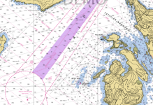
I just checked on my chart program and Bligh reef is approx 1.25 miles from the nearest edge of the traffic separation lanes.

All inbound tankers could pass that close and outbound tankers, (the full ones) pass at about 3 miles.

The photos show the tug anchored in a nearby cove away from the traffic separation lanes.
 
Larry,

Thanks for the shot of the chart.

Here's the deal: The open channel to the northwest is the bay from which icebergs from the Columbia Glacier come. When the tide and the wind are coming from that area, the 'bergs float out into the shipping channel. I've seen them grounded in the shallows in the Tatitlek Narrows in the late summer, too.

The tankers leaving the pumping station at Valdez do so under their own power. They have two tugs pulling on their sterns to keep them straight. If a heavy side wind were to push the tanker toward the reef, it's the tugs' responsibility to get the ship headed away from danger. It takes quite a distance to maneuver the ship against the wind using just the tanker's power and the pull of the tugs. That shipping lane gets to looking mighty narrow when it has a tanker in the middle attached to two spread-out tugs in tow.

I think it makes sense that the tug was running close to the reef to look for grounded bergs. They can pile up and extend into the channel for quite some distance. And when the tides and wind shift, they just wander back into the shipping lane. So the guys have to not only see what's there now, they have to predict where it will be when the tanker comes through.

I've worked my way through the ice in Glacier Bay in the summer with the C-Farer and I'll tell you, there are mighty few channels to follow when the ice is bunched up.

It's a tough job that requires a meticulous approach. But I still don't know why he got that close to the reef when he wasn't working with a tanker.

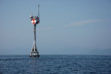
I can see the beacon for Bligh Reef from one of my halibut fishing spots. It's hard to miss.

Happy New Year to all and safe boating.

Pat
 
WOW... just a quick read here, and it looks like that Tug Captain and me are the only two on this site that have ever ran aground....hit a buoy or anything else. I am glad I no longer stand alone.

Wait.... it does seem I recall when starcraftom was doing a sea trial in his C-dory boat for Jim and the Blond(Joan)....he even showed them ....well.... that you could park it on the bank if you needed, but that was not a grounding either.

Byrdman
 
Byrdman":2pj4diwf said:
...it looks like that Tug Captain and me are the only two on this site that have ever ran aground....

Bad news, Patrick. I did a quick check of the memberlist, and the tug captain is not on it. :mrgreen:
 
From the rupturing of 3 fuel tanks and a 4 to 5 foot section of keel being torn off its obvious the tug was underway when it fetched up on the reef.

When the dust settles my guess is the watch crew probable waited too long before making a crucial navigation maneuver coupled with a fatal panic maneuver.

Just a guess and something to occupy the mind while winter agonizingly materialized to spring...

2 weeks in Hawaii will help :smiled
 
Just for interest,

The navigation light on Bligh Reef is 59ft above water with a visibility of 9 miles. In addition the marker has a racon, which is a device that sends an identifier when swept by a radar beam.

The marker shows up as a morse code like symbol on the radar screen of the ship or boat. It is a positive identifier of which bouy or marker the radar is seeing.
 
Back
Top