WXTide PC-based tides & currents

Tortuga

New member
Anyone use wxtide? I found it after looking for a graphical tides/currents interface. It's free -- and using NOAA tidal harmonics. It looks to be accurate when I crossreference with the NOAA tides and currents page.

I like it a lot -- easy to download and easy to use. (I have no commercial interest/connection with it -- I'm just too cheap to pay for something that is easily available -- and based on data and algorythyms supported by our tax dollars).

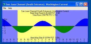
Once loaded it will open to a simple graph for whichever site you last viewed -- either tide or current. The sample below is the current graph for the South Entrance San Juan Channel. You might see the small + sign on the graph at 3:00 pm (it's hard to see and should be bigger) -- that's the time I took the snapshot of the graph.
wxtide.jpg

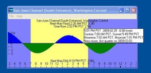
If you click anywhere on the graph it gives you the current prediction for that time:
wxtide2.jpg

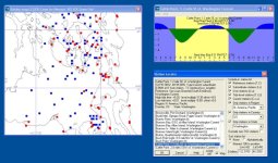
The best part of it, though, is the graphical map location finder that allows you to view a geographic region (using the mouse buttons to navigate), and select the current or tide location you want (the NOAA site requires that you know the location of all the sites and select from a menu -- this is much faster. Red for tide and blue for current (you can also view only currents or only tides)

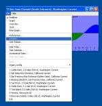
Click file, then location:
wxtide3.jpg

This is what comes up:

wxtide4.jpg

It's great for planning -- so next time I'll avoid the screaming ebb in Baynes Channel. A lot easier than trying to see tomorrows slack on my GPS software. Course... as the wxtide website says... always check your final current/tide data at the noaa site:
http://tidesandcurrents.noaa.gov/curren ... d2.html#OR

Anyone using something that may also be worth examining? Wxtide seems to work well for west coast sites I've explored -- I assume it works across north America.

As I said, I have no commercial interest in it -- just the one I came upon that seems to work well. Pretty simple program.

Matt
 
Thanks, it looks like a good program for planning. I usually take a Mac on the boat--and this program is not compatible (and the developer does not plan a Mac version)

I end up using the chart plotters built in chart and current features. It worked well for us in the PNW this last couple of summers. Also there are both Capt Jack's tables and Ports and Passes which work well in the PNW.

I have never worried about the tides or currents in the S. Calif. area, but I sailed out of Long Beach 99% of the time.
 
Looks like a great site. i have been using the noaa and tide predictor, both good sites but not up loadable. I also really like BIS It allows you to see tide, current, wind all at the same time or separate for a large area not just on station. great for planing. Only for the Puget sound and islands.

What I have been looking for is a down load or online site where I can trip plan and save way points for free. thats right free. I have raymarines ray planner but I have to buy the 75 dollar chip reader to use it. I'm just to cheap and cant spend $75 on a $5 card reader just because it says raymarine on the side. Can't do it and won't and you cant make me. I don't need the trip planner to be down loadable, or the way points to be transferable. I just need to be able to sit at home and plan trips then print out the results. I want to compare different routes to see what is really the shortest or estimate distance and fuel burn. so any ideas.
 
starcrafttom":id1hfs9n said:
I have raymarines ray planner but I have to buy the 75 dollar chip reader to use it. I'm just to cheap and cant spend $75 on a $5 card reader just because it says raymarine on the side. Can't do it and won't and you cant make me. I don't need the trip planner to be down loadable, or the way points to be transferable. I just need to be able to sit at home and plan trips then print out the results. I want to compare different routes to see what is really the shortest or estimate distance and fuel burn. so any ideas.

Tom, I'm pretty sure that all you need is a USB CF (Compact Flash) card reader -- you can get them on Amazon very cheaply. I will double check when I get a chance as I have RayTech installed on my Mac and I am pretty sure I used a generic card reader to read my Navionics chip.

Bob, I am using VMWare Fusion to run Windoze software on my Mac. Pat Anderson has used Parallels and the Open Source alternative whose name escapes me at the moment. It's an easy way to have your cake and eat it, too. I am going to try out that tide software.

Warren
 
With the CF Platinum cards, the paperwork says something along the lines of: you may lose the data on the card if you insert it into your card reader. Because of that, I've never tried. A guy at Consumer Marine told me not to do it.

Jim
 
I have used the WXTides program for years. In fact we used to launch our Boston Whaler where the no-go for launch/retrieve was a 10' tide. I configured a location specific for our launch site, and never had to worry about when to launch or retrieve. I have never found it to be more than 0.1 foot in error wherever I have used it.

As to the Raymarine Raytech software and the Navionics card, I too have not used my Navionics card due to the same dire notice. I sure would like to use it though. I downloaded all of the NOAA charts for the PNW, and use them in the Raytech software for planning, along with the Raymarine file conversion utility, PCWaypoint.
 
Warren,
Good point--I have avoided the Windoze on the Mac so far. My 10 year old office computer running 98 started having problems in the hard drive--and I pulled all of my backups--and put all of the data on a new computer running Vista---when I finally got all of the various drivers down loaded etc--2 days worth--it is OK--but still way slower than my MacBook....
 
ok so I can down load chart to ray planner? how is that done? and yes I can barely type on these dam things. I always have a hard time down loading anything. I have tried to down load "ctide' to my phone 10 times and have never got it to work. It down loads but does not work. drives me crazy. Seems if I can't see the part's I cant fix it.
 
thataway":35yyipgs said:
I have never worried about the tides or currents in the S. Calif. area, but I sailed out of Long Beach 99% of the time.

That's been my experience as well growing up sailing out of MDR. But I was cured sailing in San Francisco Bay... trying to make way from Sausalito to Fort Point in a max ebb tide :shock:. When I taught sailing in Berkeley we had students return from the Bay telling stories of Alcatraz Rock suddenly rushing toward their boat.

Luckily, back in Ventura we have trained our terrestrial landmarks to stay where we left them!

starcrafttom":35yyipgs said:
... What I have been looking for is a down load or online site where I can trip plan and save way points for free. thats right free. I have raymarines ray planner but I have to buy the 75 dollar chip reader to use it. I'm just to cheap and cant spend $75 on a $5 card reader just because it says raymarine on the side. Can't do it and won't and you cant make me. I don't need the trip planner to be down loadable, or the way points to be transferable. I just need to be able to sit at home and plan trips then print out the results. I want to compare different routes to see what is really the shortest or estimate distance and fuel burn. so any ideas.

I use Maptech's Offshore Navigator -- which is an old version of Chart Navigator. You can download Chart Navigator Viewer for free HERE. I don't know if you can save waypoints in the free version. Then, you can download NOAA RNC (rastor) Charts -- which are essentially digitized paper charts -- for free HERE. It'll take some time to figure out how to configure them -- but it's well worth it. Plus, the RNCs are updated weekly, so you can just update your charts before trips. PM if you get stuck.

DennisB":35yyipgs said:
... I have never found it to be more than 0.1 foot in error wherever I have used it.

That's good to hear... adds some additional confidence.

starcrafttom":35yyipgs said:
ok so I can down load chart to ray planner? how is that done?

I don't know if this is what you're looking for, but the NOAA Charts are available here:
http://www.nauticalcharts.noaa.gov/mcd/ ... eement.htm
and WXTide is available here:
http://www.wxtide32.com/

Matt
 
Doryman":xq4a11zs said:
Tom, I'm pretty sure that all you need is a USB CF (Compact Flash) card reader -- you can get them on Amazon very cheaply. I will double check when I get a chance as I have RayTech installed on my Mac and I am pretty sure I used a generic card reader to read my Navionics chip.

Tom, I was wrong. L@@K HERE for an explanation from Ben Ellison (Panbo). Short version: Windows sucks.

Warren
 
Back
Top