Jason go to [urlhttps://webapp.navionics.com/#boating@5&key=%7Df%60%60Htz%60yV]Navionics web app of the Oregon/Washington Coast/and Straits of Juan de Fuca.[/url]
The wind and waves can be high, and not as predictable as those on the East Coast. The majority of weather is out of the North West, so this entire coast is a lee shore with very few harbors of refuge.
I went to "Windy.com" and looked to see what the conditions were on mid voyage for this trip currently. 9 knots out of the SE (unusual),
against two sets of swells: (representing two different storms in the Pacific--one in the Northern portion, the other in the mid Northern, but South of this area.) Average swell is 7' at 9 seconds. But in some places 12' at 5 seconds. When you adding back wash from the shear cliffs, and against even a mild breeze, it can become rough quickly.
Now tomorrow at about this time the wind will be 31 knots out of the SE with some waves up to 12 feet. (I have run into SE storms when going down the coast in both spring and fall.)
There are some difficult passages on the East Coast also--would you go out in a Nor Easter? There can be some very difficult bars, and passes, all along the coast depending on the weather. For example anything North against the Gulf Stream current of 2.5 to 3 knots can get very rough. I have gone up the East Coast both totally offshore, and in the ICW--both can get rough enough that you don't want to do it in a C Dory 22--but as noted, there is the ICW, and many more harbors. Much of the East Coast is gradual topography at the shoreline, vs cliffs and rocks on the West coast--refer to the * on the chart.
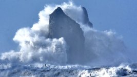
Near La Push during a storm:


