journey on
New member
- Joined
- Mar 3, 2005
- Messages
- 3,599
- Reaction score
- 0
- C Dory Year
- 2005
- C Dory Model
- 25 Cruiser
- Hull Identification Number
- TBD
- Vessel Name
- journey on
As I’ve mentioned before, openCpn is a free open source PC navigation program, using among others, the free NOAA charts, either raster (traditional) or vector (ENC.) In addition, since it’s open source, people are writing enhancements, such as a radar overlay and AIS. Since using a PC for navigation is or interest, I tried openCpn. It worked so well that I continued to update Journey On’s radar. And herein lies my story. BTW, I make no claim as to originality. Several C-Brats are using openCpn and others have PC radar. But I did get it to work.
First, one needs to get a radar dome that’s compatible with the plug-ins that have been developed for openCpn. My old JRC radar, which did well by me, just did the RF transmission and receiving in the dome, sending the signals down to the display for range/direction calculations and the display. All new radars perform all the calculations in the dome and send a complete picture down to the display. And 2 brands send that data down using Ethernet, a commercial data transmission standard: Garmin and Lowrance. Note that all PC’s have an Ethernet connection. openCpn plugins (or subroutines, as us of an older generation call them,) are available for the newer version of these radars.
Garmin and Lowrance build different radars. Garmin uses the pulse method of sending out a burst of frequency and measuring the time of flight. Lowrance sends out a frequency sweep (chirp) and correlates the return. The latter is more efficient and gives a better signal to noise ratio, allowing lower power. Both radars are very good, but since Journey On needs radar information at less than 2 miles, and this is where Lowrance shines, I bought a Lowrance 3G. the signal processing description is here: http://en.wikipedia.org/wiki/Pulse_compression. This describes the pulse and chirp signals, so one can see how pulse compression gives you more gain. I think of it as frequency matching, so you have a longer correlation time.
I’ve been working to get openCpn to display the Lowrance 3g image. I finally got it working in the driveway and this week took it down to San Diego Bay. I’m thrilled, and here are some screen shots.
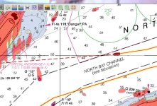
The first shot shows Journey On headed out of San Diego Bay. The course is stable and you can see the correspondence of the radar with the chart. Notice the radar plot over the bouy markers. That 3G certainly displays detail under about 1 mi range. Those radar signals above the Special Anchorage note are indeed boats moored.

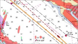
Next, is a shot of downtown San Diego Bay, next to North Isle. Again note the correspondence of the bouy location and the radar response. Some of those radar signals are kayaks, fishing in the middle of the bay, dodging tugs, sailboats, etc.

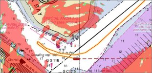
Finally, Glorietta Bay. The picture is certainly more detailed than the JRC I was using. The boats and the shoreline clearly show. Judy is steering the boat, turning to follow the channel and it takes a few seconds for the radar overlay to settle down. Remember the radar is bolted to the boat and turns with it; the chart just stays pointed North.

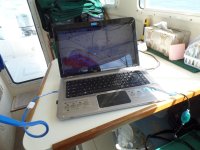
Finally a shot of the computer set up, just 3 wires: power, ethernet and GPS

If one wants to read about how the radar overlay is installed, here’s the Cruiser Forum threads where it’s discussed in gory detail: http://www.cruisersforum.com/forums/f13 ... 81-11.html and http://www.cruisersforum.com/forums/f13 ... 23167.html
I’m using the latest dll (plugin,) version v 0.40529 which may be downloaded here: http://opencpn-navico-radar-plugin.github.io/
Anyway, I’m set to go up to Canada next month.
Boris
First, one needs to get a radar dome that’s compatible with the plug-ins that have been developed for openCpn. My old JRC radar, which did well by me, just did the RF transmission and receiving in the dome, sending the signals down to the display for range/direction calculations and the display. All new radars perform all the calculations in the dome and send a complete picture down to the display. And 2 brands send that data down using Ethernet, a commercial data transmission standard: Garmin and Lowrance. Note that all PC’s have an Ethernet connection. openCpn plugins (or subroutines, as us of an older generation call them,) are available for the newer version of these radars.
Garmin and Lowrance build different radars. Garmin uses the pulse method of sending out a burst of frequency and measuring the time of flight. Lowrance sends out a frequency sweep (chirp) and correlates the return. The latter is more efficient and gives a better signal to noise ratio, allowing lower power. Both radars are very good, but since Journey On needs radar information at less than 2 miles, and this is where Lowrance shines, I bought a Lowrance 3G. the signal processing description is here: http://en.wikipedia.org/wiki/Pulse_compression. This describes the pulse and chirp signals, so one can see how pulse compression gives you more gain. I think of it as frequency matching, so you have a longer correlation time.
I’ve been working to get openCpn to display the Lowrance 3g image. I finally got it working in the driveway and this week took it down to San Diego Bay. I’m thrilled, and here are some screen shots.
The first shot shows Journey On headed out of San Diego Bay. The course is stable and you can see the correspondence of the radar with the chart. Notice the radar plot over the bouy markers. That 3G certainly displays detail under about 1 mi range. Those radar signals above the Special Anchorage note are indeed boats moored.

Next, is a shot of downtown San Diego Bay, next to North Isle. Again note the correspondence of the bouy location and the radar response. Some of those radar signals are kayaks, fishing in the middle of the bay, dodging tugs, sailboats, etc.

Finally, Glorietta Bay. The picture is certainly more detailed than the JRC I was using. The boats and the shoreline clearly show. Judy is steering the boat, turning to follow the channel and it takes a few seconds for the radar overlay to settle down. Remember the radar is bolted to the boat and turns with it; the chart just stays pointed North.

Finally a shot of the computer set up, just 3 wires: power, ethernet and GPS

If one wants to read about how the radar overlay is installed, here’s the Cruiser Forum threads where it’s discussed in gory detail: http://www.cruisersforum.com/forums/f13 ... 81-11.html and http://www.cruisersforum.com/forums/f13 ... 23167.html
I’m using the latest dll (plugin,) version v 0.40529 which may be downloaded here: http://opencpn-navico-radar-plugin.github.io/
Anyway, I’m set to go up to Canada next month.
Boris
