OK, here's my 2 cents. We've used laptops for navigation and piloting to about a decade. Used them in Mexico, So Pacific, Alaska, East Coast, Great Lakes, etc. Always worked well. Quit using paper charts years ago, except for overall planning. And Bob's correct as to lifetime, since we're on the third one. Dogon Dory's correct, about every 3 years, we have to "upgrade." The abuse those computers can take is remarkable.
Tried about 4 programs: Capn, Maptech, Fugawi, and one other I can't remember. They all appear to be about the same, though Capn will plot a great circle route for you. What is important is that you learn how to use the one you have, for route planning (navigation,) following the course (piloting,) developing routes etc, etc. A lot of people I've talked to have the programs, but don't take the time to really learn how to use them.
We also have a chart plotter, a small one with GPS, radar, etc. So for short term piloting, I use a reference set of waypoints I've developed on the computer, and follow them. This allows me (the helmsman) to compare where the chartplotter says to go with what's really out there. By the way, we have C-Map, and I'm happy with them. If someone likes something else better, OK. One advantage of the computer, is that when you don't have a chip for the area you're going through, it's easy to copy a CD and use it on the computer. We didn't have a chip for the Canadian canal, and someone nicely gave us a CD.
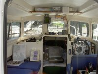
As to placement, the chartplotter is overhead, and I can glance up to see if we're on course, whilst steering. The computer is on the table, and Judy does the navigation. She seems to love to tell me where to go. She will check off the buoys, turns and other routing stuff, while I try (with the autopilot) to stay on course and not hit anything. Works well. Sometimes we have a spirited discussion as to what island that really is.
GPS's are cheap, and having one dedicated to the computer and one for the radar/chartplotter makes sense. Light houses are now an anachronism, and I noticed that buoys are not a prevalent as they used to be. Paper charts are no longer required for commercial ships. Also not all computers have serial ports these days. So having a laptop is almost mandatory, but make sure that you can connect the GPS to it. They're cheaper and can do more that a 12" dedicated chartplotter. Like get the e-mail and weather.
Boris

