Earl

ken 120

New member
Sitting on the coast of South Jersey on a barrier island I am following Earl's forward motion. Looks like he is headed for the outer banks and then impact/effect the Middle Atlantic and New England States.

As your area is impacted would like to hear from the Brats in terms of the impact- be nice to hear from other then the media.

Ken
 
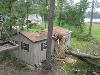
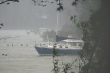
We had ISABEL and then ERNESTO here near the Bay at the mouth of the Potomac. Lost lots of trees, big trees and a shed during ERNESTO. Water 2' over the top of my pier and halfway up to where the house now is.


Ernesto_Damage_001.sized.jpg

12x24 shed made into two 12x12 sheds with a 24" oak tree!

06_hurricane_006.sized.jpg

Water two feet over the top of the pier during Ernesto, 65mph winds for over 4 hours. No damage to the CD22 or Gloucester 22. Amazing!


This one, unless it does something they don't expect it to, will be quite a bit tamer. Will advise, supposed to be off the coast here mid day Friday.

Charlie :disgust
 
I'm watching it like a hawk too....for us in Boston it's supposed to hit late Friday night. If the forecast continues to keep the brunt of the storm at the Cape and farther out, Napoleon will ride on her mooring but I will be paying attention in case I need to take additional action. If the storm steers to a closer shore hit I am prepared to haul it out.
 
Captains Cat":fhybm3xu said:
Don't wait too late Matt, you won't be the only one at the ramp...

Charlie

I hear ya Charlie! Fortunately we have a private ramp at the yacht club but it would still be a long wait I'm sure.
 
We're across from Cape Lookout/Ocracoke on the mainland. Boarded up the front door and the attic vents (old house/style - wooden louvres) at the gables. 100mph wind moves sideways and when filled with water, it makes a mess of ceilings/walls, etc. :shock:

Wind Speed is 21 knots (NE @ 40 degrees); Gusts of 26 knots; Barometric 1012.4 mb (Station CLKN7 @ Cape Lookout)

Image of the Day from NOAA:

http://www.nnvl.noaa.gov/images/high_resolution/507_Earl-9022010-1920.jpg?ref=nf

Link to buoy Real-Time Data (if interested) (CORMP)

http://www.cormp.org/

At 11 a.m. EDT on September 2, Hurricane Earl had maximum sustained winds near 140 mph. It was 300 miles south of Cape Hatteras, NC, and 765 miles south-southwest of Nantucket, Mass. near 30.9N and 74.8W. It is moving north at 18 mph and has a minimum central pressure of 932 millibars.

Source:
http://www.nasa.gov/mission_pages/hurricanes/archives/2010/h2010_Earl.html
 
I was in Hugh when it rolled thou Charleston back in 90? get the hell out now. there is nothing in your house worth dieing for, nothing!! You do not have the power to save your home and other property other then take it with you. You serve no purpose what ever by staying. pack up now and take a week vacation in land 400 miles. leave before the rush.
I have never understood folks that are stupid enough to say " we are going to brave it out and protect our homes" what morons. Its a hurricane ,your house is going to stand or not and nothing you do is going to change that. if you are in the home when it gets washed away you are a stupid dead person, if your house makes it you are a luck stupid person. Being in the house changes nothing. If you leave and the storm misses then you got a few days away vacation, nothing loss. by staying you endanger not only your life but the life of those that have to rescue you. get out now.

for those that think I am being rude, you can not be rude enough to stupid people who have no concern for their own lives or the the lives of thier families. In the old days people died from hurricaines because they did not know they were coming, now its only because they were stupid enough to stay.
 
Thankfully it appears Fiona won't make it to the coast. Gaston however is a very real concern since it appears it will devlelop in a hurricane and it's track mimics that of Earl and most North American coastal cyclones. :amgry
 
Tom, you are abit over-the-top with your advice. There are more well-mannered and informed messages which could be constructed (don't you think?). We're not stupid people around here, we're rather well-informed and understand the conditions associated with these events. But, thank you for your obvious concern. :beer
 
it is concern that I have for others but some need a little kick to get going. other wise I would not have to sit and watch losser after losser on t.v. talking about how they are going to "brave" it out. I have seen good people stay and put their famlies at risk for what? nothing but a house. I have seen what a big hurricane will do and its not pretty. If you are not there there is no chance of dieing.

from a web site about hurricanes.
The total death toll from Hugo was seventy-six.

Hugo was such a deadly and costly storm that it's name was retired and replaced with Humberto in the 1995 season.

none of these people needed to die if they had just left.
 
starcrafttom":26em0s4o said:
it is concern that I have for others but some need a little kick to get going. other wise I would not have to sit and watch losser after losser on t.v. talking about how they are going to "brave" it out. I have seen good people stay and put their famlies at risk for what? nothing but a house. I have seen what a big hurricane will do and its not pretty. If you are not there there is no chance of dieing.

from a web site about hurricanes.
The total death toll from Hugo was seventy-six.

Hugo was such a deadly and costly storm that it's name was retired and replaced with Humberto in the 1995 season.

none of these people needed to die if they had just left.

Tom,

You have a point but (just for the sake of arguing)... :wink:
1) If you are not there, you still have a chance of dieing (from other causes mostly with lower risks).
2) We can't always blame the victims - in many (probably even most) cases the deaths are at least partially due to poor decision making. However, some are almost always attributable to a lack of mobility (lack of a car, elderly etc). So I would say "most" of the deaths are avoidable as opposed to all.
 
Wow,
Did he mean loser after loser or losser after losser? :? Sounds like someone just polished off a couple energy drinks. I think I read last night that no one on Ocracoke had ever died as a result of a hurricane. For me I'd leave but for some they stay as getting back to barrier islands can be a problem. These are close knit communities and people who have seen a lot of these storms come and go. Tough bunch down there in those fishing communities. I hope what ever they decide to do that they stay safe and sound.
D.D,
 
here are some out takes from a case study on hurricane deaths. I like number four.

On Isle of Palms, a barrier island adjacent to Sullivan's Island, the mayor and several police officers were sheltering in a 2-story building which lay at an elevation of ten feet. As related in a story published in the St. Petersburg Times, they heard the following bulletin on the radio at 10:30pm the night Hugo made landfall:

"The National Weather Service has issued a storm surge update. It appears that the storm surge will be greater than anticipated. It is now expected to reach a height of 17 to 21 feet."

"Mom didn't raise an idiot," said the one cop with the most sense, and he convinced the others to get off the island. They left the island by driving at 5 mph through horizontal sheets of rain and hurricane-force wind gusts over the Ben Sawyer Bridge, which connected Sullivan's Island to the mainland. As they crossed onto the bridge, they passed over a large bump--the bridge and road bed were at different levels. Not good. While crossing the bridge, they could feel it swaying and straining, and heard the sound of metal, twisting and grinding and breaking. They made it, but only barely--minutes later, the hurricane tore the center span of the bridge from its connection on both ends, leaving it a twisted ruin in the bay.

In McClellanville, on the coast thirty miles northeast of Charleston, between 500 - 1100 people took refuge at the designated shelter for the region, Lincoln High School. Lincoln High is a one-story school, mostly constructed of cinder block, located on the east side of Highway 17, and was believed to be at an altitude of twenty feet. McClellanville is about 4 - 5 miles inland from the open ocean, but lies on the Intracoastal Waterway, so is vulnerable to high storm surges. Near midnight on the 21st, a storm surge of twenty feet poured into Bulls Bay just south of McClellanville, and funneled into the narrow Intracoastal Waterway. Water started pouring into the high school and rose fairly rapidly. Within minutes, people were wading around up to their waists, the water still rising. In the school cafeteria, many refugees gathered on a stage at one end, putting children up on tables. The elevated stage kept them above water; others floated in the water. Another group was in the band room, which had a much lower ceiling than the cafeteria. They had to stand on desks and push out the ceiling tiles for more breathing room, as the water rose within 1 - 2 feet of the ceiling. Fortunately, Hugo's storm surge peaked at that time, at about 16 - 17 feet (Figure 4), and the people sheltering at Lincoln High were spared.


Figure 3.Estimated storm surge (height above ground) as estimated by NOAA's storm surge model, SLOSH. McClellanville (upper right) received a storm surge estimated at 16 - 17 feet.

According to Dr. Stephen Baig, the retired head of the NHC storm surge unit, the back-story is this: To build Lincoln High School, which lies at an altitude of ten feet, the local school board used the same plans that were drawn up for another school that is west of Highway 17, and that IS at 20 feet elevation. Not only the same plans, the same set of working drawings. Those working drawings showed a surveyed elevation of 20 feet above datum (probably NGVD29). Apparently Lincoln High was constructed either without benefit of elevation survey or the plans were not annotated with its site elevation. When the Red Cross inquired as to its utility as an evacuation site, whoever looked at the plans saw the surveyed elevation at 20 feet. That is what the Red Cross published. That is why the school was a designated shelter. Since that near-tragedy, the Red Cross requires a new elevation survey for every potential storm shelter. I think that at the time this was discovered all the designated shelters also were re-surveyed, just to be sure that no similar Lincoln High problems were waiting to happen.

4) Luck. The 20+ storm surge deaths on the Bolivar Peninsula in 2008 from Hurricane Ike show that there are still plenty of stubborn, unlucky, or uneducated people who will die when a significant storm surge hits a low-lying populated coast. The storm surge from the next major hurricane that sweeps through the Florida Keys is likely to cause a lot of storm surge deaths, since many residents there are pretty stubborn about not evacuating.
you make excuses all day but in the end you have to leave. You have two days before this storm hits. Hugh was mere cat 3 20 hours before hitting as a 5 with 20 ft surge. all i am saying is that if you are informed you will leave. if you are informed and stay you are stupid. You cant be ignorant and informed. you are ignorant or stupid if you know a storm is coming and you don't leave. No wait if you know its coming you are informed and just stupid for staying. hey if any one can convince me they can save their house by just being in it I will apologize.
 
Dave, you don't know Tom. He always has an energy drink or two in his back pocket... :roll:

Now with the video he posted after having been out in the storm a day or so ago, one might think he'd not give too much advice not to put one's self into harms way... :lol:

Charlie
 
don't drink energy drinks, that stuff will kill you. almost as bad a coffee.

the video the other day is a good point and I put it there as a warning. I was STUPID for being out there. I did not take to heart the warnings, well the warnings where wrong and the wind was not supposed to get there until later in the day. I was planning on being off before 12. wind was fore casted to increase at 2pm. I should not have been there and you have to take the warnings more serious. If I had died It would have been because I was stupid. I lived because I was lucky and stupid. I made a bad decision that day. we should have left earlier from our protected spot or not have left at all. I thought about anchoring on the calm side of PNP but left anyhow.

when Hugh was coming I was ordered by my LT to stay in the barracks, at sea level, so he could keep taps on us. I explained in nice easy to understand words what a moron he was and left for a warm girlfriends apartment in Georgia. I came back after the storm passed. The Marines that stayed had no electricity, flooded rooms and MRE's for three days. They got lucky, I got laid, neither of which changed the storm at all.
 
Earl appears to be downgrading (at the moment).
Unfortunately, it's also reducing its forward speed from 18 knots to 16 knots.
Pressure has gone up from 943 mb to 947 mb (weakening).

Hurricane EARL (AL072010)
Advisory #34

--------------------------------------------------------------------------------

Advisory Information
Valid at: 5:00 PM EDT Thu September 02, 2010
Location: 32.5 N, 75.2 W
Maximum Wind: 100 knots (115 mph)
Wind Gusts: 120 knots (140 mph)
Moving: North at 16 knots (20 mph)
Minimum Pressure: 947 mb
 
Earl is tracking nearly directly North at the moment. It is located ~ 175 miles South of Cape Hatteras.

LOCATION...32.5N 75.2W
ABOUT 185 MI...300 KM S OF CAPE HATTERAS NORTH CAROLINA
ABOUT 670 MI...1080 KM SSW OF NANTUCKET MASSACHUSETTS
MAXIMUM SUSTAINED WINDS...115 MPH...185 KM/HR
PRESENT MOVEMENT...N OR 360 DEGREES AT 18 MPH...30 KM/HR
MINIMUM CENTRAL PRESSURE...947 MB...27.96 INCHES

Sustained winds have dminished to 115 mph (down from 140 mph). It is now a Cat 3 and expected to be Cat 2 during its approach to Cape Hatteras.

In Beaufort our High Tide is 2010-09-03 3:24 AM EDT 2.38 feet High Tide

STORM SURGE...A DANGEROUS STORM SURGE WILL RAISE WATER LEVELS BY AS MUCH AS 3 TO 5 FEET ABOVE GROUND LEVEL WITHIN THE HURRICANE WARNING AREA OVER NORTH CAROLINA

So, I add our tide 2.3' + 5' (maximum) storm surge and arrive at 7'3" above MSL on the coast. My house is at 12' above MSL. I don't think storm surge will be significant for me.

However, the problem for many folks will be the backing up of the water into Bogue Inlet, Albermarle Sound and Palmlico Sound where those areas are 1' to 3' above MSL. They may have some significant flooding in those areas as the storm surge moves inland into those Inlets. Of course, none of this accounts for waves. I've heard there have been waves of 50' at sea. However, as all waves generaly do, they break apart moving towards shoreline as their energy is subsumed.

There is another update (Advisory 35) coming out in ~5 minutes.
 
Back
Top