Best charts for Lowrance HDS-8 in the Puget sound region

rogerbum

New member
So, I now have my Lowrance HDS-8 installed and working. I looked at the base map by cursoring around to my favorite fishing spots and it was not at all adequate (not much depth contours). Then I installed the navionics 1XG chart (it came with the 8200C) and that provides an acceptable level of detail. So now the question is:
Is it worthwhile to buy the Navionics Platinum or Gold charts for the Puget Sound and/or west coast? I'd kind of like to see what extra detail I get for the $'s and it's a bit hard to tell from a few screen shots on the Navionics web site. Anyone with real life experience with these charts?
 
I have both (first got Gold, then moved it to the 22 and got Platinum for the TC.) You are welcome to take a look at what they look like. I would be reluctant to recommend/not to you because I am not sure what you are seeking. I will say that I am very happy with the Platinum and have others for Florida and Alaska. It is eye candy, but whether it has more actual data than Gold I am not sure. They do make it easier to see the seabed contours visually.

Warren
 
look into getting a fishing chip chart. 10x the depth contours and detail. its well worth the money. I have one for the raymarine and change it out when fishing from the gold.
 
starcrafttom":pgy82l5m said:
look into getting a fishing chip chart. 10x the depth contours and detail. its well worth the money. I have one for the raymarine and change it out when fishing from the gold.

I thought the fishing chip was only for freshwater lakes? I do know that the Platinum includes the fishing chip data now -- originally they shipped two chips, one for Florida (for example) and then a hotmaps chip for lakes. Now they ship only one chip that includes the fishing data.

Warren
 
Doryman":31l4iwv8 said:
starcrafttom":31l4iwv8 said:
look into getting a fishing chip chart. 10x the depth contours and detail. its well worth the money. I have one for the raymarine and change it out when fishing from the gold.

I thought the fishing chip was only for freshwater lakes? I do know that the Platinum includes the fishing chip data now -- originally they shipped two chips, one for Florida (for example) and then a hotmaps chip for lakes. Now they ship only one chip that includes the fishing data.

Warren
Warren,
That's my understanding also (as far a Navionics/Lowrance goes). I think I'm going to go over to Fisheries Supply and see if they will pop the Platinum+ chip for Puget Sound and Vancouver Island into an HDS unit so I can see what the difference is relative to what I see on the Gold US map.
 
I have personally not found the platinum worth the difference over the gold for my personal use. But then I use other information such as Active Captain on a computer or i pad. I don't find the photos to be of much help. In the Gulf coast there have been a number of changes on the bottom since the hurricanes, and I am not sure how up to date the bottom data is. It would a lot of research to build a new database.
 
starcrafttom":2eepwlpl said:
no I have a fishing chip for the sound. great for finding small pinnacles and points.

Roger, I will be very interested in your opinion of the Platinum details of the bottom of Puget Sound. Maybe Fisheries can tell you if it is the same as what is in Tom's chip. Another source of info that I have found to be quite useful about this kind of thing is our own Captain Matt who sells them. Be sure to check his prices before buying.

Warren
 
the differance in the platuim chip is not the amount of bottom information but the amount of navagation info and pictures. the fishing chip has no nav info and vastly more bottom info. the number of lines ( the change of depth) in the fishing chip is 10x's.
 
starcrafttom":1rgxs0zd said:
the differance in the platuim chip is not the amount of bottom information but the amount of navagation info and pictures. the fishing chip has no nav info and vastly more bottom info. the number of lines ( the change of depth) in the fishing chip is 10x's.

Is this the Hotmaps chip? Do you have a link to the one you have?

Thanks,
Warren
 
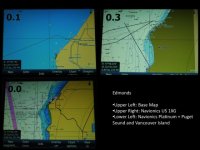
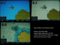
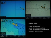
I wound up just buying the Platinum+ chart. Fisheries didn't have any to demo and I couldn't really see the difference without just buying it. I figured if I didn't like it, I was out a few bucks but I needed to know. I took a few screen shots of 3 different areas showing the difference in detail between the base map (no chips installed), the Navionics US 1XG map (came with the boat) and the Navionics 913 Platinum+ chart. I've put them into three images comparing all three levels of charts (see below).


Edmonds
Edmonds.sized.jpg

Tatoosh and Cape Flattery
TatooshAndCapeFlattery.sized.jpg

Bodelteh Islands
Bodelteh.sized.jpg
[/img]
 
rogerbum":3qc66gds said:
I wound up just buying the Platinum+ chart. Fisheries didn't have any to demo and I couldn't really see the difference without just buying it. I figured if I didn't like it, I was out a few bucks but I needed to know. I took a few screen shots of 3 different areas showing the difference in detail between the base map (no chips installed), the Navionics US 1XG map (came with the boat) and the Navionics 913 Platinum+ chart. I've put them into three images comparing all three levels of charts (see below).

Roger, are you happy with your purchase?

Warren
 
Doryman":3d0gddwv said:
rogerbum":3d0gddwv said:
I wound up just buying the Platinum+ chart. Fisheries didn't have any to demo and I couldn't really see the difference without just buying it. I figured if I didn't like it, I was out a few bucks but I needed to know. I took a few screen shots of 3 different areas showing the difference in detail between the base map (no chips installed), the Navionics US 1XG map (came with the boat) and the Navionics 913 Platinum+ chart. I've put them into three images comparing all three levels of charts (see below).

Roger, are you happy with your purchase?

Warren
Warren,

I definitely needed more bottom contours than came with the 1XG map. So I needed some other chip. The platinum + extra features such as 3D displays and aerial images of land masses and marina are really not that big of a deal although I think I might occasional use the aerial images of marinas. One thing I did notice with the new chip is that when I scroll across large distances, I don't get completely black screens during the scrolling. Lower resolution maps are pre-fetched so that scrolling is much better. So bottom line, I'm much happier with this chip than the 1XG chip but I don't know if there is an intermediate priced solution that would make me just as happy. However, I don't have time and $'s to explore every option, so I just bought the more expensive one.
 
I finally bit the bullet and purchased a Raymarine C90W chartplotter, it has not arrived as of yet, the unit has the CF chart slot and Navionics base map. I will have to see how detail these base maps are before I purchase a new chip. I see that Raymarine has a converter chip where you can slide an SD chip into the CF sleeve, not sure if this accepts the micro SD or just the standard SD only. Things change so fast just like computers, one buys a new computer and is old the next day.
 
Back
Top