The Galaxy 15 satellite which carries the WAAS GPS signal has been drifting over the last two weeks and is essentially uncontrollable. Intelsat has been unable to shut the satellite down since it has drifted out of its orbital slot and is still operating (kind of like a moving microwave tower). This is one of the satellites which carries the WAAS payload for improving the accuracy of GPS signals. From this article, http://www.spacenews.com/satellite_tele ... delay.html the prognosis doesn't look very good. While they didn't discuss the effects on GPS accuracy it looks like it won't be as good as it was.
You are using an out of date browser. It may not display this or other websites correctly.
You should upgrade or use an alternative browser.
You should upgrade or use an alternative browser.
WAAS Satellite Drifting
- Thread starter tpbrady
- Start date
Actually the control was lost a month ago. The main areas affected with be NW Alaska--most of Mainland US will still have accurate WAAS. Even without WAAS, our GPS will be very accurate--generally within 3 to 5 meters.
Although Aviation has not gone onto GPS/WAAS, there are gong to be some airports in Alaska affected by this loss of the satellite.
If you want to know what WAAS is doing right now: http://www.nstb.tc.faa.gov/index.htm
Although Aviation has not gone onto GPS/WAAS, there are gong to be some airports in Alaska affected by this loss of the satellite.
If you want to know what WAAS is doing right now: http://www.nstb.tc.faa.gov/index.htm
Bob
Sounds like in the Prince William Sound area of Alaska the WAAS will still accurate. Please correct me if that's not right.
I agree with you about the GPS signal without WAAS being very accurate. The GPS we used for the Nobletec Software on computer didn't have WAAS ability and it got us around quite well in our past trips on the Alaska Inland Passage. Was looking forward to seeing if the WAAS signal made a difference on our planned cruise of PWS this summer, so hope it is and continues to be accurate there.
Jay
I am not suggesting that the drifting WASS has anything to do with it, but this seemed like a good thread to hijack to talk about the little anomaly I saw the other day.
I finally made it out sturgeon fishing a week ago (caught a fish, too!), and I noticed that both my Garmin chartplotters forgot where north was while anchored. Or they both thought it was off about 180º. Always before when anchored or moored the GPS compass on both units have stayed right on the mark and never lost bearing even though they were not moving. I thought it odd that Washington and Oregon had swapped places and stayed like that until the boat was underway again. I even turned the units off and back on a couple times. I didn't think to check the coordinates they displayed, but I did check the sattelite status on the big unit and it had fixes on 12 of them. I also fiddled with the orientation but was still fishing backwards on the river. Strange. Once I pulled anchor and took off, all was right.
I finally made it out sturgeon fishing a week ago (caught a fish, too!), and I noticed that both my Garmin chartplotters forgot where north was while anchored. Or they both thought it was off about 180º. Always before when anchored or moored the GPS compass on both units have stayed right on the mark and never lost bearing even though they were not moving. I thought it odd that Washington and Oregon had swapped places and stayed like that until the boat was underway again. I even turned the units off and back on a couple times. I didn't think to check the coordinates they displayed, but I did check the sattelite status on the big unit and it had fixes on 12 of them. I also fiddled with the orientation but was still fishing backwards on the river. Strange. Once I pulled anchor and took off, all was right.
I am not worried too much about accuracies due to lack of WAAS. I very rarely ever acquired the signal off of the 133 satellite due to the low elevation angle. If you were in an east/west fjord, generally it was blocked. The biggest problem I run into is inaccuracies in charts versus GPS locations. I've passed through several small islands. The good news was both the Navionics chip in the Lowrance and NOAA charts in Coastal Explorer both agreed.
Tom Brady has nailed the accuracy problem--it is the charts, not the GPS. We cruised AK for 4 summers with just the old Furuno GPS30--no charts. We did fine (had been many hundreds of thousands of miles with no gps too).
As for the north--unless you have a Furuno GPS compass (SC 50 $3706)--which uses 3 differential GPS recievers, you will not get a good GPS compass reading when anchored. You have to have movement--and it takes a few seconds for the track to be established. Sometimes a slow drift will be enough--sometimes not. It may have been co-incidence, that the chart display continued to North or heads up the same...or you might have been dragging anchor??
As for the north--unless you have a Furuno GPS compass (SC 50 $3706)--which uses 3 differential GPS recievers, you will not get a good GPS compass reading when anchored. You have to have movement--and it takes a few seconds for the track to be established. Sometimes a slow drift will be enough--sometimes not. It may have been co-incidence, that the chart display continued to North or heads up the same...or you might have been dragging anchor??
In three different years and near 4000 miles cruising the Alaska Inland Passage using mainly a Lowrance Globalmap 100 handheld type gps for signal to Nobletech electronic charts on computer found it gave an extremely accurate position of our boat on the charts. Many hundreds of miles close to shore without any surprises of tidal rocks, reefs and islands or water depth along shoreline not being where they were supposed to be in relationship to us except when navigating up tidal rivers to salt water lakes quite a few miles from the ocean proper. Not saying the signal can't be lost or other problems with charts and signal happen just overall a very dependable way to navigate. With my lack of previous experience boat navigating on the ocean wouldn't have considered making these trips without the gps.
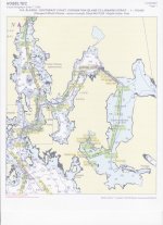
These are photos of our routes and tracks showing how gps on charts can cause trouble in these salt water lake areas or other if signal or chart was incorrect. The first photo is of the overall route and tracks into the inner lake.

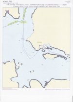
This photo shows planned route and then the gps tracks of actual route taken in narrow tidal channel to inner lake.

Our nights anchorage in the center of this photo shows us on the chart to be on land.

Jay
These are photos of our routes and tracks showing how gps on charts can cause trouble in these salt water lake areas or other if signal or chart was incorrect. The first photo is of the overall route and tracks into the inner lake.

This photo shows planned route and then the gps tracks of actual route taken in narrow tidal channel to inner lake.

Our nights anchorage in the center of this photo shows us on the chart to be on land.

Jay
Jay,
Those are similar areas to where I have passed through islands. What really bothers me with GPS and charts is when going down the Seward Highway to Whittier, when the GPS road map shows me 500 feet out in the Turnagain Arm or the same distance the other way along the railroad tracks.
Those are similar areas to where I have passed through islands. What really bothers me with GPS and charts is when going down the Seward Highway to Whittier, when the GPS road map shows me 500 feet out in the Turnagain Arm or the same distance the other way along the railroad tracks.
Tom
I too have had much more problem with gps showing me where I'm not with vehicle on roads than boat on water. Found the different garmin handhelds on land with topographical maps to again be extremely accurate in location placement.
Have had considerable problems with different gps devices locking up, computer navigation software problems even a computer ruined by saltwater and a garmin gps lost overboard, but have never lost the satellite's signal to the gps yet. Think it prudent to be prepared for losing the gps signal or it not showing your location accurately on electronic chart while on a cruise but even more important to have at least one or preferably two backups to the main gps and electronic chart on boat especially if planning or exploring remote areas where there are few if any other boats.
Jay
