Sandys counterclockwise circumnavigation Vancouver Island

smckean (Tosca)":1avhimaj said:
I will hang out in the Broughtons for a week or so, before I cross the southern part of the Queen Charlotte Strait, into Port Hardy, and then up to Balaclava Island ...

Sandy, like others I have found Port McNeill to generally be a better option for cruisers than Port Hardy. Grocery, restaurants, laundry, and hardware/chandlery are all within easy walking distance. I have docked at both the municipal Port McNeill Boat Harbour and the privately owned North Island Marina (my favorite). At the latter facility, earlier this month, I paid about $32 CAN a night for moorage (without power). North Harbour Marina lacks washrooms and showers. Public restroom is open at the Boat Harbour office during business hours; you can also pay there to use their subpar showers.

When I was at Port McNeill, week before last, the North Island Marina was full up—no room for another boat. So it might be a good idea to have someone make a reservation for you (someone you can contact with your inReach).

If you haven't been to Alert Bay, I highly recommend a stop there before heading into Port McNeill or Port Hardy. No gas, but an OK grocery, and a really wonderful museum, the U'mista Cultural Centre, which has a fine collection of historical native art. The dockmaster at Alert Bay Boat Harbour has been able to find space for me every time I've been in there. Phone him or call on Channel 66A. Very nice, 24/7 restroom/shower at the head of the dock. Code comes with your very low docking fee.
 
Plus One on Andy's recommendation for Alert Bay, but also adding, go right, down the street to the totem park, and past that to Duchesses Bannock. Way good, and really worth the walk. Tell her Hi from me. to if you are there.

Harvey
SleepyC :moon

9_Sept_Seq_2019_Cal.thumb.jpg
 
Well, I got up early (OK, earlish :-) yesterday and did the Johnstone Strait thing while the water was flat. Wonderful cruising doing 23 MPH (statue) at 4100 RPM....much like what it feels like to ski fresh powder snow. Then the fog moved in. First time on this trip running blind with the radar. It was good practice to see how the radar operates in relatively open water like that (no Harvey :wink:, I didn't stay at 4100, but dropped to my favorite hull speed spot of 1800 RPM) Soon enough I turned the corner into Havannah Channel. Dropped the hook at the first reasonable place (Burial Cove) since I had chores to do and ZERO plan for the Broughtons -- at that moment I had no idea whether to turn right or left. With some Garmin based communications with Randy Shuman and my Waggoner, I now have a general plan to go east and north before crossing back to the west ending at Sullivan Bay.

Thanks to the wonderful advice from you guys above, I've changed the plan to go to McNeill rather than Hardy. I expect to make that crossing in about a week -- weather permitting. It's about time for an oil change, so I will be trying to get that done at McNeill, and if possible, do one of those things where they pin the boat at high tide to some kind of support structure, so that at low tide the bottom is exposed for a power wash.

I have extremely weak Internet here (1 bar that comes and goes), and I expect I will lose it altogether once I shove off today. Speaking of that, first thing I will do is pull my crab trap I set as I pulled in here, I have low expectations since I see no evidence of anyone crabbing up here. I looked with binoculars at the semi-commercial docks around here for signs of old crab traps, buoys, etc, but saw none. People definitely shrimp up here. I see buoys set in 300 - 400' of water all the time, but basically never see anything that looks like a crab pot set. I was hoping to eat crab up here, and I didn't want to bring a pot puller etc for shrimp. I do expect to get some salmon on the west side. I am set up for that.

P.S. Thanks for the links for the PDFs. My connection is too poor to download them. All I seem to be able to do now is text-based stuff. I'll download the PDFs eventually.
 
Sandy, Canoe Cove just down towards Minstrel Island and a left through the channel should have good I-net and and fuel.

But you may not get this from where you are.

All the best.

Harvey
SleepyC :moon

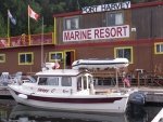
Your not far from here, but it has changed.
7_SleepyC_at_Port_Harvey_001.thumb.jpg
 
My favorite marina? Lagoon Cove on East Cracroft Island.

Well, today was a big day.....I went over the top of Vancouver Island....aka...Cape Scott. It wasn't easy. During the 8 hour trip, I spent 4 of them working the wheel and the throttle hard every second in chaotic seas and an underlying 4 foot swell (couldn't even pee). Eventually, the wind came up, but by then I was over and going downwind.

Gotta sit here in Winter Harbor, among the googles of fisherman, for a couple of days to wait out a gale that is expected tomorrow. Then around Brooks Peninsula....the crux of this entire trip. (You can get killed doing Brooks if you f*** up.)

After that, this horse is gonna start smelling the barn....I can feel it already.

P.S. Port McNeill *was* a great provision spot just as you all advised me. Main thing....every type of store is well stocked AND within easy walking (no hills) walk of the marina.
 
Sandy, I would like to see video of what it was like out there for you, but know how hard video is to get when it’s just a bit rough on the outside, let alone really rough & video seems to flatten conditions making it look much better than reality. I’ve never been able to get video during the really rough times except for Fords Terror & it ended really close to the start.

Yes, in the PNW, the Peninsulas & capes can be extra hazardous as you are aware. You’ve taken on a real challenge & I’m wishing you the best in this endeavor, as I follow your In Reach tracks. Being solo means you don’t have anyone else to think about, but also no company to help lower the sometimes fear factor. When I was on the outside solo towards the end of this years SE Alaska cruise, there were times, when I would have preferred to be elsewhere.

Jay
 
Sandy, don't hurry down the coast. Take you're time and you'll see some wonderful sights such as Nootka, where Cpn Cook landed. I know you've seen a lot of the eastern part of Vancouver Isle, but it's hard to get to the west side and please enjoy it whilst you're there.

We took Journey On to the west coast by truck/trailer, but you're dong it the right way, by boat. Those inlets have some wonderful towns at their end, be sure you visit them, such as Tahisis and Tofino. Stop by Ucluelet and explore the whole area, the Broken Islands, etc. Spend a night at the Yacht Club dock which is at the opposite side from Ucleulet (sorry, I cant remember the name) where you'll meet other west side cruisers.

Now that you're there, the best is yet to come.

Boris
 
Thanks journey on for the insight. I am already seeing the wisdom of your comments as I sit here in Winter Harbor checking PredictWind every couple of hours.

This marina is very rustic....not anything like some of the posh marinas on the east side (such as Blind Bay). There ain't no 70 foot Ocean Alexanders here....no ma'am. This place caters to hard core salmon fisherman and fisherwomen. No really big boats here, but those that are here are built strong and designed to handle rough seas. ABSOLUTELY nothing fancy (not to say there aren't some pricey boats with 600 HP on the back). I thought I would be bored here, waiting as I am, but far from it. I'm just hanging on the boat on the dock doing chores (laundry, email, etc), and it has been fascinating watching these guys/gals take off, come back (some with fish some without), clean fish (seagulls at the ready). There is a reality here on the west that ain't on the east.

One point....nothing wrong with trailering to explore these west side bays; BUT let me tell you, if, like me, you are doing it as a continuous boat trip, those bays are separated by headlands. Those headlands concentrate wind and waves....AND....there is absolutely no protection. For me, the bays are a given....no worries there, but where my mental energy goes is to those headlands. Tomorrow is still 25 to 35+ at Brooks Peninsula....ain't going. Looks like Wednesday is my day if I plan my departure right. Frankly, all I really care about on this style trip is getting safely around those headlands!!!
 
Hey Sand, I'm caught up again. Good to see you in Winter Harbor. Take you time, and enjoy the moment.

Adventure cruising equals hours of pleasant boredom punctuated by moments to hours of "What am I doing here, and Why" running circles around in your head.

Following with interest and respect.

(Oh and you were right, it was Lagoon Cove)

Harvey
SleepyC :moon

9_Sept_Seq_2019_Cal.thumb.jpg
 
From the Windy app it looks like your going to take a beating Wednesday, perhaps lessened by leaving very early. Thursday/Friday look better. Today/Wednday 5 foot swell on the stern with wind against.
 
Right on HunkyDory.

I was hoping I could sneak out today, but conditions are marginal at best. So I am waiting another day (3 day wait at this point), and plan to leave Winter Harbor tomorrow (Thurs). My plan is to not only round Brooks Peninsula, but to go all the way to Walter's Cove at the northern end of Kyuquot Sound....a run of about 60 miles. Hopefully, I will be able to plane at least some of that.

After that, the crux of the trip will be behind me IMHO. Other headlands represent typically 20 to 30 mile runs rather than the 90 miles that I did to round Cape Scott, and now 60 miles for Brooks. I will have a long run to get to Victoria, but that coast is more benign and has a couple of "bail out" harbors.

Frankly, I'll be glad when tomorrow is over.
 
Sandy, going out Lisianski strait to the open gulf of Alaska, I’ve waited up to 2 weeks with waves alternating between 14 & 24 feet, then still jumped the gun by a day & could have paid a high price. Best to do as you are & be patient.
 
Hey Sandy, Patience is a virtue, and hurrying can be threatening.
A good friend of mine used to have this saying as his tag line here.

"The most dangerous thing on a Cruising boat is a schedule."

Enjoy and be safe. Thanks for the tip on the track. Works great now.

Harvey
SleepyC :moon

9_Sept_Seq_2019_Cal.thumb.jpg
 
Made it. I have no schedule, but I was tired of waiting. None the less, I checked conditions this morning to be sure it wasn't still nasty. The wind was essentially non existent, but the seas were confused with a long period 4' swell as a backbone. I could not plane for most of the time. I gave the Brooks a wide berth.
 
Hi Sandy,

Still following on Garmin Inreach and enjoying this post. Congratulations in your planning and with safe travel around Cape Scott and past Brooks Peninsula.

Curious, are No-see-ums something that you have come across on the west side of Vancouver Island? I personally detest pesky bugs and flies. Are you experiencing any of these in your travel so far. Are they a problem? Thanks. Gary
 
Hello, Sandy!

I'm proud of you. Your track shows you made it down the coast to Catala Island. Good for you. I assume the rough part of the trip is nearly through. At least, you can make it through to Nootka by the back channels which, I assume will be easier. Now you can visit Zeballos or Tahsis, either one a treat.

Congratulations.

Boris
 
Looks like he dropped the hook in Queens Cove, a bit shy of the towns. There were a couple other boats in his area last night. He is using the InReach to drop the breadcrumbs.

Harvey
SleepyC :moon

1_Jan_From_Inside_the_Electronics.thumb.jpg
 
Back
Top