Intuition to Alaska - 2021

Hi Les,

If wind is SE, there's decent anchorage at Henry Bay, or just S of there, near the N tip of Denman I. Also tucked in to the E end of Comox hbr. Near Canpbell R, the S end if Gowlland hbr is good.
 
Les and Kel,
Curious, what is the length of the anchor chain and rode you will using in this travel? Will Canada allow you to go on shore to make a stern tie if needed? Also, Do you have a satellite phone as part of your inventory? Thanks. Gary.
 
Gary,
I'm carrying 50' of chain and 300' of 1/2" 3-strand on the primary rode. I have two back-up rodes with about 20' of chain and 200' of 3-strand or 8-plait. I have additional line for stern tie if needed, but hadn't really considered the implications of needing it in Canada, given the current restrictions. I'll ask tomorrow when we check in at Sidney.

Les
 
Sorry, Gary - I didn't answer your second question. No, we do not have a satellite phone with us. We are carrying a PLB.

I got an AT&T SIM card for a spare phone I had, since it appears AT&T's coverage in SE AK is much better than Verizon's (my current carrier). Found out yesterday (after successfully using the phone two weeks ago) that the device is no longer supported by AT&T. Ugh. I'll decide between now and Ketchikan whether to get an AT&T phone there.

Les
 
Winds are typically coming out of the NW or SE, blowing up or down the strait. Up close to Denman Island is Mud Bay or Deep Bay for protection from the SE wind, and just out on Hornby Island is Tribune Bay with a huge sandy gentle slope beach that is great for protection from a Northerly. But if that one clocks around and comes at you from the south you are in a pretty open situation. I would probably go into the channel west of Denman for a better chance at better protection, and a shorter run to opposite wind protection if needed. Comox Harbor at Courtney is also good for NE protection, long and shallow. Just be careful going around the entrance there, it gets shallow a long way out.

Once you pass Campbell River, your phone connection (Verizon) will decrease dramatically until you are about at the entrance to Port Harvey, then you get "coverage" off the Alert Bay system until you are at Port McNeill. Spotty coverage from there to Port Hardy, and from there pretty much nothing. VHF. The lighthouses will answer most of the time and Vessel Traffic has coverage out of Prince Rupert on 74 (or maybe Victoria on 71) .

Wish you all the best, It is beautiful up there, no matter the weather, so enjoy.

Harvey
SleepyC:moon

7_SleepyC_at_Port_Harvey_001.thumb.jpg
 
Saturday, June 12
Roche Harbor to Northwest Bay
Total distance: 83.4
Hours: 10.6

Left Roche Harbor at 6:30 and slow cruised across a very smooth Haro Strait to the Port Sidney Marina, where we tied up, called CBSA, and waited for the CBSA officers to arrive. While waiting, two other large cruisers pulled up for clearance. The officers were polite but business-like. Aside from the usual items to declare questions, they asked several regarding our readiness for this trip:
- How long have you owned this boat (11 years)
- Have you previously made a trip of this length (yes, 700+ mile circumnavigation of Lake Michigan)

One of the officers mentioned that they didn’t want people to indicate they were going to Alaska, only to go up to Desolation Sound for a few days and then return. They sounded as if we could get off the boat, as long as it’s for the purpose of required items, but to ensure we maintain social distancing when we do so. I don’t see where this will be needed, but getting off the boat to accomplish a stern-tie, if required, would seem to fall into this category. I had entered all of the information into the ArriveCAN app with a planned arrival this morning, but neither the phone agent nor the two who met us seemed to have this information. The officers at the dock took the receipt number if received from ArriveCAN. We were away from the dock at Sidney by 9:30.

We followed Captain’s Passage west of Prevost Island, then up the Trimcomali Channel west of Galiano Island. We realized we would not be able to hit the 11:45 slack at Dodd Narrows, so we got on plane and arrived at Porlier Pass for its noon slack. After listening to the mayhem at Dodd Narrows over channel 16, it’s probably best we weren’t there. We slowed a little for two tugs pulling logs and rock through Porlier Pass, then went through without incident.

The Strait of Georgia welcomed us gently, with winds out of the ESE and waves of no more than a foot. The waves were on the beam for the first seven miles, but after turning more westerly at Gabriola Island, the seas become following and the ride smoothed for the rest of the day. As the flood tide kicked in, we got a little boost of speed as well.

All in all it was a good day, good progress, and cooperative weather.

Les and Kel Rohlf
 
Les and Kel, Well done. Hope you are having a good night -- wherever. Yes, Dodd can be crazy. Doesn't need to be, but there are those who for one reason or another can't/won't use a radio and think we all know what they will do and can read their minds, OR, think they are entitled and we are all subordinates. You do want to give the commercial guys plenty of room and they are pretty good about letting you know their plan if you talk to them.

Same thing up at Seymour, but it is wider and longer. You can run it with some current if it is going your way, so you don't have to hit slack right on the minute. 5 - 10 should be comfortable but you will not want to be doing slow cruise through it.

Stay safe, and I'll catch up with you tomorrow night.

Harvey
SleepyC :moon

9_Sept_Seq_2019_Cal.thumb.jpg
 
Les and Kel, if you made 83 miles at speed most of the way, you probably burned a bit of fuel, I would guess a bit more than 40 gallons? Where will your next fuel stop be? You have a couple of more places on Vancouver Island, but after you turn the corner at Cape Caution, fuel will be a bit scarce - Shearwater is the only place I know for sure that be open. Are you aware of any other fuel stops before you get to Prince Ruppert?

It also seems strange that the Customs and Border Service agents were suggesting that you should say you were going to Desolation Sound rather than Alaska. Almost sounds like a trap, since that would not be "transiting."
 
Sunday, June 13, 2021
Northwest Bay to Henry Bay
Total Distance 38
Total hours: 3.5
We knew the weather today was likely to be less cooperative, with very high SE winds from a front along the west coast of Vancouver Island. It appeared our best hope was for a short window early in the morning where the wind was at least the same direction as the current. Given the forecast for today for winds potentially decreasing late in the afternoon, I planned to go only as far as Denman Island and wait to see what the afternoon revealed.
After initially leaving Northwest Bay at 5:15, the water didn’t seem worse than yesterday afternoon. We were able to stay on plane at 15-17 mph without any pounding. The seas continued to build to the point of becoming uncomfortable and requiring more attention as the boat tends to slide over or be deflected by waves, rather than cutting through. After a couple hours we made it to the more sheltered Baynes Sound on the west side of Denman. We dropped anchor at Henry Bay on the north end of Denman Island, where there’s a persistent breeze but very little chop.

As of 2:00pm, the winds and waves are still showing high at the Sentry Shoal Buoy in our direction of travel, so we’ll stay put her tonight and let the weather pass. The next two days look better for transiting the remainder of Strait of Georgia and Johnstone Strait. If I had gone further today, I was planning on making the 8:05am high slack at Seymour Narrows tomorrow. Given the distance, we’ll take our time and plan on the 2:30 slack.

We have placed an order for groceries to be delivered at Port McNeill on Tuesday, where we’ll also get gas & water. We’re planning for gas at Shearwater and Prince Rupert. We’re not permitted to stop at any of the native communities (e.g. Bella Bella and Hartley Bay).

Pat,
The run from Roche Harbor to Port McNeill will be the longest between planned gas stops (260 Statute miles). I'll stop in Campbell River if it looks tight. We've only run on plane a couple hours each day, with the rest of the time at a more fuel-efficient speed. We average about 3mpg with that approach.

Les and Kel
 
Les and Kel,

How embarrassing on my part that I missed in yesterdays write-up that you went from Roche Harbor to Northwest Bay. You are making good/smart travel with the weather that is being handed out to you both. Looks like tomorrow may be a little windy in the PM but fortunately it will be at your back.

You have good cruising range on your 25 Cruiser with a 100 gallon fuel capacity. Are you carrying extra fuel on board in 5 gallon containers if needed?
 
I'm not carrying extra fuel except the 4 gallons in separate containers for my kicker motor and Honda generator. I'll post some additional commentary on fuel in today's update.
 
Monday, June 14, 2021
Henry Bay to Port Neville
Total Distance 98
Total hours: 13.1

Left Henry Bay at 5:00am and slow cruised the entire way to Campbell River. The remainder of Strait of Georgia was very smooth, with only a slight chop near the end. While the gas gauge still showed half a tank, adequate for the next 100 or so miles to Port McNeill, we pulled into the Discovery Marina in Campbell River and added some gas. I still ascribe to the adage I learned as a young pilot – there are few things less valuable than runway behind you, altitude above you, and gas in the truck. This also allowed me to be more reckless with my fuel management later today, as I still wanted to make another 50 miles after going through Seymour Narrows.

We finished at the marina by 11:30, so had 3 hours to kill before the scheduled 2:30 low slack at Seymour Narrows. We slowly cruised toward the narrows, looked into the entry, and then made slow circles for an hour and a half in the small harbor just east of Maude Island. With the ebb running full force there were turbulence and waves in the channel along Campbell River a few miles prior to the narrows itself. At 1:30 a tug pulling an empty chip barge entered the narrows. Immediately after, the three larger cruisers who had been waiting followed. We entered at 1:50, 40 minutes early, and had a smooth ride through.

Pushed up the power and ran on plane for the latter section of Discovery Passage and most of today’s run west through Johnstone Strait. With winds still out of the southeast, Johnstone strait had only a light chop. Our bigger challenge was fighting the flood tide, which seemed as high as 4 or 5 knots at Race Passage. Lots of swirls and turbulence there – I can imagine it would be a handful with a sailboat. We had a couple strong rainstorms during the last 15 miles, which required us to slow down and ensure we could see and dodge any logs. We pulled into Port Neville and anchored in 25 feet of water about a mile in from the entrance.

The weather window for the next couple days looks favorable. We’ll stop in Port McNeill tomorrow for gas and a grocery drop, and hopefully anchor in a good place for the run around Cape Caution on Wednesday. We’ll post updates tomorrow and will likely be offline for a few days due to cell coverage.

Kel and Les Rohlf

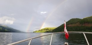
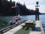
Henry Bay on Denman Island
Henry_Bay.sized.jpg

Port Neville after the storms
Port_Neville.sized.jpg
 
Nice photos. Good timing to be anchored and to fully enjoy the double rainbow. Glad things are going so well for you and that you are being blessed with following seas.
 
Les, You are doing great. Reading back, I doubt that the Customs officer was suggesting you say to go to Desolation, just did not want you to take that tack.

Prayers for a continued safe journey. There will be good anchorages up on the norths end before you take that jaunt across. Lots of spots in the islands there in the vicinity of God's Pocket.

You are well prepared and your not pressed for a schedule so take the time you need. I am guessing that there is not nearly the boating traffic that would usually be in the area so pressure on the anchorages will be considerably less.

Be safe and I will be following along.

Harvey
SleepyC :moon

ec_Scarlet_Point_lighthouse_Balaklava_Island.thumb.jpg
 
I am enjoying your trip log and I must admit that I am rather jealous. As an American you can travel through these waters, but can't go to shore or linger. As an Albertan, I am not allowed to pull my boat across the province and launch in the Pacific. We had planned to be cruising off Vancouver Island right now, but will have to wait until later in the summer when the provincial border reopens to non essential travel later in summer. Best wishes on your journey and safe travels.
 
Here's hoping to hear good news about the crossing. But, as mentioned, there may be a pause between posts due to Cell and I-net connectivity.

Harvey
SleepyC :moon

IMGP1872.thumb.jpg
 
Back
Top