You are using an out of date browser. It may not display this or other websites correctly.
You should upgrade or use an alternative browser.
You should upgrade or use an alternative browser.
12 inch GPS Plotter on a 25?
- Thread starter kaelc
- Start date
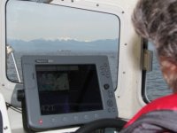
I don't think so, but then it is a personal preference. It would depend on several things: Where you place it, what your seat position is -- as in the height and forward aft positioning and the primary determining factor, What your eye level is and sight-line is.
I have a 12" in my 22 Cruiser and it works fine for me, but then I like to sit forward and high. That allows me to see over the top of the screen, easily seeing right down to the bow pulpit rail base on the stbd side.


Harvey
SleepyC :moon

I have a 12" in my 22 Cruiser and it works fine for me, but then I like to sit forward and high. That allows me to see over the top of the screen, easily seeing right down to the bow pulpit rail base on the stbd side.


Harvey
SleepyC :moon

srbaum
Member
Stir-Afloat,
One thing that I did to aid in determining maximum size, was to make a cardboard mockup of the different units that I was interested in. I taped them in place and got the boat underway. I too did not want vision restrictions, from the screen, while at 6 knots and when running at speed.
I had hoped for a big screen, but I ended up with a 7”. When I purchased the chartplotter, there was a special on the larger one, but it would have blocked a lower portion of my view...
As a side note, my boat came with a larger screen, mounter forward of my throttle. I decided to leave it there and use it for my primary radar screen.
Gene Morris
New member
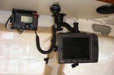
I have an older 3210 "10 inch" on Reefmadness. Would love to upgrade to a 12 when I need to replace the old one. I considered mounting the plotter on the dash but, decided to mount it over head with a great Ram mount. It is completely out of the way and I have great visibility. If you consider that mounting position you can use the larger screen without having obstructed view. There are some photos in my albums if you would like to see.
http://www.c-brats.com/modules.php?set_ ... php&page=1
Gene
http://www.c-brats.com/modules.php?set_ ... php&page=1
Gene
Micahbigsur@msn.com
New member
I am very happy with our 9" Simrad on our 25, it seems the perfect practical size.
gulfcoast john
New member

We each have our own 12" display, one on a pivoting RAM mount that Eileen can turn towards her in gnarly conditions and pivots out of the way for entering the berth. (These were discontinued 8212s at one third the original list price).
So you can have dual 12 inch displays if you want. If instead you wanted a single Garmin 24 inch display...now THAT would be a challenge!
Happy Displaying!
John
gulfcoast john
New member
Jim,
You two have a Great boat.
Agree with Gene that a RAM mount (fancy versions under $100) could multiply your mounting options and be WAY worth it in the long run.
Just consider!
Happy Mounting,
John
You two have a Great boat.
Agree with Gene that a RAM mount (fancy versions under $100) could multiply your mounting options and be WAY worth it in the long run.
Just consider!
Happy Mounting,
John
Kind of depends on the plotter. They sell them by screen size. But depending on the size of the bezel, your plotter could be a lot larger than you think. IME it seems that Humminbird tends to have fairly large bezels. Lowrance seems to have narrower ones.
If they can make laptop screens with very small (almost edge to edge) bezels, you'd think they could make chartplotters that way too.
If they can make laptop screens with very small (almost edge to edge) bezels, you'd think they could make chartplotters that way too.
Micahbigsur@msn.com
New member
My new Simrad is virtually edge to edge with 1/4" bezels. (Lowrance, B&G and Simrad all the same company but have different features for fishing, sailing and powerboats)
Gene's overhead mount on the RAM mount.

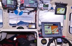
I like the overhead for some things, (you could see I have some VHF overhead and the small plotter type display in the upper right corner, is actually my primary AIS display, and I don't have to do much fiddling with it. I would think that with an actual plotter up high it might get tiring having an arm up there for adjustments, but then I'm kind of a weakling.
I would have been tempted to skip the RAM mount, and find the spot and angle that worked and mount the MFD bracket directly. Would have raised it about 3 inches to get it out of the viewing line. But that is just me.
Harvey
SleepyC :moon

journey on
New member
Hardy, why do you have 3 vhf radios? With the multiple channel monitoring, can't you monitor 3 channels? Is one a ssb radio and I didn't see it? Or do you just want them (the best answer)?
No smart-ass remark, just wondering.
Boris
No smart-ass remark, just wondering.
Boris
I had the fortunate opportunity to ride with Harvey, and being a total noob with my mind on how to set up my own future boat was thinking VHF,VHF redundancy, UHF, SSB,FRS,CB. I looked at one of Harvey’s radios that seemed unfamiliar to me and asked “what’s THAT radio?” He looked at me patiently and replied “the stereo”.journey on":k5z64e6m said:Hardy, why do you have 3 vhf radios? With the multiple channel monitoring, can't you monitor 3 channels? Is one a ssb radio and I didn't see it? Or do you just want them (the best answer)?
No smart-ass remark, just wondering.
Boris
Micahbigsur@msn.com":3nojfrer said:My new Simrad is virtually edge to edge with 1/4" bezels. (Lowrance, B&G and Simrad all the same company but have different features for fishing, sailing and powerboats)
But does the screen image go to the edge? Lots of chart plotters have large black borders on the screen that are not used for the image. The screen size is usually the image area, not the size of the "screen".
Micahbigsur@msn.com
New member
ssobol, I just turned it on, you are right, about 3/4" of the screen is black on all 4 sides, and why the 12" looks huge in proportion to the helm station. The 9" seems good to me, maybe the next generation will go edge to edge. This one has less dead space than my old Garmins.
journey on
New member
OK, this topic is about using a 12" display and all the ways it can be mounted. But it has neglected one display: the PC, which can have up to a 15" display and costs 1/4 of a 12" screen.
One can use a PC with a host of different navigation software, but only one is free and that is OpenCpn. Add a puck GPS and AIS input and you have a full featured program that will beat Naviopnics or Lowrance. Costs only $600 for the computer and a C-Dory cabin is an excellent place to use a computer, dry and even temp. A puck GPS is $50 and best of all the US charts are free. That's right, no cost for any US chart, provided from NOAA, the source of all US charting. And for those of you who cruise in Canada, for $20 you can get either the east or west coast of Canada. And that's a bargain. I don't need to point out that one can do a lot more with a PC: browse the internet, write a letter, even keep a log.
Also, one can move it to the best viewing place, on the dash or with a RAM mount in the V-berth entrance. You'll also need an inverter, a small one costs $25 if you don't already have one.
That"s $700 for a big screen display. Computer come in 10" to 15" sizes and I've even seen them up to 17".
Boris
Micahbigsur@msn.com
New member
The NMEA 2000 networks connected to chartplotters easily give a full engine readout, radar, bottom profile, stereo control, satellite weather, AIS and are resistant to salt air corrosion.
We also use 2 large GPS enabled tablets with Navionics, my PC is our 3rd backup.
No free charts of Mexico except some down here are using open CPN, which I have been unsuccessfull using, my lack of computer skills I am sure.
My current Garmin owned Navionics version is pathetic compared to the presale version of a few years ago down here in Mexico. Come to think of it it more resembles the Garmin Bluecharts lack of detail that I have had down here.
I bought the new type Simrad that has a touchscreen + manual controls, I would give it a 7 out of 10 because of the complcated menu commands and a marginal owners manual.
I still prefer Navionics to Garmin Bluecharts and C-map which I have used both of down here.
journey on
New member
I've used OpenCPN and haven't found it to be more complicated than Rose Point Coastal Explorer, for instance. In fact, I've used Fugawi, Coastel Explorer, Capn, just to name a few and they all tend to follow the same routine; learn one and move on to the next. And, since it's free, you can install it on your desk top computer and pre-plan your trips.
Here is the link to the OpenCpn Users Manual. If you use it, it'll prove a complete nav program. In fact, I'm using it right now to check the lat/long positions in "Exploring the North Coast of British Columbia".
Boris
Here is the link to the OpenCpn Users Manual. If you use it, it'll prove a complete nav program. In fact, I'm using it right now to check the lat/long positions in "Exploring the North Coast of British Columbia".
Boris
My thoughts are that any instrument in front of either the port, center or the starboard windows, that even partially obstructs the outside view, starting from the bow of the boat in any direction may be an impedance to safe navigation. What one can see is the first priority. a combination of eyesight and electronics are next followed by electronics only when necessary.
