02/05 - Snohomish River Delta Cruise

DaveS

New member
For all interested C-Brats I have scheduled our annual (unfortunately I didn't get it scheduled in Nov. 2010) Snohomish River Delta Cruise for Saturday, February 5, 2011.

We will depart the Everett, Wa. launch ramp on 10th Street at 0900 HRS. The low tide for the day will be a positive 4.4 at 1237HRS, then we will experience an incoming tide peaking at 1804 HRS with a positive 9.8 feet.

This is a one day cruise that will include an exploration of a few of the side channels of the Snohomish River as well as a jaunt up the river to the town of Snohomish. Upon our return to Everett, participants have in the past enjoyed an impromtu gathering at one of the Everett Marina Waterfront Restaurants for a no host social time of appetizers, meal or whatever folks decide.

If on the day of the cruise we are faced with any river flooding issues that could bring unwanted debris (ie: logs) down the river, then we would postpone this event until a later date.

For those that have not participated in this event in former years, you can find pictures of the previous cruises in the photo section for these events.

In an effort to fully advise participants in this cruise I offer the following paragraph as a caution advisory.....
Because we will be cruising in waters that are always changing by previous flooding situations, there is always a concern for hidden obstructions in the water, although to my knowledge no vessel has experienced a devasting mishap on this cruise.

One of the many joys of this cruise is that other than "river flooding" potential there is really nothing that will cancel this cruise. We will be protected from any wind other than what might be encountered at the launch ramp. If it rains (or snows) our C-Dorys have windshield wipers, so we are "good to go".

Added to Calendar
Signup list
-TyBoo
 
hardee":n241ip6h said:
Dave, Is any of this on a chart? and What kind of depths are you talking about?
Thanks
Harvey
SleepyC :moon


Harvey, I've not located any chart that includes this area. I've copied off pages of a road map that includes some of the various channels in the delta/slough area and color coded the routes with hi-lighter markers and distribute them to each vessel before commencement of the cruise. The area doesn't even show up on my chartplotter, however I have seen it show up on others' chartplotters. In fact at times when I explore these waters I often get the feeling that I am hearing "dueling banjos" :shock: from the nearby shores.

Being a somewhat major river with various channels the depths vary with the river flow and more so each time we experience flooding (such as is occurring as I type this right now). In some locations I've seen depths as great as 30 feet. As the channels twist and turn there are various depths encountered. In the summer time folks have been known to water ski on some of the channels. At the Eastern (Near the East end of the Highway 2 Trestle) most part of Ebey Slough we will see deep draft sailboats that have cruised up to the docks that they are now secured to. On the maps that I distribute, I mark known areas of concern and point those out to the skippers of each vessel prior to our departure.
Just like cruising out in the sound, logs and other floating debris can be a concern so keeping a vigilant lookout is imperative, (just as it is in the sound) however this is not a "high speed" cruise, but a leisurely Saturday sightseeing cruising adventure.
Several years ago a documentary about Viet Nam was filmed partially under the cover of darkness with a Viet Nam Era PBR. Since the majority of this area is a part of the Snohomish River Estuary Wetlands Preserve, special approval had to be obtained before the documentary could be filmed.
For bird watchers, this is prime spotting grounds.
 
Harvey, if you are contemplating joining in on this cruise, there is plenty of moorage with shore power available at the Everett Marina. If I were to overnight before and/or after the cruise, I would tie up on the inside of the float in front of Anthony's Home Port Restaurant. The launch ramp that we depart from is just up the river from that on the same (East side) of the river.

Will we see you there? :thup

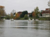
(By the way, the photo you posted above with the buildings in the back ground is a photo of the C-Dory Flotilla in the City of Snohomish).
 
Dave,

Thanks for the very detailed answer. I was really curious. It looks like a very fun, "exploring" kind of trip that I love. The photo was from the album you referred folks to early in the thread. I would love to go, and I think it is a neat photo op, but SleepyC up on blocks and fogged for yet a couple more months.

I thought about driving over and staging along the route to get some pictures. Might depend on the weather factor.

Thanks again, I know it would be fun.

Harvey
SleepyC :moon
 
Most of the waterways for the Snohomish Cruise show up as undetailed water on the charts. No contours, depths, or other info, often in the color of tideland of the brown shaded color. A good "trick" is to start a track when you go in, so you at least know how to get out and also that you once (sucessfully I hope) traveled over that area going in without incident.
 
We missed last year and planned on this one but I don't think our STBD engine will be fixed by the day of the cruise. Impeller failure and don't know what else yet.

Do it again next year please!
 
Harvey,
David is right and if you follow the link I provided you will get an idea of what the track looks like on one of the photo's.

Contrary to opinons held by some, you do not fall off the planet when you get to the end of the chart.

Other lesson learned from that trip is that if all the attendees collect together on the same dock in Everett, you had better be wearing boots.
No problem for residents of the Snoqualmie valley as they all have webbed feet by now judging from the pictures of the falls.
Also recommend that you give the duck hunters a wide berth :shock:

Merv
 
If you have a Droid or I-Phone you can track yourself on Google Earth but if you can't see the banks I would recommend staying at home. :lol:

Dave's paper map is really all you need,

M
 
In the past we've attended this get together in our 22 footer, Miss Mirth, and our 16 footer, Lizzie. It[s a great trip all around. The tour leader, Rev. Dave, gives a running educational talk over channel 68, with such facts as "Snohomish is a native American word meaning town with many antiques".
Seriously, if you haven't been there before, you will enjoy not only the fun trip, but get to see one of the finest ramp and marina facilities in the Pacific Northwest, as well as an opportunity to cruise by the Everett navy base, home to the carrier USS Abraham Lincoln. If at all possible, go to this unique CBGT. You will be glad you did.
 
I did it in '09 w/ my FIL. Fun, interesting and very low key. Dave was the lead and I just followed. 8)

I'd be interested, Dave, but I'll have to check the schedule.
 
Back
Top