| View previous topic :: View next topic |
| Author |
Message |
tom&shan
Joined: 21 Sep 2006
Posts: 316
Photos: Dakota
|
 Posted: Wed Aug 15, 2007 12:54 pm Post subject: Malibu - hits the rocks in 2000 Posted: Wed Aug 15, 2007 12:54 pm Post subject: Malibu - hits the rocks in 2000 |
 |
|
This was from another topic discussion - but my question for the C-Brats is how can something like this happen? I've spent the summer tooling around the San Juans, and as inexperienced as I am - is it just luck that I have stayed off the rocks ? The article states: "The Malibu went aground off Wasp Island in good weather and calm seas last Wednesday...the yacht was going 10 knots when it hit the rocks, ..."
Any ideas?
Tom |
|
| Back to top |
|
 |
mikeporterinmd
Joined: 15 Sep 2006
Posts: 645
State or Province: MD
C-Dory Year: 2002
C-Dory Model: 22 Cruiser
Vessel Name: Shelly IV
Photos: Shelly-IV
|
| Posted: Wed Aug 15, 2007 1:56 pm Post subject: |
|
|
If they were using an autopilot and set a waypoint that went over
the rocks, that would do it.
Mike |
|
| Back to top |
|
|
Adeline
Joined: 03 Nov 2003
Posts: 985
City/Region: Vancouver
State or Province: WA
C-Dory Year: 1989
C-Dory Model: 22 Cruiser
Vessel Name: Adeline
Photos: Adeline
|
| Posted: Wed Aug 15, 2007 3:42 pm Post subject: |
|
|
There are some areas up there that demand special diligence. Clements Reef north of Sucia and a nasty reef west of Spieden come to mind. My GPS has a neat feature  called Guardian Anti-Grounding that is SUPPOSED to prevent such mishaps. It's basically a programmable "cone" that extends forward along your course line. If anything charted interupts it an alarm sounds. Of course, it doesn't work too well with deadheads. called Guardian Anti-Grounding that is SUPPOSED to prevent such mishaps. It's basically a programmable "cone" that extends forward along your course line. If anything charted interupts it an alarm sounds. Of course, it doesn't work too well with deadheads.
_________________
Pete
Last edited by Adeline on Wed Aug 15, 2007 4:24 pm; edited 1 time in total |
|
| Back to top |
|
|
thataway
Joined: 02 Nov 2003
Posts: 20813
City/Region: Pensacola
State or Province: FL
C-Dory Year: 2007
C-Dory Model: 25 Cruiser
Vessel Name: thataway
Photos: Thataway
|
| Posted: Wed Aug 15, 2007 4:04 pm Post subject: |
|
|
At least one large boat seems to go on the rocks each year in the PNW. When we were up there, one of the 100 passanger cruise liners went on the rocks (several have since). A 90 foot yacht hit Vancouver Rock--the owner at the helm, and took most of the bottom out--a crew was hired to work 24 hours a day to rebuild the boat in Shearwater. A year or so ago one of the ferry's went on the rocks.
It boils down to not paying attention to what is being done in the wheel house! I can understand at night in the fog, but with chart plotters, and other modern devices, hard to understand!
_________________
Bob Austin
Thataway
Thataway (Ex Seaweed) 2007 25 C Dory May 2018 to Oct. 2021
Thisaway 2006 22' CDory November 2011 to May 2018
Caracal 18 140 Suzuki 2007 to present
Thataway TomCat 255 150 Suzukis June 2006 thru August 2011
C Pelican; 1992, 22 Cruiser, 2002 thru 2006
Frequent Sea; 2003 C D 25, 2007 thru 2009
KA6PKB
Home port: Pensacola FL |
|
| Back to top |
|
|
Doryman
Joined: 03 Oct 2006
Posts: 3807
City/Region: Anacortes
State or Province: WA
C-Dory Year: 2006
C-Dory Model: 255 Tomcat
Vessel Name: Lori Ann
Photos: Lori Ann
|
| Posted: Wed Aug 15, 2007 7:15 pm Post subject: |
|
|
Earlier this year a boat that had just started taking people on a sightseeing tour of Deception Pass ran around -- at Deception Pass. 
Warren
_________________
Doryman
M/V Lori Ann
TomCat 255, Hull #55, 150 Yamahas
Anacortes, WA
 |
|
| Back to top |
|
|
Hunkydory
Joined: 28 Mar 2005
Posts: 2658
City/Region: Cokeville, Wyoming
State or Province: WY
C-Dory Year: 2000
C-Dory Model: 22 Cruiser
Vessel Name: Hunkydory
Photos: Hunkydory-Jay-and-Jolee
|
| Posted: Wed Aug 15, 2007 10:17 pm Post subject: |
|
|
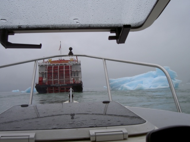
When we were up north this year was told was that the Empress of the North ran aground earlier in the year on marked rocks with a load of passengers. In 2004 we had followed it across the bar going to Laconte Glacier in the fog. Maybe depending on them wasn't such a good idea, though at the time it seemed like the right thing to do since we wanted to see the glacier and had earlier lost our electronic charting system in Fords Terror.
We ran aground on Sister Lake, Chichagof Island this year, but it wasn't exactly a normal situation. Results could have been very bad with a little more speed. Any time your boating for any reason in among the rocks in shallow water your taking a definite risk and shouldn't be there unless you and your passengers realise it and are willing to accept the possible consequences.
In normal cruising circumstances or in boats large or small that are carrying passengers for pay with today's charting systems this just shouldn't happen. Each time it does it seems someone has made what amounts to a screw up of a life time.
This a photo of the Empress of the North out of Petersburg and the one below it us following it crossing the Laconte Inlet bar.

_________________
Jay and Jolee 2000 22 CD cruiser Hunkydory
I will not waste my days in trying to prolong them------Jack London
https://share.delorme.com/JuliusByers |
|
| Back to top |
|
|
therevdr
Joined: 03 Nov 2003
Posts: 61
City/Region: Lake St. Clair
State or Province: MI
C-Dory Year: 2002
C-Dory Model: 22 Cruiser
Vessel Name: DRIFTWOOD DREI
|
| Posted: Thu Aug 16, 2007 3:22 pm Post subject: |
|
|
It isn't rocks...but it rocks the mind ~
We, to get away from it all and keep cool, often anchor on Lake St. Clair at a place called "Sand Island"; it is a site where the Middle Channel of the St. Clair River deposits its silt in Lake St. Clair (MICHIGAN).
Enough of the geography lesson....it's on the charts, it's been there "forever" / it's also on a couple of direct "as the crow flies" routes of where boats go out to and where they go back to :
An added "attraction" to our relaxation is the boat-an-hour rate of groundings and almost-groundings on the weekends and evenings. The "bonus entertainment" is the boaters screaming on the radio: "Why doesn't the Coast Guard do something about this!!?"
Fortunately for those who aren't hurled into steering wheels and windows, Sand Island is what it is described as....sand (not rock)! (There are other descriptions of the area on the charts: uncovers, marsh, "1" foot depth.)
Be safe out there!!!
therevdr on DRIFTWOOD DREI |
|
| Back to top |
|
|
|
 Search
 Private Messages
 Profile
 Log in
 Register
 Help
Help