| View previous topic :: View next topic |
| Author |
Message |
covalbro
Joined: 03 Apr 2017
Posts: 14
City/Region: Olympia
State or Province: WA
C-Dory Year: 2000
C-Dory Model: 22 Cruiser
Vessel Name: Salish-C
|
 Posted: Mon Apr 04, 2022 7:55 pm Post subject: Princess Louisa Cruise Help Posted: Mon Apr 04, 2022 7:55 pm Post subject: Princess Louisa Cruise Help |
 |
|
Hello all, Ive read every PLI cruise report I can find and Id still like some input from the experts on the positives and negatives of the different routes. I plan to leave from Olympia by water and hope to make it up to PLI as efficiently as possible. Im headed that way just before Memorial Day and have been going back and forth on which route to take. Obviously keeping weather and forecasts in mind, Im curious what you all think of going from Blaine and hugging the eastern shore of the Strait of Georgia vs heading to the Gulfs, up to Nanaimo, and crossing over. Again, I understand the choice is very much so influenced by wind direction and wave action, but does the first option promise a quicker journey to the inlet if all else is equal?
Thanks so much for the input and wisdom!
Best,
Brody
Salish-C
(22 Cruiser)
P.S. if anyone here is in South Sound area and has made the trek, Id love to pick your brain in person and grab a brew! |
|
| Back to top |
|
 |
lloyds
Joined: 02 Aug 2005
Posts: 1724
City/Region: sublimity
State or Province: OR
C-Dory Year: 1996
C-Dory Model: 22 Cruiser
Vessel Name: undecided
Photos: 1996 22 Cruiser (Lloyds)
|
| Posted: Mon Apr 04, 2022 10:04 pm Post subject: |
|
|
| The less crossing the better. |
|
| Back to top |
|
|
starcrafttom
Joined: 07 Nov 2003
Posts: 7936
City/Region: marysville
State or Province: WA
C-Dory Year: 1984
C-Dory Model: 27 Cruiser
Vessel Name: to be decided later
Photos: Susan E
|
| Posted: Mon Apr 04, 2022 10:14 pm Post subject: |
|
|
WE have made that run twice and its a flip of a coin as to what is better. I would take the west side inter island route over the east side in the open to Bellingham or Blaine route. You see its all about the weather and your timing. So the benefits of the west side Island route is that if the wind really kicks up you are in the wind shadow with a lot more choices to hide or hold over. One the east side you are stuck with a decision once you make it. The first part of the east side run from say blaine is open water for 65 to 70 miles before you get behind Lasqueti Island.
Oh shit dinner, I will post more after ..... bye
_________________
Thomas J Elliott
http://tomsfishinggear.blogspot.com/ |
|
| Back to top |
|
|
Luna C
Joined: 25 Feb 2004
Posts: 404
City/Region: Lake Goodwin/Center Island
State or Province: WA
C-Dory Year: 2019
C-Dory Model: 255 Tomcat
Vessel Name: Panthera
Photos: Luna C
|
| Posted: Mon Apr 04, 2022 10:15 pm Post subject: |
|
|
When we go north, we check in at Bedwell Harbour (if open), or Sydney and head through the gulf islands. Plenty of anchorages and a few marine parks. Nanimo is a great place to fuel up before the dash across Georgia to Half Moon Bay. Earl's Cove may Have fuel if they are open. Royal and Queen's reaches can have steady winds and steady chop. Getting into the inlet is not bad if there is no traffic (security security security) and you have an idea of the channel path. Impressive place!
_________________
Janet & Chris without CD22 Luna C
Now with Panthera 255 TC |
|
| Back to top |
|
|
JamesTXSD
Joined: 01 Mar 2005
Posts: 7484
City/Region: from island boy to desert dweller
State or Province: AZ
C-Dory Year: 2007
C-Dory Model: 25 Cruiser
Vessel Name: "Wild Blue" (sold 9/14)
Photos: Wild Blue
|
| Posted: Mon Apr 04, 2022 10:20 pm Post subject: |
|
|
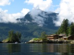
The trip to Princess Louisa Inlet is spectacular! When we went there, we were working our way to Desolation Sound and not on any schedule. That said, rather than the most efficient, consider what might be the most interesting: if you haven't been through the Gulf Islands, there are some great stops along the way. Overnight in Nanaimo, have a nice meal, then start out across the Strait of Georgia in the morning, when it is generally calmer.
I drove commercial whale watch boats in the San Juans, and even in a 55' boat, you need to keep a watch on wind and tide in the Strait. Going through the San Juans and Gulf Islands, you have protected water most of the way.
You will want to time your crossing of Malibu Rapids as you go into the Inlet. If your goal is to spend some time on the dock at Chatterbox Falls, you will likely see other boats going through Malibu Rapids and all looking for that "spot on the dock" - keep that in mind for timing, as well.
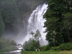
I smile when I think of that trip to Princess Louisa Inlet - you are in for a treat! Keep us posted. |
|
| Back to top |
|
|
hardee
Joined: 30 Oct 2006
Posts: 12637
City/Region: Sequim
State or Province: WA
C-Dory Year: 2005
C-Dory Model: 22 Cruiser
Vessel Name: Sleepy-C
Photos: SleepyC
|
| Posted: Mon Apr 04, 2022 11:12 pm Post subject: |
|
|
Brody, I have been to PLI and Chatterbox several times, and from several different approaches: East side up from Sunset Marina, West Vancouver, BC. Also from the West side of the water, through the Gulf Islands and both above and below Whisky Gulf Naval restriction area. I think that direction is my favorite, and once from Pacific Playground Resort which is about straight west of Lund.
Yes, the West side of the water is more protected most often. And the island route has marine parks, and lots of neat places to stop for lunch, a day or the night. Plan your crossing the Strait of Georgia for Early in the day, and go north around the WG area, (OR check VHF 16 to see if it is open) and leave early -- like before breakfast and soon after daylight, If you are leaving from Nanaimo or New Castle Island.
The East side of the water will give you much more exposure to open, big water. Also, you are crossing the outflow of the Fraser River. Give that VERY BIG Clearance, especially on a flooding tide. (That are is the only place where there has been a legitimate ship wreck of a Race to Alaska vessel and crew. A multihull disassembled itself during a mild storm, West winds, Flood tide and shallow water on the Fraser bar. It was midnight. All crew survived buy IIRC, the boat was a total loss.) And that is before you even get to Vancouver BC.
Then as you go Northerly from there, you have Strait of Georgia before you can turn and get into the channel protection. That first stretch past Vancouver is where I had my best worst ride in my C-Dory ever. I wrote some about it here:
http://www.c-brats.com/viewtopic.php?t=26513&postdays=0&postorder=asc&highlight=princess+louisa+waves+surfing&start=0
"On my first trip to Princess Louisa I got caught in Georgia Strait. We had following seas, 8 - 10 feet, quartering off the port aft. It was my fault, in buddy boating and not making the no go decision on my own. We were traveling with a couple on a 23 foot B-Boat, Deep V, with a I-O drive and they literally ran off and left us when I called and said it was too rough and I needed to slow down. That was when the waves were 4-5 feet and I didn't want to pound so hard, so I slowed to just ahead of the wave speed, mostly surfing down the fronts. It was a real test, because at least half of the waves were breaking over the tops. Real motivation to stay ahead of the curl. We survived by racing the waves, Ride the back as close to the top as we could, then go over on the round part before it started to curl and break, surf with a slight twist to port to avoid running into the shore a half mile to starboard. There were some waves that broke early, and the white water would chase us, but I had enough power to stay ahead of that. (Don't want to be in that white stuff, less buoyancy there.) I never had anything serious, but I'm very thankful my twin Yami's didn't take a powder. This situation lasted about an hour, until I could turn out of Georgia and got up into some protection in the Channel off the Strait. Didn't get pooped, but amazed at how quick the stern would raise as the following waves come up. I have been in steeper, shorter waves in Juan de Fuca, tidal washing machine stuff, and with water in the cockpit, which was all from splashing over the gunnel due to the side wind, was readily dispatched by the bilge pumps (2), a 2000 and a 1500."
Coming from the Vancouver Island side, farther north. Pacific Play Grounds is nearly up to Campbell River, and across the Georgia Strait from Lund. It is a shorter crossing, but this is getting close to where the flood tides from north and south get together, and the area has a habit of getting washing machine like. Staying farther from the islands as you make this crossing is the better path for quieter water. I launched there for access to Desolation Sound and PLI.
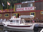
Princes Louisa is a definite great goal. It is worth the trip no matter which way you go. Be sure to Fuel at Egmont on the way up and back, and there will be a current at the dock, from one way or another, so be paying attention there. You will be able to go through Malibu Rapids a bit ahead of the slack, so time it carefully and you can lead (maybe 10 to 15 min) depending on the tide levels. If you go through the rapids first, you will be leading the pack to the dock, because inside it is all no wake area.
Enjoy and stay safe.
Sunset Marina
https://sunsetmarina.ca/
Pacific Playgrounds Oceanside Resort and Marina
https://pacificplaygrounds.ca/marina/
Harvey
SleepyC
_________________
Though in our sleep we are not conscious of our activity or surroundings, we should not, in our wakefulness, be unconscious of our sleep. |
|
| Back to top |
|
|
NORO LIM
Joined: 24 Apr 2008
Posts: 888
City/Region: Olympia
State or Province: WA
C-Dory Year: 2006
C-Dory Model: 23 Venture
Vessel Name: NORO LIM (sold 12/12/14)
Photos: NORO LIM
|
| Posted: Tue Apr 05, 2022 1:16 pm Post subject: |
|
|
You've already gotten lots of good advice and opinions. I agree with Tom. I much prefer the "western" route to Nanaimo, and then across the Straight of Georgia. I've done that many times, usually as part of a longer trip North, but also with Princess Louisa as a destination. The few times I've gone by the easterly route I've mostly regretted it. YMMV. The eastern side of the Strait leaves you exposed to relatively open water for much longer. A few hours of wind from N, S, or W can build up some nasty stuff across that fetch. I also found the passage in front of Vancouver and the mouth of the Fraser River to be more full of debris and big ships than I like. Even though it may be a little longer, the western route may be faster on a given day. The western route is more protected. But most importantly for me, I just find the path through the islands on the west side much more interesting.
One thing to consider that I have not seen mentioned yet, is the Whiskey Golf Naval Testing Range. One benefit to the eastern route is that you can pretty much ignore testing schedules if you hug the shoreline. Crossing from Nanaimo you need to find out if the range is closed and plan your route accordingly. There is an open passage way to cross even when the range is in use, and we never had any trouble following it. You just do not want to wander into the active range area when you are not supposed to be there! Here is a sample of what you can find online if you don't already know about Whiskey Golf:
"When Whiskey Golf is active, no vessels pleasure craft or commercial are allowed to enter. A safe transit corridor of 1/2 nautical mile north of Winchelsea Island and 1/2 nautical mile east of Ballenas Island is available for passage.
Additional information as to active hours may be obtained from:
Continuous Marine Broadcast (CMB) WX1 and VHF 21B (listen only)
Canadian Coast Guard Marine Communications and Traffic Services Centres (MCTS) located in Comox and Victoria (to shut down permanently in 2015)
Winchelsea Island Control VHF Channel 10 or 16"
Our normal course would be Olympia to Port Townsend, where we would spend the night. Cross Juan de Fuca early. Check in at Bedwell, and then on to Nanaimo and across - stopping as mood, mileage, daylight, and sea condition dictated.
The fact that you are planning on leaving from Olympia by water tells me speed to destination is not your sole concern. However, given the likelihood of having to slow down or wait out the weather, my experience has been that the western route is likely to be just as fast, and more interesting in the bargain.
Best of luck with your planning. You will enjoy the heck out of the trip whichever way you go!
_________________
Bill, Formerly on NORO LIM
2001 CD 16, 2001-2006
2006 CC 23, 2006-2014 |
|
| Back to top |
|
|
journey on
Joined: 03 Mar 2005
Posts: 3599
City/Region: Valley Centre
State or Province: CA
C-Dory Year: 2005
C-Dory Model: 25 Cruiser
Vessel Name: journey on
Photos: Journey On
|
| Posted: Tue Apr 05, 2022 7:22 pm Post subject: |
|
|
Here's my 2 cents. We always went up Jervis Inlet in the morn, so there was always a spot on the dock at Chatterbox Falls.
This means, of course, that you have to spend the night somewhere between Nanimo and Jervis. We would end up at Pender harbour, on the town dock. A lovely place and Agmemnom Channel is right around the corner. If you leave Namino early also, the wind isn't up for the crossing to Pender and you arrive early enough to get a spot on Pender's dock. Try the Royal Candian Legion for dinner.
We came down the east side of Strait of Georga a couple of years ago.. It was windy, from various directions and gave us a rough ride, especially from Secret Cove to Gibsons. Leaving early didn't help, so I assume a front came through.
Boris |
|
| Back to top |
|
|
Pat Anderson
Joined: 02 Nov 2003
Posts: 8556
City/Region: Birch Bay, WA
State or Province: WA
C-Dory Year: 2005
C-Dory Model: 25 Cruiser
Vessel Name: Daydream
Photos: Daydream and Crabby Lou
|
| Posted: Wed Apr 06, 2022 11:15 am Post subject: |
|
|
We live in Blaine and have done PLI a couple of times - a special place not to be missed! My vote is for crossing from Blaine to Sucia then into the Gulf Islands, and spending a night at Newcastle Island at Nanajmo.The only time we have grounded (except on the Great Loop) was on the Fraser River delta when we went up the mainland side - be sure you give it a WIDE berth if you go that way (not recommended) and that your chartplotter or iPad is zoomed WAY in tight so you can see where the dividing line between shallow and deep water is! Also be sure to fuel up in Pender Harbour so you have a full tank (or full tanks) before heading up Agamemnon Channel!
_________________
DAYDREAM - CD25 Cruiser
CRABBY LOU - CD16 Angler (sold 2020)
Pat & Patty Anderson, C-Brat #62!
http://daydreamsloop.blogspot.com

|
|
| Back to top |
|
|
NORO LIM
Joined: 24 Apr 2008
Posts: 888
City/Region: Olympia
State or Province: WA
C-Dory Year: 2006
C-Dory Model: 23 Venture
Vessel Name: NORO LIM (sold 12/12/14)
Photos: NORO LIM
|
| Posted: Wed Apr 06, 2022 1:23 pm Post subject: |
|
|
Pat makes a good point about the Fraser River delta. The is a lot of shallow (and often very muddy) water a looooong way out into the Strait.
I should mention, also, that on a couple of occasions we have crossed the Strait of Georgia south of Nanaimo. Depending on the tides and the amount of boat traffic, Dodd Narrows (the southern entrance to Nanaimo if you take the western route all the way) can be a delay and something of a hassle. If the Strait looks calm and the forecast looks good, and Whiskey Golf is not active, you can make a more diagonal crossing from one of the gaps in the western islands. Gabriola Pass is the northern-most of these gaps. It is a picturesque alternative if you don't have your heart set on stopping in Nanaimo. |
|
| Back to top |
|
|
hardee
Joined: 30 Oct 2006
Posts: 12637
City/Region: Sequim
State or Province: WA
C-Dory Year: 2005
C-Dory Model: 22 Cruiser
Vessel Name: Sleepy-C
Photos: SleepyC
|
| Posted: Thu Apr 07, 2022 10:11 pm Post subject: |
|
|
I forgot to mention Dodd Narrows. It is one of the funniest places I have been on the water. Seems like the North end is always lower than the South, so when traversing you are either going a definite up hill or down hill. And it always seems quite steep.
It is worth doing if your timing is going to be close, and you are heading into Nanaimo. It is prudent to do a Securatay call prior to entry. Going from South to North the fun starts almost at the (N) end of the pass.
Harvey
SleepyC
 |
|
| Back to top |
|
|
Pat Anderson
Joined: 02 Nov 2003
Posts: 8556
City/Region: Birch Bay, WA
State or Province: WA
C-Dory Year: 2005
C-Dory Model: 25 Cruiser
Vessel Name: Daydream
Photos: Daydream and Crabby Lou
|
| Posted: Fri Apr 08, 2022 5:51 pm Post subject: |
|
|
| hardee wrote: |
It is prudent to do a Securatay call prior to entry. Going from South to North the fun starts almost at the (N) end of the pass.
Harvey
SleepyC
|
Love your phonetic spelling of "securite,"Harvey! |
|
| Back to top |
|
|
hardee
Joined: 30 Oct 2006
Posts: 12637
City/Region: Sequim
State or Province: WA
C-Dory Year: 2005
C-Dory Model: 22 Cruiser
Vessel Name: Sleepy-C
Photos: SleepyC
|
| Posted: Sat Apr 09, 2022 2:52 am Post subject: |
|
|
| Pat Anderson wrote: | | hardee wrote: |
It is prudent to do a Securatay call prior to entry. Going from South to North the fun starts almost at the (N) end of the pass.
Harvey
SleepyC
|
Love your phonetic spelling of "securite,"Harvey! |
Thanks Pat, I should have put it in quotation marks though. Whoops.
Harvey
SleepyC
 |
|
| Back to top |
|
|
drbridge
Joined: 25 Jun 2014
Posts: 222
City/Region: Sequim
State or Province: WA
C-Dory Year: 2004
C-Dory Model: 22 Cruiser
Vessel Name: Susan Marie
Photos: Susan Marie
|
| Posted: Sun Apr 10, 2022 11:22 am Post subject: |
|
|
We went up to Louisa the summer before covid hit. We opted for the western route crossing Georgia strait from Nanaimo. Another good thing about taking this route is that you can sit and wait for the right weather window at Newcastle Island marine park. There are plenty of well protected bouys to tie up to and also dock space. The Island is fun to explore. I even rented a bike and rode around the island. There is also good cell coverage here for weather reports. The important part of crossing the Strait of Georgia is to do it when conditions are right. Allow yourself extra time in case you have to wait out the weather. Also, Eggmont is a great place to stage for heading up Jarvice strait. There was fuel available and if you leave early you will be well ahead of the boats leaving from pender.
_________________
Doug & Susan |
|
| Back to top |
|
|
covalbro
Joined: 03 Apr 2017
Posts: 14
City/Region: Olympia
State or Province: WA
C-Dory Year: 2000
C-Dory Model: 22 Cruiser
Vessel Name: Salish-C
|
| Posted: Fri May 06, 2022 10:02 am Post subject: |
|
|
Thanks for all the suggestions! This will definitely by my most involved trip to date so I'd prefer to over-plan and have plenty of contingency options.
Here's what I'm thinking so far based on our timeline and all the advice I've gotten (feel free to weigh in!).
Day 1: Trailer from Oly to Anacortes, cruise to customs at Bedwell Harbor. If there's time and favorable weather (a common thread of IFs in this trip plan) possibly push up to Nanaimo, arriving late in the evening.
Day 2: Early morning crossing of the Straits (if favorable conditions), up the Agammemnon Channel to Egmont. Hope to arrive here by 10 am or so. Re-fuel and last-minute provisions before going up the inlet. Malibu should be slack at 6:30pm which allows plenty of time to motor up the inlet. My hesitation here is that this means getting to PLI in the evening, on a Saturday, over Memorial Day Weekend. If there aren't any spots on the dock, maybe ask around about rafting up, otherwise spend the night on the hook in front of the falls and catch a dock spot the next day. I realize this is a pretty big day with lots of IFs. Having a plan B for if the crossing doesn't go according to plan will be a given.
Day 3-6 enjoy the inlet!
Day 7-11 slowly reverse course and take time to explore some new spots en-route back to the launch.
Thoughts?
Many thanks, friends!
-Brody |
|
| Back to top |
|
|
|
|
You cannot post new topics in this forum
You cannot reply to topics in this forum
You cannot edit your posts in this forum
You cannot delete your posts in this forum
You cannot vote in polls in this forum
You cannot attach files in this forum
You cannot download files in this forum
|
|
 Search
 Private Messages
 Profile
 Log in
 Register
 Help
Help
