| View previous topic :: View next topic |
| Author |
Message |
colbysmith
Joined: 02 Oct 2011
Posts: 4545
City/Region: Madison
State or Province: WI
C-Dory Year: 2009
C-Dory Model: 25 Cruiser
Vessel Name: C-Traveler
Photos: C-Traveler and Midnight-Flyer
|
 Posted: Sun Dec 20, 2020 2:40 pm Post subject: AIS transmissions Posted: Sun Dec 20, 2020 2:40 pm Post subject: AIS transmissions |
 |
|
Moved from another thread on a different topic...
Me: | Quote: | | Speaking of AIS. Not the inspections but the electronics. For whatever reason(s), AIS transmitters will not work on Lake Powell. And I don't believe Yellowstone either... |
Bob: | Quote: | | Colby, why do you say AIS will not work? I have seen a couple of AIS signals there. There is no technical reason that AIS should not work at either Powell or Yellowstone. (There are going to be the signal limitations by line of site, because of canyons. |
Hi Bob, Harvey asked me privately about the AIS stuff as well. Here was my reply to him:
I used Wild Bill on Mystery Girl as my checker. lol. He could not see my AIS while we were at Lake Powell. I don't think he saw it at Yellowstone either. Not sure if you remember way back when, when I first got an AIS transmitter. It was a Chinese unit. I installed it as a stand alone unit, and because of how it was set up, I could see myself via my VHF radio with a receiver. It was several years ago when I was at Lake Powell that I thought the unit was acting up as I was not able to see myself. Also, couldn't find any tracks on any of the websites. After that I decided to get rid of that unit and buy a nice new American unit. (I gave the old Chinese unit to a friend that was going to give it to a buddy that he runs with.) I do remember right before I pulled it out, it was working again here in the Midwest....
Well lo and behold when I went back to Lake Powell with my new unit, still no apparent transmit. The new unit gives me a red light when it's not transmitting properly. Hooking it up to my computer (New one allows PC diagnostics), it showed it was receiving all satellites, but was not sending out position. Somewhere I read that the government can control the transmission of AIS. In fact, I think when areas of heavy class A traffic, the class B units can be silenced by the controlling authority. I think.... So, I wonder if the units are remotely shut down in this area, or if there is something that goes on with the surrounding canyons and mountains. It's only been at Yellowstone and Lake Powell as for places I've been, that I've noticed my AIS not transmitting. Nor do I receive any signals. (I don't know of any in these areas anyway...) I've spent a few hours googling for answers, but have found none. Maybe some time I'll send an email to the manufacturer or to the USCG and ask.
Harvey sent me another PM with some thoughts. Harvey, if you don't mind I think I'll just move the conversation here so we can maybe get more thoughts on this. Bob, in the few times I've been to Lake Powell with an AIS, I've yet to see any other AIS boats in that area. I know that the ground stations that will put tracking on the web is many times using satellite signals. IE, my boat was not tracked on much of the Cumberland River. However, the commercial traffic was showing up. But if you looked closely at those tracks, they were done with satellite vs. ground stations. Anyway, I have no idea why by AIS transmitters would not transmit on Lake Powell. I only know that mine weren't, but that at least my newest unit does work properly, and works fine in other locations I've traveled. Colby |
|
| Back to top |
|
 |
colbysmith
Joined: 02 Oct 2011
Posts: 4545
City/Region: Madison
State or Province: WI
C-Dory Year: 2009
C-Dory Model: 25 Cruiser
Vessel Name: C-Traveler
Photos: C-Traveler and Midnight-Flyer
|
| Posted: Sun Dec 20, 2020 2:46 pm Post subject: |
|
|
Some more information I found, that I'm still digesting....
Class A And Class B Automatic Identification System (AIS)
Posted on by Ocean Time Marine
AIS information is divided into two classes classes A and B depending on the AIS transponder transmitting the AIS information. These classes are of great importance to the capabilities of your AIS. There is a great difference between the two classes, both in terms of extent, complexity and price.
AIS information from a class A transponder will always be prioritised and, thus, be shown to other ships in the area, whereas AIS information from a class B transponder will not be shown until or if there is room on the AIS channel. AIS of class A In order to avoid that the ships AIS systems all speak at the same time, large ships use an AIS system of class A, which is called SOTDMA (Self-Organized TDMA).
An algorithm ensures that the AIS transmitter of a ship first notices how other ships transmit their messages and, subsequently, adjusts its own transmission pattern to that of the others. In case there are more ships fitted with AIS of class A in an area than the capacity of the bandwidth, the system will automatically limit the area of coverage so that the remotest ships in the area are discarded. AIS of class B Small vessels fitted with AIS, such as recreational craft, can use a less expensive AIS station of class B, which transmits less frequently. This system is called CSTDMA (Carrier Sense TDMA). A class B station will listen for a couple of milliseconds to hear whether a large ship is transmitting before it transmits its own message.
Some rather old AIS stations of class A can see only the position, but not the identity of these class B stations and large ships can choose not to show AIS stations of class B on their displays if their displays become confused because of too many yachtsmen. Thus, the class B information will be shown to other ships in the area only if or when there is room on the AIS channel. On an AIS transponder of class B you can see whether the information transmitted is prioritised and thus displayed on other ships. |
|
| Back to top |
|
|
hardee
Joined: 30 Oct 2006
Posts: 12632
City/Region: Sequim
State or Province: WA
C-Dory Year: 2005
C-Dory Model: 22 Cruiser
Vessel Name: Sleepy-C
Photos: SleepyC
|
| Posted: Sun Dec 20, 2020 6:04 pm Post subject: |
|
|
Colbly, I think it is important to note that this prioritizing and display is only going on on the vessels AIS display or chart plotter display... not by some "Traffic Control Center" or satellite system. I believe my Watchmate will do that by limiting the number of AIS contacts to a user selectable number up to about 20. Also, when the signals are dense, the farther ones away will drop off the list until they become closer. It is also able to filter approaching compared to non moving or departing vessels from my location or course.
| Quote: | "AIS information from a class A transponder will always be prioritized and, thus, be shown to other ships in the area, whereas AIS information from a class B transponder will not be shown until or if there is room on the AIS channel. AIS of class A In order to avoid that the ships AIS systems all speak at the same time, large ships use an AIS system of class A, which is called SOTDMA (Self-Organized TDMA).
An algorithm ensures that the AIS transmitter of a ship first notices how other ships transmit their messages and, subsequently, adjusts its own transmission pattern to that of the others. In case there are more ships fitted with AIS of class A in an area than the capacity of the bandwidth, the system will automatically limit the area of coverage so that the remotest ships in the area are discarded. AIS of class B Small vessels fitted with AIS, such as recreational craft, can use a less expensive AIS station of class B, which transmits less frequently. This system is called CSTDMA (Carrier Sense TDMA). A class B station will listen for a couple of milliseconds to hear whether a large ship is transmitting before it transmits its own message." |
Because the AIS transponder signals are set at certain timed intervals, that "listening" waits for a clear air to output its Position, Speed, and direction information string. The Class A services are variable 5-15 second intervals, depending primarily on vessel speed. The listen period avoids "stepping on" another vessels transmission. The Class B have a less frequent transmission rate, but also listen.
From Wiki:
| Quote: | "Default transmit rate is normally every thirty seconds, but this can be varied according to vessel speed *or instructions from base stations*. The Class B "CS" standard requires integrated GPS and certain LED indicators. Class B "CS" equipment receives all types of AIS messages.
The newer SOTDMA Class B "SO" system,[23] sometimes referred to as Class B/SO or Class B+,[24][25] leverages the same time slot finding algorithm as Class A, and has the same transmission priority as Class A transmitters, helping to guarantee that it will always be able to transmit. The Class B "SO" technology will also change its rate of transmission depending on the speed the vessel is going, up to every five seconds over 23 knots, instead of the constant rate of every thirty seconds in Class B "CS".[26] Finally Class B "SO" will also broadcast at a power of 5 W instead of the previous 2 W of Class B "CS" |
* I am still trying to figure how a land based base station can shut down AIS transmissions from a remote vessel without it's consent or participation.
If I was looking at updating or acquiring a new AIS system I would be very interested in the newer SOTDMA Class B "SO" system, sometimes referred to as Class B/SO or Class B+, for it's higher watt output and emulation of the Class A characteristics, (frequency of output).
I use my AIS every time the boat is moving, like the radar, and It is, Beside my eyes and ears, my primary collision avoidance tool. Easier and quicker than radar, and very exacting.

_________________
Though in our sleep we are not conscious of our activity or surroundings, we should not, in our wakefulness, be unconscious of our sleep. |
|
| Back to top |
|
|
colbysmith
Joined: 02 Oct 2011
Posts: 4545
City/Region: Madison
State or Province: WI
C-Dory Year: 2009
C-Dory Model: 25 Cruiser
Vessel Name: C-Traveler
Photos: C-Traveler and Midnight-Flyer
|
| Posted: Sun Dec 20, 2020 6:13 pm Post subject: |
|
|
| Like you Harvey, I also have my AIS on and transmitting whenever I'm moving, or stopped for just a short period. I'll leave it on for a bit when I stop and anchor or dock at night, but then turn it back on a bit before I'm ready to head out. (As opposed to many of the yachts that leave theirs on all the time, even while docked at the marinas...) It is a little disconcerting to know that the larger class A ships can restrict class B targets. After all that's one of the reasons I have my AIS is for all others to see me. I did just send off an email to SiTex to see what they have to say about my transceiver showing an error light at Lake Powell. Will be interesting to get their answer. Colby |
|
| Back to top |
|
|
hardee
Joined: 30 Oct 2006
Posts: 12632
City/Region: Sequim
State or Province: WA
C-Dory Year: 2005
C-Dory Model: 22 Cruiser
Vessel Name: Sleepy-C
Photos: SleepyC
|
| Posted: Sun Dec 20, 2020 7:21 pm Post subject: |
|
|
Colby,
| Quote: | | "...that the larger class A ships can restrict class B targets." |
I think what they are constricting is limiting on their receiver screen, if that happens. I know that many times when I am crossing Juan de Fuca, I have contacted the commercial ships, because I am crossing the traffic lane, and verify that they see me on AIS, visually and verify intentions and and crossing (ahead of or behind -- and distance). I have never not been visible on AIS to them, and I have had them, on occasion, contact me via AIS info.
I would be interested in hearing if anyone has had issues with not being seen on AIS by commercial traffic.
Harvey
SleepyC 
 |
|
| Back to top |
|
|
hardee
Joined: 30 Oct 2006
Posts: 12632
City/Region: Sequim
State or Province: WA
C-Dory Year: 2005
C-Dory Model: 22 Cruiser
Vessel Name: Sleepy-C
Photos: SleepyC
|
| Posted: Sun Dec 20, 2020 7:55 pm Post subject: |
|
|
Again From AIS on Wiki: This is for Class A units, to help understand the "drop out" factor.
| Quote: | "In order to make the most efficient use of the bandwidth available, vessels that are anchored or moving slowly transmit less frequently than those that are moving faster or are maneuvering. The update rate ranges from 3 minutes for anchored or moored vessels, to 2 seconds for fast moving or maneuvering vessels, the latter being similar to that of conventional marine radar.
Each AIS station determines its own transmission schedule (slot), based upon data link traffic history and an awareness of probable future actions by other stations. A position report from one station fits into one of 2,250 time slots established every 60 seconds on each frequency. AIS stations continuously synchronize themselves to each other, to avoid overlap of slot transmissions. Slot selection by an AIS station is randomized within a defined interval and tagged with a random timeout of between 4 and 8 minutes. When a station changes its slot assignment, it announces both the new location and the timeout for that location. In this way new stations, including those stations which suddenly come within radio range close to other vessels, will always be received by those vessels.
The required ship reporting capacity according to the IMO performance standard is a minimum of 2,000 time slots per minute, though the system provides 4,500 time slots per minute. The SOTDMA broadcast mode allows the system to be overloaded by 400 to 500% through sharing of slots, and still provides nearly 100% throughput for ships closer than 8 to 10 nmi to each other in a ship to ship mode. In the event of system overload, only targets further away will be subject to drop-out, in order to give preference to nearer targets, which are of greater concern to ship operators. In practice, the capacity of the system is nearly unlimited, allowing for a great number of ships to be accommodated at the same time."
"Detailed description: Class B units
Class B transceivers are smaller, simpler and lower cost than Class A transceivers. Each consists of one VHF transmitter, two VHF Carrier Sense Time Division Multiple Access (CSTDMA) receivers, both alternating as the VHF Digital Selective Calling (DSC) receiver, and a GPS active antenna. Although the data output format supports heading information, in general units are not interfaced to a compass, so this data is seldom transmitted. Output is the standard AIS data stream at 38.400 kbit/s, as RS232 and/or NMEA formats. To prevent overloading of the available bandwidth, transmission power is restricted to 2 W, giving a range of about 510 mi.
Four messages are defined for class B units:
Message 14
Safety Related Message: This message is transmitted on request for the user some transceivers have a button that enables it to be sent, or it can be sent through the software interface. It sends a pre-defined safety message.
Message 18
Standard Class B CS Position Report: This message is sent every 3 minutes where speed over ground (SOG) is less than 2 knots, or every 30 seconds for greater speeds. MMSI, time, SOG, COG, longitude, latitude, true heading
Message 19
Extended Class B Equipment Position Report: This message was designed for the SOTDMA protocol, and is too long to be transmitted as CSTDMA. However a coast station can poll the transceiver for this message to be sent. MMSI, time, SOG, COG, longitude, latitude, true heading, ship type, dimensions.
Message 24
Class B CS Static Data Report: This message is sent every 6 minutes, the same time interval as for Class A transponders. Because of its length, this message is divided into two parts, sent within one minute of each other. This message was defined after the original AIS specifications, so some Class A units may need a firmware upgrade to be able to decode this message. MMSI, boat name, ship type, call sign, dimensions, and equipment vendor id. |
For the quoted info context go here:
https://en.wikipedia.org/wiki/Automatic_identification_system
Harvey
SleepyC
 |
|
| Back to top |
|
|
thataway
Joined: 02 Nov 2003
Posts: 20803
City/Region: Pensacola
State or Province: FL
C-Dory Year: 2007
C-Dory Model: 25 Cruiser
Vessel Name: thataway
Photos: Thataway
|
| Posted: Sun Dec 20, 2020 8:45 pm Post subject: |
|
|
Colby, I have seen AIS signal from the tour boat at Powell. There is no way that any entity would or. could block AIS signals at either Yellowstone or Powell.
Could someone theoretically block AIS?--only by transmitting a very strong signal on the frequencies: 161.975 MHz and 162.025 MHz, using a bandwidth of 25 kHz. Although only one radio channel is necessary, each station transmits and receives over two radio channels to avoid interference problems, and to allow channels to be shifted among ships without loss of communication.
GPS can be limited in canyons, but there are several repeaters on Navajo Mountain: VHF Channel 16, National Park service frequencies in VHF range: 171.62500Mhz, The Verizon cell signals, and ham repeaters(146.96000/146.36000; 449.92500 / 444.92500Mhz
US military has been know to blank out GPS for some time, both in the proximity of the bases and of certain ships.
Is it possible to jam AIS--yes, very easy. But for what purpose of reason?--and even if jammed your transmitter should still be transmitting.
It might be possible that there was not an accurate enough position at Powell due to shadowing in canyons, but in Yellowstone that should not happen.
AIS B is picked up by satellites...but the position reports often are outdated. Many larger recreational yachts use AIS A. Nothing in the rules that they are not allowed to use A. The time interval for AIS transmission is .26 milli seconds. This allows 4500 separate vessels to operate in the 40 mile "Range" of AIS without 'interference".
Class A transponders use a system called Self Organised Time Division Multiple Access (SOTDMA), which enables them to negotiate with other Class A transponders to reserve a time slot and book future ones. Class A transmits every 2 seconds. Class B transponders use a different technology called Carrier Sense Time Division Multiple Access (CSTDMA). Class B find points in-between the Class A to transmit every 30 seconds (ideally). Class B is 2 watts, Class A is 12.5 watts output.
To confuse things even more there is now a Class B+ which uses the same SOTDMA program as Class A and transmits at 5 watts every 5 seconds. To be clear the large ships cannot filter out the "transmission of the B" AIS, but he can filter them on his display.
Now Colby and Harey, you need to go out and get the B+ ACR has them for $ 799 , Sitex at $709. Garmin AIS 800 black box at $799. None have a display, but are NMEA 2000 integrated.
_________________
Bob Austin
Thataway
Thataway (Ex Seaweed) 2007 25 C Dory May 2018 to Oct. 2021
Thisaway 2006 22' CDory November 2011 to May 2018
Caracal 18 140 Suzuki 2007 to present
Thataway TomCat 255 150 Suzukis June 2006 thru August 2011
C Pelican; 1992, 22 Cruiser, 2002 thru 2006
Frequent Sea; 2003 C D 25, 2007 thru 2009
KA6PKB
Home port: Pensacola FL |
|
| Back to top |
|
|
gulfcoast john
Joined: 14 Dec 2012
Posts: 989
City/Region: PENSACOLA
State or Province: FL
C-Dory Year: 2010
C-Dory Model: 255 Tomcat
Vessel Name: Cat O' Mine
Photos: CAT O' MINE
|
| Posted: Sun Dec 20, 2020 9:05 pm Post subject: |
|
|
Colby, Harvey, Bob,
Great post, thanks! We have intuitively noticed that when we are navigating really heavy marine traffic areas (esp those with vessel traffic zones like the St Lawrence Seaway, Charleston, SC, Baltimore and Brunswick harbors and Key West Channel type areas) that BIG moving and non-moving targets (like 3 cruise liners tied up by Mallory Square) NEVER go dim or disappear as an AIS target, but other moored and docked boats do appear and disappear in a crowded field. Your research explains why.
Colby, when I had your exact same AIS system symptoms it turned out to be an intermittently bad VHF (shared) antenna that was very hard to diagnose (took over a year) even with a laptop and Garmin diagnostics CD connected to N2K system and Garmin AIS 600 error codes.
Are you sharing the VHF and AIS antenna, or do you have separate antennae for each? B is more desirable if you have the roof space. A 3 ft SS antenna for dedicated AIS use is fine if you dont much care about AIS traffic that is more than three miles away (I like Digital brand). Harvey, however, has to deal with REALLY fast ferries that dont ply Southern waters and he may reasonably desire a taller sensor.
While on the subject of how much electronic info is shared constantly and digitally on AIS all on VHF channel 70, we should also applaud the system that simultaneously, all the DSC contacts are also being handled on that one channel all at the same time as AIS signals! If you have heard some laconic deckhand tying up channel 68 or 71 for half an hour complaining about how his parasail customer didnt give him an adequate tip for his taking their photo....geeez!
If VHF channel 70 gets too busy with all digital info while carrying 1,000 times as much data as ANY other VHF channel, then maybe its time to give up some more radio...say, the marine telephone operator channels of VHF 24-38 and 84-88! When was the last time you hailed marine telephone operator on VHF 16 to make a marine telephone call rather than using your cell phone? 1980 or 1981 for me. When for you?
I dont want to give up my Air Supply 8 track player tapes, but we think Lew has an 8 track on Cats Claw, maybe we can play it at Hontoon.
Cheers!
John
_________________
John and Eileen Highsmith
2010 Tom Cat 255, Cat O' Mine
Yamaha F150, LXF150 |
|
| Back to top |
|
|
colbysmith
Joined: 02 Oct 2011
Posts: 4545
City/Region: Madison
State or Province: WI
C-Dory Year: 2009
C-Dory Model: 25 Cruiser
Vessel Name: C-Traveler
Photos: C-Traveler and Midnight-Flyer
|
| Posted: Sun Dec 20, 2020 9:39 pm Post subject: |
|
|
| Quote: | | It might be possible that there was not an accurate enough position at Powell due to shadowing in canyons, but in Yellowstone that should not happen. |
Bob, I keep coming back to this, even before you mentioned it. It was the only thing I could really come up with and understand in my own mind. (That and the military blockage.) And to be honest, I'm not even sure I had my AIs on in Yellowstone. Or when I did if I was even checking to see if it was working. The tour boats were not running when I was at Powell this summer. At least not in my vicinity. But the ferry was, and I wasn't receiving any AIS returns from it, assuming it even had AIS.
John, you may be on to something also. Yes, I split my VHF antenna between the AIS and one of my VHF radios. But, if this were an issue, I would think it would be an issue everywhere. In this case, the issue was only in Lake Powell, and with two different AIS systems. Whatever the issue, I did have an error light on the AIS transciever, even though my computer diagnostics of it showed good satellite coverage. Bob, is it possible to have good satellite coverage, and still not have a good position due to the canyon walls and surrounding mountains?
As I said earlier, it'll be interesting to see what SiTex replies. Colby |
|
| Back to top |
|
|
hardee
Joined: 30 Oct 2006
Posts: 12632
City/Region: Sequim
State or Province: WA
C-Dory Year: 2005
C-Dory Model: 22 Cruiser
Vessel Name: Sleepy-C
Photos: SleepyC
|
| Posted: Sun Dec 20, 2020 10:28 pm Post subject: |
|
|
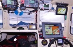
I do share one antenna, a Shakespeare short whip, with both a VHF Standard Horizon GX2150, and with the Vision WatchMate AIS through a Vesper SP160
Antenna Splitter. It is an amplified splitter with a 3 db gain.
I did have some trouble initially with the WatchMate, but after sending it back to Rodger's and having them redo the updates, it has performed perfectly. I like having the stand alone display for that one as it makes the ranges and filters very easy access, plus it does give a rough shoreline outline.
The WatchMate Vision is in the upper right corner.

Harvey
SleepyC
|
|
| Back to top |
|
|
colbysmith
Joined: 02 Oct 2011
Posts: 4545
City/Region: Madison
State or Province: WI
C-Dory Year: 2009
C-Dory Model: 25 Cruiser
Vessel Name: C-Traveler
Photos: C-Traveler and Midnight-Flyer
|
| Posted: Sun Dec 20, 2020 11:47 pm Post subject: |
|
|
| Both my antennas, including the shared one, are 8' Shakespeare higher quality. The splitter gives the AIS priority, until the VHF it shares with transmits. I believe the splitter also amplifies. Colby |
|
| Back to top |
|
|
colbysmith
Joined: 02 Oct 2011
Posts: 4545
City/Region: Madison
State or Province: WI
C-Dory Year: 2009
C-Dory Model: 25 Cruiser
Vessel Name: C-Traveler
Photos: C-Traveler and Midnight-Flyer
|
| Posted: Mon Dec 21, 2020 11:13 am Post subject: |
|
|
Well that was fast! Answer from my AIS manufacturer!
On Dec 21, 2020, at 8:59 AM, Chuck Finch <service@si-tex.com> wrote:
Hi Colby,
I believe the issue you are reporting is due to altitude. Lake Powell is at 3625 and Yellowstone is over 7000 feet. Many GPS units for the marine market are altitude limited as it is expected to be more of a coastal sea level use case. While GPS can be made to be used at altitude ( they use it in planes that fly at 35000 feet!) it is often limited in marine applications to save some cost when designing the product. This usually is verified when a unit will not have a valid position fix even though it sees plenty of satellites and altitude is over 1500-2000 feet. Sorry for the inconvenience.
Best Regards,
Chuck Finch
Service Manager
Si-Tex / Koden
(631) 996-2690 Office
(631) 996-2693 Fax
(631) 276-9068 Mobile
Web: www.si-tex.com
Emial: service@si-tex.com
Chat: (Google Talk): sitexhelp@gmail.com
And then another:
Hi Colby,
I confirmed with the engineers that there is an altitude limit. However, there is a way using ProAIS2 that you can send a command to the unit to changes the limit so it will work at Lake Powell or Yellowstone. Here is what the engineer wrote me:
Yes there is - 500m / 1640 ft above sea level. That is the default altitude for the internal GPS module, and it also applies to the MDA-5. If you want to configure it so that it will work in those locations, sending the following command will allow it to operate at altitudes up to 5000m:
$PSMT,0,3,0x2C75B2FA,1,nvseti "gpsdyn"^2C4^2C3^2C0^2C1,0*76
If you use ProAIS2 to connect to your AIS and then in the Terminal tab send the sentence above to the AIS unit it should work fine in the future,
Best Regards,
Chuck Finch
Service Manager
Si-Tex / Koden
(631) 996-2690 Office
(631) 996-2693 Fax
(631) 276-9068 Mobile
Web: www.si-tex.com
Emial: service@si-tex.com
Chat: (Google Talk): sitexhelp@gmail.com |
|
| Back to top |
|
|
thataway
Joined: 02 Nov 2003
Posts: 20803
City/Region: Pensacola
State or Province: FL
C-Dory Year: 2007
C-Dory Model: 25 Cruiser
Vessel Name: thataway
Photos: Thataway
|
| Posted: Mon Dec 21, 2020 12:42 pm Post subject: |
|
|
John, The AIS A can be switched so it transmits less frequently when stationary.
I really advocate separate antennas for AIS and VHF, despite the amp (only for incoming signals) and connivance. The AIS antenna should be tuned for the higher frequencies of AIS. (Close to weather channels)
John AIS is NOT on channel 70 (156.525 simplex). That is DSC, no AIS. AIS frequencies as I gave above and are duplex frequencies. There is plenty of bandwidth available to expand AIS (currently channels 1 and 2) to 4 or more channels if this becomes necessary in the future.
Colby, Interesting that Sitex should program the AIS transceiver to only work up to 500'. AIS is used on many lakes world wide which are over 500' high. Also every marine and vehicular GPS I have used, works fine at higher elevations...
Generally GPS receivers can get a reasonable "fix" with 3 good satellites if they are spread out adequately. So you may get GPS signals in a canyon or fjord and yet not get a good fix. We found that in Fords Terror in AK. We ignored the GPS when in steep canyons on Powell. But it would be lost even with still a couple of good satellites showing in the "constellation" view.
Since that is a limit of the Sitex you have, it would probably be a limit in the AIS B+ also. I wonder if other AIS systems also limit the altitude? GPS allows calculation of altitude. I have one which is fairly accurate. Of course in aircraft, you need that to be very accurate. |
|
| Back to top |
|
|
hardee
Joined: 30 Oct 2006
Posts: 12632
City/Region: Sequim
State or Province: WA
C-Dory Year: 2005
C-Dory Model: 22 Cruiser
Vessel Name: Sleepy-C
Photos: SleepyC
|
| Posted: Mon Dec 21, 2020 2:02 pm Post subject: |
|
|
| Quote: | | "I wonder if other AIS systems also limit the altitude?" |
I will be checking on mine ASAP. That seems bazar, but anything to save a dime.
Thanks Colby for tracking that down. I am so relived, I was thinking there was some spillover from Area 51  
Harvey
SleepyC
 |
|
| Back to top |
|
|
colbysmith
Joined: 02 Oct 2011
Posts: 4545
City/Region: Madison
State or Province: WI
C-Dory Year: 2009
C-Dory Model: 25 Cruiser
Vessel Name: C-Traveler
Photos: C-Traveler and Midnight-Flyer
|
| Posted: Mon Dec 21, 2020 2:21 pm Post subject: |
|
|
| Quote: | Colby, Interesting that Sitex should program the AIS transceiver to only work up to 500'. AIS is used on many lakes world wide which are over 500' high. Also every marine and vehicular GPS I have used, works fine at higher elevations...
Generally GPS receivers can get a reasonable "fix" with 3 good satellites if they are spread out adequately. So you may get GPS signals in a canyon or fjord and yet not get a good fix. We found that in Fords Terror in AK. We ignored the GPS when in steep canyons on Powell. But it would be lost even with still a couple of good satellites showing in the "constellation" view.
Since that is a limit of the Sitex you have, it would probably be a limit in the AIS B+ also. I wonder if other AIS systems also limit the altitude? GPS allows calculation of altitude. I have one which is fairly accurate. Of course in aircraft, you need that to be very accurate. |
I've never had a problem with my chartplotters accuracy at the higher elevations. Well except for at Lake Powell when I went far back into some of the steeper and narrow canyons. Then I almost always got an expected mapshift! Although after receiving that reply from SiTex, I was thinking about maybe contacting Garmin to see if they have any elevation limits with their chart plotters. As for my car's Nuvi GPS units, they've always seemed to work fine even crossing passes at 11,000 feet. And before I retired, we were already using GPS based systems to shoot approaches into airports, including some pretty high elevation airports.
Anyway, once I get my boat back from the shop modifying my full cover, I'll be hooking the laptop up to my AIS and shooting it the code above. 
| Quote: | | I was thinking there was some spillover from Area 51 |
Who said there still isn't?  Colby Colby |
|
| Back to top |
|
|
|
|
You cannot post new topics in this forum
You cannot reply to topics in this forum
You cannot edit your posts in this forum
You cannot delete your posts in this forum
You cannot vote in polls in this forum
You cannot attach files in this forum
You cannot download files in this forum
|
|
 Search
 Private Messages
 Profile
 Log in
 Register
 Help
Help
