| View previous topic :: View next topic |
| Author |
Message |
Wandering Sagebrush
Joined: 21 Jan 2005
Posts: 2770
City/Region: Northeast Oregon
State or Province: OR
C-Dory Year: 2005
C-Dory Model: 22 Cruiser
Vessel Name: Constant Craving
Photos: Constant Craving
|
 Posted: Sat Aug 27, 2016 12:01 pm Post subject: RFI - Hite Posted: Sat Aug 27, 2016 12:01 pm Post subject: RFI - Hite |
 |
|
I am thinking about a kayak trip to the upper end of Lake Powell next year, possibly launching at Hite. I'd like to avoid the craziness of the area around and just above Bullfrog/Hall's Crossing.
Has anyone driven in there in the past couple of years? Is there safe parking for a truck and camper? Looking at Google Earth, I see a track from the ramp down to the water, perhaps it's ok in a high clearance rig.
Thanks in advance,
Steve
_________________
"And in the end, it's not the years in your life that count. It's the life in your years." - Abraham Lincoln |
|
| Back to top |
|
 |
texasair
Joined: 01 Feb 2009
Posts: 407
City/Region: Cypress, Texas
State or Province: TX
C-Dory Year: 1989
C-Dory Model: 22 Cruiser
Vessel Name: Bixby's Cub
Photos: Bixbys Cub
|
| Posted: Sat Aug 27, 2016 2:19 pm Post subject: |
|
|
There is a landing on Highway 95 about a mile downstream of the high bridge,
Vehicles park there all the time. This is the primary take out for the rafters coming down the Green and Colorado rivers |
|
| Back to top |
|
|
Wandering Sagebrush
Joined: 21 Jan 2005
Posts: 2770
City/Region: Northeast Oregon
State or Province: OR
C-Dory Year: 2005
C-Dory Model: 22 Cruiser
Vessel Name: Constant Craving
Photos: Constant Craving
|
| Posted: Sat Aug 27, 2016 2:26 pm Post subject: |
|
|
Thanks Tex! I think you were up there in 2014 with the Cub. Was there much current?
I've had another recommendation for Blue Notch Canyon, which is below Hite. Have you been in there? |
|
| Back to top |
|
|
Discovery
Joined: 08 Dec 2003
Posts: 1239
City/Region: LOA, UTAH
State or Province: UT
C-Dory Year: 2006
C-Dory Model: 255 Tomcat
Vessel Name: Discovery
Photos: Discovery
|
| Posted: Sat Aug 27, 2016 11:21 pm Post subject: |
|
|
Steve,
Hite has a good concrete ramp that is now out of the water at the present lake level. There are a couple of spots you can launch a small boat from off of the dirt. Some boats have been launched in the past weeks. No problem with a kayak. Parking is good, just park anywhere you can drive to. The current should not be a problem. There is lake there now, the river is upstream a ways. Hite is closest to the best fishing and used extensively by fishermen if the lake level allows.
The road ( if you can call it a road ) into the Blue Notch is tricky, narrow and if it rains, you might be there for a good long time. It comes to the lake at Red Canyon. Poor parking and camping in my opinion. Hite or Farleys Canyon are better bets.
_________________
Brent and Dixie,
1984 22' Classic sold 2003
2003 24' TomCat sold 2005
2006 TC255 Discovery Sold 2020
2006 CD 22' Angler Sold 2014
https://share.delorme.com/FBrentBetenson
"Free men do not ask permission to bear arms." ~ Thomas Jefferson |
|
| Back to top |
|
|
Wandering Sagebrush
Joined: 21 Jan 2005
Posts: 2770
City/Region: Northeast Oregon
State or Province: OR
C-Dory Year: 2005
C-Dory Model: 22 Cruiser
Vessel Name: Constant Craving
Photos: Constant Craving
|
| Posted: Sat Aug 27, 2016 11:44 pm Post subject: |
|
|
| Brent, thanks! Much appreciated! |
|
| Back to top |
|
|
Discovery
Joined: 08 Dec 2003
Posts: 1239
City/Region: LOA, UTAH
State or Province: UT
C-Dory Year: 2006
C-Dory Model: 255 Tomcat
Vessel Name: Discovery
Photos: Discovery
|
| Posted: Sat Aug 27, 2016 11:45 pm Post subject: |
|
|

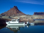
Steve, This picture is at Hite and was taken 8/1/12 at a level of 3628. Lake level is now is 3615 +-. You can see the concrete ramp. It looks like a pier is at the end and the ramp was usable then, probably for small boats only. The dirt launches are to the right and just out of the picture. The water will be muddy for a few miles downstream. |
|
| Back to top |
|
|
Marco Flamingo
Joined: 09 Jul 2015
Posts: 1155
City/Region: Seattle
State or Province: WA
C-Dory Year: 2004
C-Dory Model: 16 Cruiser
Vessel Name: Limpet
Photos: Limpet
|
| Posted: Sun Aug 28, 2016 12:21 pm Post subject: |
|
|
I saw that picture when I was researching put-in spots on Powell. The CD 16 can be put in where others fear to go, but I read that even some of the rafting companies were passing the upper ramps and going further down the lake to take out their rafts. Plus, if you are concerned about whether you can retrieve your boat there for some reason, you are in the middle of nowhere with a long drive to the next possible ramp.
Not a problem with a kayak (I've probably portaged miles and never in terrain as easy as the photo). But for a trailer launch/retrieval, I ruled out the remote launches given the lake levels.
Also when doing research on launches, I have found several comments on the web (not about Lake Powell) where boaters would complain about break-ins and gas theft when they are out overnight. Could you imagine coming back to a tow rig with an empty tank in that country? Some said that they often contacted the local sheriff and asked about theft before using a remote ramp. I've done that once and the deputy told me that there hadn't been one in the three years that she was working. Good to know.
Mark |
|
| Back to top |
|
|
texasair
Joined: 01 Feb 2009
Posts: 407
City/Region: Cypress, Texas
State or Province: TX
C-Dory Year: 1989
C-Dory Model: 22 Cruiser
Vessel Name: Bixby's Cub
Photos: Bixbys Cub
|
| Posted: Sun Aug 28, 2016 1:32 pm Post subject: |
|
|
Last year at 3608 water level It was pretty shallow and muddy with clouded water up towards Hite. At higher water levels, you could go up the Colorado, At 3640 we made it up the Colorado to "the rapids" mile 168 above the dam. and the water was much clearer near Hite.
You mention your trip for next year. Who knows what the water level may be at that time.
Powell is a different lake at different levels.
I would think your better fishing would be south of there at these water levels where the lake is a bit clearer of suspended sediments.
You might just have to put in at Halls and head up the lake.
It is only about 6 miles from Halls to the entrance to Mokai canyon. Should not take more that a few hours in a kayak. After Labor day the boat traffic up there slacks up quite a bit. If you are on a weekend, or during the summer, I would make the open lake run from Hall's up to Mokai canyon in the early AM. Less wind and less boat traffic.
You would have good water quality and there are some nice places to camp in Mokai canyon
Good luck and have fun. |
|
| Back to top |
|
|
|
 Search
 Private Messages
 Profile
 Log in
 Register
 Help
Help
