| View previous topic :: View next topic |
| Author |
Message |
SEA3PO
Joined: 02 Nov 2003
Posts: 1835
City/Region: Chester
State or Province: CA
C-Dory Year: 2003
C-Dory Model: 22 Cruiser
Vessel Name: SEA3PO
Photos: SEA3PO
|
 Posted: Mon Jul 06, 2015 11:27 am Post subject: Side scan sonar Posted: Mon Jul 06, 2015 11:27 am Post subject: Side scan sonar |
 |
|
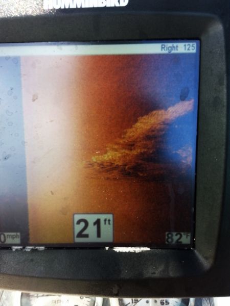
Last year I installed a Hummingbird Sonar on my working tug... and while it takes a bit to learn how to use it....it is fantastic... clear as a bell...and easy to locate stuff on the bottom....but also fish... they don't have a chance...
Last week I installed a new Lawrence High Definition Side Scan sonar on our fire boat.....and it is even better...clearer and a better picture... it has touch screen that I did not think was such a big deal when I read about it....but once I tried it I was sold.... what a fantastic machine... it works in real time...and is about as clear as anyone could want...fantastic...we wanted it for search and recovery and it is perfect...will work well..
I would think anyone serious about fishing would really want one of these... I am not much of a fisherman but it sure locates stuff on the bottom well.
Plus it's fun to use.
SEA3PO |
|
| Back to top |
|
 |
jbdba01
Joined: 18 Nov 2014
Posts: 172
State or Province: FL
|
| Posted: Mon Jul 06, 2015 6:02 pm Post subject: |
|
|
From the museum of what it's worth...I use a side imaging to spot fish but big ones...tarpon.
Here's my review of the Humminbird 598. It was written geared towards smaller craft/kayakers.
If money is available I would get the biggest screen you can afford. The 598 is a 5" screen - 10-12" would be ideal.
At the end of the day this is a tool that in my opinion that eliminates water, but buy the biggest screen you can afford.
This is review is my opinion for a Humminbird 598CI HD SI. I'm not sponsored by them - just some rambling from my perspective.
Executive Summary
As many of you are aware a dabble in the stink pot on occassion, and I have pretty much relegated it to my grouper/tarpon/trolling/Skyway boat. Frankly this Sonar unit is pretty much overkill for just about all but the most tech hungry kayakers. With the water we typically fish this unit is probably way to much a gizmo, but for the kayakers with a powerboat this might be a useful review.
Details
I had been fishing a cheap Humminbird unit that is about 8 years old. It's adequate for finding bait and what not, but I wanted a combo GPS unit that had side imaging as well as down imaging. Mainly because I felt I was missing out on some spots that I had to be on top of to "see". With side imaging I could expand my room for error by about 200'. The concept being I want to maximize my time on the water and scouting empty water is a time killer. Then there's the I'm going from TPA to the Keys via the stinkpot with my kayak, but that's another story for another day.
For the river kayak guys this might be a cool toy, but I seriously don't see it being a fit - unless that's all you do and REALLY want to get to know every inch of the water. "Hey there's a tree 50' to the port side.
This isn't a "cheap" unit, but it's certainly on the lower scale of side imaging sonar. I got mine for $800, but on Black Friday you could have picked it up for $750 from Cabelas (or the cost of a decent used kayak). I had it installed at TA Mahoneys. You can easily hit $2-3K on this stuff.
The unit itself is feels relatively sturdy, and it got a work out in some heavy chop in 15 knot winds. I had to have an extra ram sonar holder added to hold the unit, but it does give me a bunch of flexibility moving it around.
At first glance the menus are pretty darn daunting - there's a basic menu and advanced menu. Fortunately my unit came with the DVDs and manuals, but more importantly the Wonderboy unit seemed to be the best option. I cut him loose on it when the fishing was slow and like all teens with a smartphone he figured it out really quickly.
I'm really impressed with all the readouts and multiple screens for views - top imaging, side imaging, navigation...I would say there's about 8 of them. The ice fishing one was pretty useless, but fortunately you can customize the menus to drop it off the view menu.
I like the GPS unit a bunch and it's a huge improvement over my handheld which will now be relegated to the kayak (Doublebranch here I come).
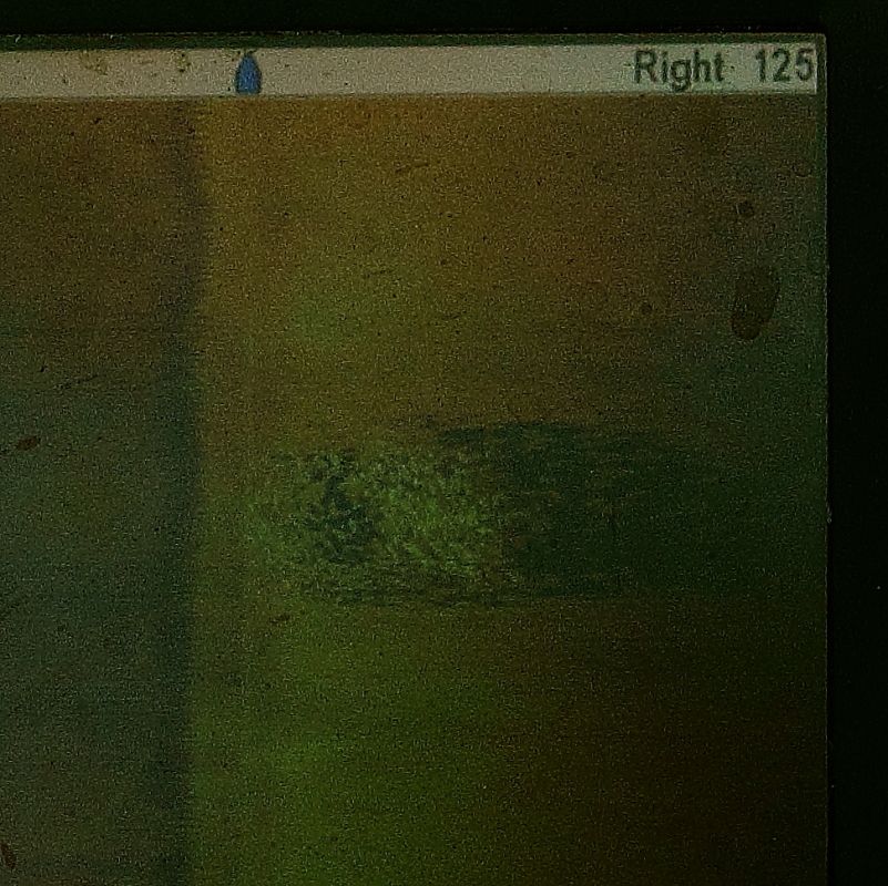
Below is a sample shot - on the starboard side is the boat ramp at Williams Park. Not that I couldn't see that, but it shows structure pretty nicely. You can see I turned the boat on the second ramp as the image curves. Each of the dots is a post and you can clearly make out the ramp and where it ends. On other shots I was able to see skeg trenches in the mud about 80' off port. The middle gold beam is where the boat is. Pretty nuts.

One major knock I have on the unit is that I had to download an opensource 3rd party viewer to look at the "movie" of the track I recorded. Seems silly that they don't provide that out of the gate - best I can figure it gives you every detail you would every want to know and they are worried about reverse engineering their product.
So far I can say I'm pleased with the unit, Wonderboy thinks it's the coolest thing ever, but I want to give it 6-12 months before I say - yeah it's really cool. Couple cons - when turning at running speed the depth may give you inaccurate results. Wonderboy said that the trolling motor caused some interference too. My transducer is on the starboardside, so port side objects are a bit more fuzzy with under way.
We did manage to catch and release several trout in less than ideal conditions (see below) - 12-15 knots, 50 degrees, but that had less to do with the unit than us getting in good water. Marking the spot was pretty easy, but heck I committed it to my memory on where we were. We did see a bunch of reds, but all had lock jaw.
For those of you thinking - wow you can really see details on there, I agree. However, spotting fish other than a bait ball with this unit will probably be tough. We did see a dolphin on the screen, and the zoom factor was pretty cool, but I'm not expecting miracles. I'm really just hoping to find structure and then go from there.
Anyway I figured I would start a placeholder for the review and add items over time.
More details...
Seems like with any marine GPS you have to buy the marine maps - and this unit was no exception. I ended up getting the Navionics Platinum + for $160 map 632 for FL (Daytona south for both coasts including the Keys).
Installation is a breeze - put the card in. Updating the data on the card itself is pretty easy - put card in laptop, create account on their website, and download some software, click update. Pretty straight forward.
The PC software is OK, and I think there's an app for smart phones, but frankly this is complicated enough. To have 3 pieces of technology running is asking for trouble. That's about 2 things more to break.
As usual you can backup waypoints, export data...they even have an online community where people (for whatever reason) post things like "big snook here". From my limited knowledge it seemed accurate. Kinda surprised to see that - perhaps they labeled Cow Creek too.
Other cool things on there include the usual, tide stations with tides, moon phases..., current stations, marinas, fuel stations...and yes restaurants. Some that were WAAAAY inland with no water access. Thought that was somewhat humorous.
On the guts of the maps you'll find the important stuff - markers, warnings, all the maritime stuff you would want - including oysters (OYS). You can "clutter/declutter" at several layers, but it was a bit klunky. On the "Xpress menu" of the 598 it's all or nothing, on the main menu its 5 levels of declutter. I'll probably go with everything for a while. Find a marina and "click" on it and you'll get all the details you want - some include phone numbers. Obviously GPS coordinates are all listed.
On the minus side the 598 does not display all the features that the Navionics chip has on it. Frankly some of it I'm thinking is just a sales pitch - do we really need 3D maps of the bay when you have the contour lines. Do you really need to see an aerial picture of the marina? Maybe you do if you have a HUGE boat, but for me it's overkill.
Basically all I wanted was there - marks of wrecks, contour lines, depth, channels...but if you REALLY want all the bells and whistles spend more $ and get the next couple models up - specifically the 800, 900, 1100, and 1100 series. All of which will probably push into the +$1300 range.
There is a web appl for maps that was useful; the depth is in meters. The interactive map is here. Unfortunately it just shows what's there and you can't get the details from tides station...considering it's price (free) it's not too bad.
To me the best way to use the sonar is to eliminate where the fish are not (or the inverse - find where the fish are). Scouting time on new water would be minimized, but you still have to understand tides, weather, and what the fish are hitting.
At the end of the day it does what I need it to - show the channels, basic contour lines, and wrecks. Get me to where the fish are and I'll take it from there. Everything else to me was a bonus. Reality is that it's a tool and nothing can substitute local knowledge, but it will keep you a) from running aground, b) getting fuel. Both of which are not a concern for kayakers, but I figured I would throw my thoughts in here for completeness anyway.
Sample daisy chaining poon (aka tarpon)
Spotting grouper (unless goliath) is still pretty hard. |
|
| Back to top |
|
|
Kushtaka
Joined: 17 Dec 2013
Posts: 648
City/Region: Cordova
State or Province: AK
C-Dory Year: 1993
C-Dory Model: 22 Cruiser
Photos: Kushtaka
|
| Posted: Tue Jul 07, 2015 12:59 pm Post subject: |
|
|
I've had some experience with Lowrance and Humminbird side/down scan. I agree that Lowrance's is somewhat better. I have the Humminbird 360, but not the lowrance spotlight scan. The 360 is expensive and cumbersome, I think the spotlight scan would be a better tool.
Otherwise, the two units are very comparable. I like the ability to use Lowrance to convert your side/downscan imagery into bathymetric basemaps for your HDS MFD. That is nice. There are third party software options that allow for you to collect sonar logs and manipulate them with GIS software, if that's your thing, to really get personal with it. These range in cost from around $100 or less one-time, to services costing nearly $3k a year. Humminbird and Lowrance are the most advanced into this utility, in my opinion, with proprietary data files output that takes sidescan sonar data, and georeferences it for you, so that any point on the image away from the boat will show a lat/long (with varying accuracy).
These features are not super valuable to everyone, but it seems that the OP might be interested in the integration of sonar logs into GIS mapping software.
The utility being the ability to review sonar logs and find objects you may have missed while operating the boat, then determine a fairly precise location and return to that position quickly and easily.
If this is your thing, there is a lot of very cool new stuff out there. |
|
| Back to top |
|
|
|
|
You cannot post new topics in this forum
You cannot reply to topics in this forum
You cannot edit your posts in this forum
You cannot delete your posts in this forum
You cannot vote in polls in this forum
You cannot attach files in this forum
You cannot download files in this forum
|
|
 Search
 Private Messages
 Profile
 Log in
 Register
 Help
Help
