| View previous topic :: View next topic |
| Author |
Message |
Pat Anderson
Joined: 02 Nov 2003
Posts: 8562
City/Region: Birch Bay, WA
State or Province: WA
C-Dory Year: 2005
C-Dory Model: 25 Cruiser
Vessel Name: Daydream
Photos: Daydream and Crabby Lou
|
 Posted: Fri Aug 18, 2006 9:31 am Post subject: Posted: Fri Aug 18, 2006 9:31 am Post subject: |
 |
|
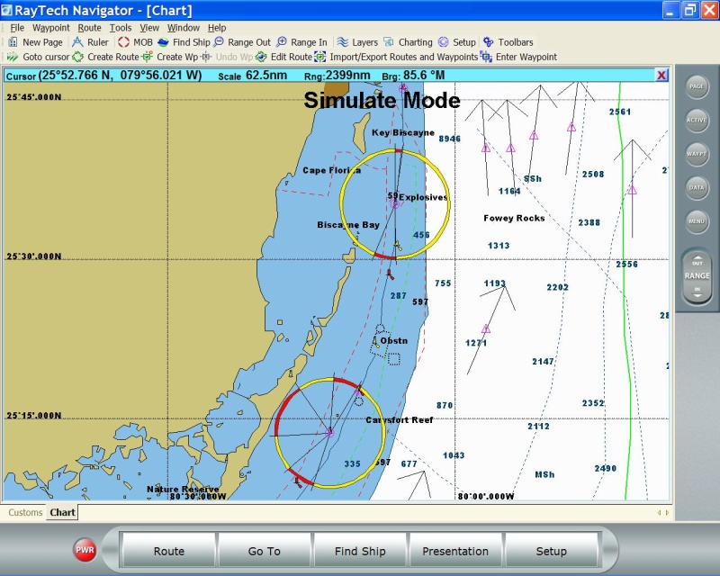
One thing I have found is pretty cool is to quickly route plan on the C-Map vector chart at the gross level with the raster charts set to 0% transparency, then to bring the raster charts up to maybe 50%, so you can see a lot more detail overlaid and drag the waypoints around to miss rocks, stay in deep water, etc. - my raster charts are the MapTech ones that came on CD with my Puget Sound and San Juan chartbooks, but I have a bunch of NOAA raster charts too, and they do have all the buoys, rocks and other detail stuff...Here is a screen shot (this is Everett to Port Ludlow):

| flapbreaker wrote: | | I keep my c-80 in the house and the boat at a storage facility so you can see why I would like to at least be able to power the unit on at home. But again it's probably not necessary. I do want to use my navionics maps from the chartplotter since it has all the bouys and so far it doesn't look like the one that comes with the raytech does but I'll keep fiddling with it. |
_________________
DAYDREAM - 2005 CD25 Cruiser (sold July 2025)
CRABBY LOU - 1991 CD16 Angler (sold 2020)
Pat & Patty Anderson, C-Brat #62!
http://daydreamsloop.blogspot.com

|
|
| Back to top |
|
 |
colobear
Joined: 23 Jan 2005
Posts: 2154
City/Region: Denver
State or Province: CO
C-Dory Year: 2006
C-Dory Model: 22 Cruiser
Photos: C-Cakes
|
| Posted: Fri Aug 18, 2006 10:05 am Post subject: |
|
|
Pat,
What kind of chartbooks do you have?? I'm interested in the raster charts. I don't have any now.
Thanks for "test driving" this product.
_________________
Patti and Barry
formerly C-Cakes, now
rving around N. America |
|
| Back to top |
|
|
flapbreaker
Joined: 26 Jan 2005
Posts: 878
City/Region: Hillsboro
State or Province: OR
C-Dory Year: 2006
C-Dory Model: 22 Cruiser
Vessel Name: Playin' Hooky
Photos: Playin' Hooky
|
| Posted: Fri Aug 18, 2006 12:14 pm Post subject: |
|
|
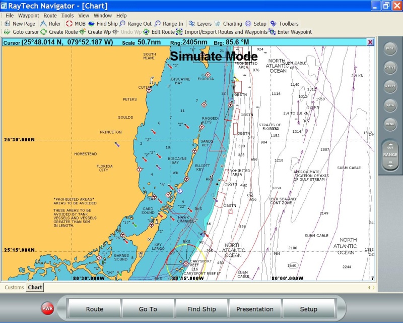
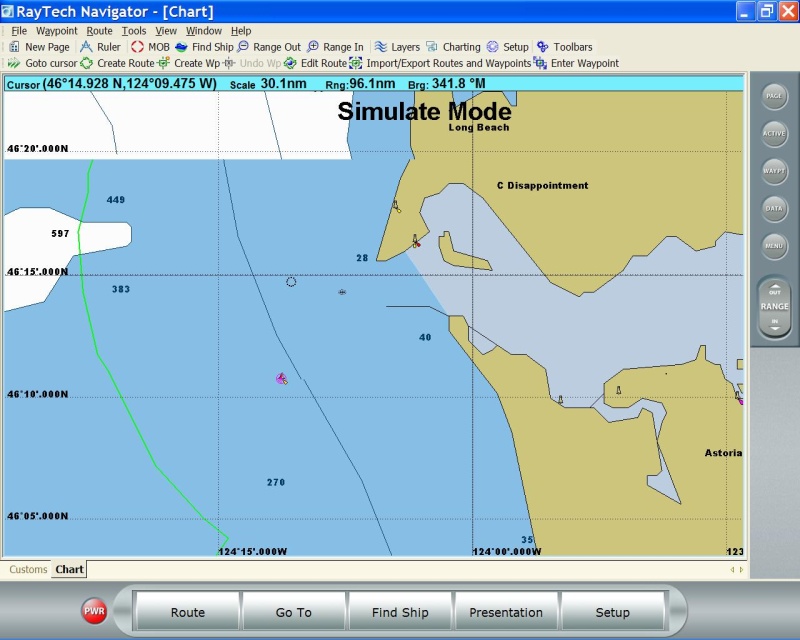
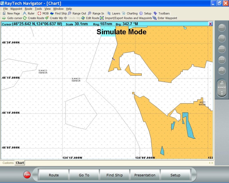
So Pat, it doesn't look like your using the default charts then because I don't have near the detail that you are getting. I've posted some comparison pictures. Two of them are from the florida location that it defualts to. Interestingly enough both cmap and navionics have much more detail in this region than the other two pictures of the Columbia river mouth. There's no tide stations or bouys to speak of listed. I can access tide data but just no tide stations on the map.
c-map
Navionics
Columbia River entrance.
c-map
Navionics
 |
|
| Back to top |
|
|
Pat Anderson
Joined: 02 Nov 2003
Posts: 8562
City/Region: Birch Bay, WA
State or Province: WA
C-Dory Year: 2005
C-Dory Model: 25 Cruiser
Vessel Name: Daydream
Photos: Daydream and Crabby Lou
|
| Posted: Fri Aug 18, 2006 1:45 pm Post subject: |
|
|
Most of the detail is on the raster charts that are overlaid over the C-Map built in vector chart - I have the raster chart transparency set to about 50%, so it appears lighter (and the raster chart does not completely hide the vector chart). I'll bet you can get the raster charts you need for the detail you want from the NOAA Raster Navigational Chart download page. An interesting note on your area, it appears the Navionics base chart is better than the C-Map...here it seems just the opposite, but whatever works!
| flapbreaker wrote: | | So Pat, it doesn't look like your using the default charts then because I don't have near the detail that you are getting. |
|
|
| Back to top |
|
|
flapbreaker
Joined: 26 Jan 2005
Posts: 878
City/Region: Hillsboro
State or Province: OR
C-Dory Year: 2006
C-Dory Model: 22 Cruiser
Vessel Name: Playin' Hooky
Photos: Playin' Hooky
|
| Posted: Fri Aug 18, 2006 4:46 pm Post subject: |
|
|
Thanks for the link. I found some raster charts that work. Much better than the supplied ones.  |
|
| Back to top |
|
|
thataway
Joined: 02 Nov 2003
Posts: 21606
City/Region: Pensacola
State or Province: FL
C-Dory Year: 2007
C-Dory Model: 25 Cruiser
Vessel Name: thataway
Photos: Thataway
|
| Posted: Fri Aug 18, 2006 6:35 pm Post subject: |
|
|
I think it would be very difficult to make a judgement on Navionics base charts being better than C maps base charts. I have chart plotters which use both. (Not Raymarine) The detail given in the "C map" base chart, is far less than what is on the basic plotters. I suspect that this is due to the fact that RayMarine stopped using C map some time ago, and what is seen here may reflect relitatively old material. Or...could it be that RayMarine is intentionally using a map with much less resolution? I have used C maps (and Navionics) for the last 5 years--since discontinuing Garmin--and found that in some places one was better than the other--both in base charts and the detailed charts.
From what you show as the C map, it might be dangerous to use that as route planning material....or I am missing some major point here.
_________________
Bob Austin
Thataway
Thataway (Ex Seaweed) 2007 25 C Dory May 2018 to Oct. 2021
Thisaway 2006 22' CDory November 2011 to May 2018
Caracal 18 140 Suzuki 2007 to present
Thataway TomCat 255 150 Suzukis June 2006 thru August 2011
C Pelican; 1992, 22 Cruiser, 2002 thru 2006
Frequent Sea; 2003 C D 25, 2007 thru 2009
KA6PKB
Home port: Pensacola FL |
|
| Back to top |
|
|
flapbreaker
Joined: 26 Jan 2005
Posts: 878
City/Region: Hillsboro
State or Province: OR
C-Dory Year: 2006
C-Dory Model: 22 Cruiser
Vessel Name: Playin' Hooky
Photos: Playin' Hooky
|
| Posted: Fri Aug 18, 2006 6:53 pm Post subject: |
|
|
| thataway wrote: | I think it would be very difficult to make a judgement on Navionics base charts being better than C maps base charts. I have chart plotters which use both. (Not Raymarine) The detail given in the "C map" base chart, is far less than what is on the basic plotters. I suspect that this is due to the fact that RayMarine stopped using C map some time ago, and what is seen here may reflect relitatively old material. Or...could it be that RayMarine is intentionally using a map with much less resolution? I have used C maps (and Navionics) for the last 5 years--since discontinuing Garmin--and found that in some places one was better than the other--both in base charts and the detailed charts.
From what you show as the C map, it might be dangerous to use that as route planning material....or I am missing some major point here. |
I didn't mean for my post to be a comparison of actual retail versions of the two products but rather a comparison of what comes with Raytech for my area. I still don't know why the florida area in both map versions has more info than for the west coast though. Maybe they deliberately included more info for florida? |
|
| Back to top |
|
|
Pat Anderson
Joined: 02 Nov 2003
Posts: 8562
City/Region: Birch Bay, WA
State or Province: WA
C-Dory Year: 2005
C-Dory Model: 25 Cruiser
Vessel Name: Daydream
Photos: Daydream and Crabby Lou
|
| Posted: Sat Aug 19, 2006 10:39 am Post subject: |
|
|
They are labeled "Maptech Waterproof Chartbook"- I have two, one is 23 pages for the San Juans, and the other is 25 pages for Puget Sound (this one is labeled "West" but it is produced by Maptech). I think each one was $50. Starting with the ones labeled "Second Edition" they include a companion CD with the pages from the chartbook and a copy of Offshore Navigator Lite software. The chartbooks are very handy for the areas they cover. But I was mistaken, the raster charts I am using are not from the Maptech CDs, they are downloaded raster charts from the NOAA site.
| colobear wrote: | Pat,
What kind of chartbooks do you have?? I'm interested in the raster charts. I don't have any now.
Thanks for "test driving" this product. |
|
|
| Back to top |
|
|
Pat Anderson
Joined: 02 Nov 2003
Posts: 8562
City/Region: Birch Bay, WA
State or Province: WA
C-Dory Year: 2005
C-Dory Model: 25 Cruiser
Vessel Name: Daydream
Photos: Daydream and Crabby Lou
|
| Posted: Sat Aug 19, 2006 11:01 am Post subject: |
|
|
Bob - I was only commenting on what is built in to the Raytech Planner distribution for base maps - for this area (Puget Sound, San Juans), the C-Map base map just has more detail than the Navionics base map. I still would not use either for navigation or the final route plan, the base maps lack most of the navigational detail required. I have no idea whether Navionics or C-Map is better generally, I have never used C-Map in a chartplotter. The Navionics Gold charts I use in the C80 are very good in my opinion. What I do for route planning is do a Q&D route very quickly on the C-Map base map at a zoom level where I can see as much as possible - might go through shallow water, over rocks or even across land! Then I zoom in and bring up the raster chart detail from the NOAA charts and start dragging waypoints around to stay in deep water, miss rocks, etc. Finally I use the el cheapo CF card to transfer the route from the computer to the C80. Works well for me, I have really just started doing this since discovering Raytech Planner.
| thataway wrote: |
From what you show as the C map, it might be dangerous to use that as route planning material....or I am missing some major point here. |
|
|
| Back to top |
|
|
thataway
Joined: 02 Nov 2003
Posts: 21606
City/Region: Pensacola
State or Province: FL
C-Dory Year: 2007
C-Dory Model: 25 Cruiser
Vessel Name: thataway
Photos: Thataway
|
| Posted: Sat Aug 19, 2006 12:07 pm Post subject: |
|
|
I will have to confess that I still do it the old fashioned way; from paper charts. A couple of years ago I was doing the planing on the computer, and saw that there were two ways to get to my destination (near Tampa Bay). What I missed, on the scale of the computer, was that one of the bridges was fixed at 19 feet! I went merrily down the waterway, until I came to this bridge. Fortunately the boat had an 18' 6" air draft, and the tide was below mean water, so with Marie sighting the clearance, we squeeked under....but ever since I have gone back to the paper charts. This problem--but in a different way was recent brought to light by Ben Ellison (Panbo): http://www.panbo.com/ in his July 25 and 26 th blogs about some ledges near "wooded Island" Maine (how many "Wooded Islands" are there? Anyway, the issue is that often small rocks or ledges are obscured by a navigational mark, or may not have been put on the chart as it was transfered from the database to digital format. This is a serious issue, which is also further documented in his archives, and a definate defect in using electronic charts for route planning.
I find that reading Ben's cutting edge blogs on small boat (OK Yacht too) electronics is fascinating reading and very thought provoking.
Please understand this is not a criticism, of what seems to be an ingenious plan, but just some thoughts about the "dangers". I do certainly agree that for any route planning a base chart is not at all satisfactory. We also all acknowlege that many "obstructions" are misplaced on the paper charts as well.
Regards, |
|
| Back to top |
|
|
Grumpy
Joined: 10 Oct 2005
Posts: 1607
City/Region: Whidbey Is
State or Province: WA
Vessel Name: Kingfisher II
Photos: Kingfisher
|
| Posted: Sat Aug 19, 2006 6:39 pm Post subject: |
|
|
Just FYI. Boeing announced Friday that it has acquired C-Map. Below is copy of press release.
SEATTLE, Aug. 18, 2006 -- The Boeing Company [NYSE: BA] today announced it has reached an agreement to acquire C-Map, a leading provider of digital maritime cartography, data services and other navigational information. C-Map will become a part of Jeppesen's marine division. Jeppesen is a wholly-owned subsidiary of Boeing Commercial Aviation Services.
"We are excited about adding C-Map to Jeppesen's existing portfolio of marine information solutions," said Lou Mancini, vice president and general manager of Commercial Aviation Services. "C-Map's broad portfolio of cartography and data services, along with its key relationships with hydrographic offices, OEMs and customers, will accelerate Jeppesen's expansion in the marine information services market."
"C-Map complements Jeppesen's strategic direction," said Mark Van Tine, Jeppesen president and chief operating officer. "It blends well with our existing marine initiatives, and complements our long-standing competencies as an information solutions provider. Together with C-Map, Jeppesen will extend to the marine market a broad range of competencies we have developed and executed upon over the last 72 years -- delivering mission-critical operational information to people who depend on it."
C-Map has significant operations throughout Europe, Australasia and the Americas.
The companies are not disclosing terms of the transaction, which will not impact Boeing's financial guidance. Completion of the transaction is subject to customary conditions and relevant authorities' approval.
For more information on C-Map, visit www.c-map.it. For more information on Jeppesen, visit www.jeppesen.com.
On edit by Da Nag
Links fixed |
|
| Back to top |
|
|
thataway
Joined: 02 Nov 2003
Posts: 21606
City/Region: Pensacola
State or Province: FL
C-Dory Year: 2007
C-Dory Model: 25 Cruiser
Vessel Name: thataway
Photos: Thataway
|
| Posted: Sat Aug 19, 2006 11:01 pm Post subject: |
|
|
Thank you for that news. This is most interesting, since Jeppeson already has purchased Nobeltec. It "rounds out" the line--having both CD/DVD and chip based GPS plotter charting.
One of the great features was that C map had people who regularly monitered the large forums (like The Hull Truth and Boater Ed) who very quickly responded to problems or errors. I hope that this type of service continues. I have been very happy with C map--I have the Max chart for the Inland US and Gulf Coast, but really haven't tried all of the full features. Interesting Max Logo! |
|
| Back to top |
|
|
Da Nag
Joined: 24 Oct 2003
Posts: 2858
City/Region: Port Angeles
State or Province: WA
C-Dory Year: 1995
C-Dory Model: 25 Cruise Ship
Vessel Name: Wilbur
Photos: Da Boats
|
| Posted: Sun Aug 20, 2006 11:36 am Post subject: |
|
|
| thataway wrote: | | One of the great features was that C map had people who regularly monitered the large forums (like The Hull Truth and Boater Ed) who very quickly responded to problems or errors. I hope that this type of service continues. |
Wish I'd known that before, as my impression of their support is not so positive.
They have their own forums, accessible from their home page, which is where I've attempted to get online support. The layout and function is terrible, and the support they provide there is of the same quality. Posts sit for months, never getting an answer. Add to that, the many years of good nuggets they contained (mostly supplied by contributors) was wiped out during a software upgrade last year, never to return. The place is a virtual ghost town now.
And their phone support has been hit/miss as well for me. When I've gotten through to a human, it's been OK. However, usually I get voicemail when calling, and they've never returned my call - I've always had to call back until somebody picks up.
I do like their charts, though...
_________________
 Will, C-Brat Nerd Will, C-Brat Nerd |
|
| Back to top |
|
|
Sea Wolf
Joined: 01 Nov 2003
Posts: 8650
City/Region: Redding
State or Province: CA
C-Dory Year: 1987
C-Dory Model: 22 Cruiser
Vessel Name: Sea Wolf
Photos: Sea Wolf
|
| Posted: Sun Aug 20, 2006 12:18 pm Post subject: |
|
|
Wow!
The new integrated GPS/Chartplotter/Map/Radar/Depth Sounder/Tea Leaves in the Galley Sink Systems seem overwhelming and unnecessarily complex.
Glad I'm on an inland lake with VFR and paper charts (only when needed).
Will check back in in 2025 (if I'm still alive) to see if the market shake out and further developments have made the systems more user friendly!
KISS, KISS !
Joe.
_________________
Sea Wolf, C-Brat #31
Lake Shasta, California
  
"Most of my money I spent on boats and women. The rest I squandered'. " -Annonymous |
|
| Back to top |
|
|
thataway
Joined: 02 Nov 2003
Posts: 21606
City/Region: Pensacola
State or Province: FL
C-Dory Year: 2007
C-Dory Model: 25 Cruiser
Vessel Name: thataway
Photos: Thataway
|
| Posted: Sun Aug 20, 2006 2:32 pm Post subject: |
|
|
Joe,
You left out the Real time weather via XM satellite (or was that Garmin...?) I always just looked out the window for lightning and sent the dog outside to see if she was wet or not for rain.
Seriously, C map Amy and another person were right on top of problems which were identified. Based on input from the Trawler list/via Boat fix, with some personal input, C map changed their Bahamas Database from What DMA (or what ever it is called this week) was using and purchased the right to the Lewis Explorer Database, and then integrated this into all of the Bahamas charts. I found that both navigational issues, POI and functional issues were quickly resolved. There have been several generations of the C map planner; the most recent one seems to work quite well.
There is a place for the integrated systems--but I do believe that some people who have beginning knowlege tend not to understand the weaknesses and dangers of the integrated systems. I prefer separate screens. I am not convinced that the transparent charts really add any level of safety or speed to route plotting. That is why I still take a paper chart, protractor, ruler/triangle and dividers in planning my routes. I do believe that for long route planning, either coast wise or oceanic there is something to be said for the electronic plotting--but there are still regular reports of boats hitting reefs in the S. Pacific, because the scale was wrong, the Datum was incorrect, the chart was wrong, or there was too much "declutter". |
|
| Back to top |
|
|
|
|
You cannot post new topics in this forum
You cannot reply to topics in this forum
You cannot edit your posts in this forum
You cannot delete your posts in this forum
You cannot vote in polls in this forum
You cannot attach files in this forum
You cannot download files in this forum
|
|
 Search
 Private Messages
 Profile
 Log in
 Register
 Help
Help
