| View previous topic :: View next topic |
| Author |
Message |
hardee
Joined: 30 Oct 2006
Posts: 12637
City/Region: Sequim
State or Province: WA
C-Dory Year: 2005
C-Dory Model: 22 Cruiser
Vessel Name: Sleepy-C
Photos: SleepyC
|
 Posted: Sun May 04, 2014 6:56 pm Post subject: Magnetic vs True North for Electronic Nav Instrument Setting Posted: Sun May 04, 2014 6:56 pm Post subject: Magnetic vs True North for Electronic Nav Instrument Setting |
 |
|
This is something that has puzzled, perplexed and petrified me at times. We know there are both magnetic and true north settings available on our electronic devices. And, I think, most of us know that we can't mix those settings from device to device (VFH to Plotter or KVH to plotter, or GPS to VHF), so which one makes the most sense to use for all the devices, all the time?
Why is one better than the other, or easier to use, if it is?
It seems to me that :true" might be easier to correlate with paper IF you still use paper.
I'm curious what you are using, and why, if you care to share.
Thanks,
Harvey
SleepyC 
_________________
Though in our sleep we are not conscious of our activity or surroundings, we should not, in our wakefulness, be unconscious of our sleep. |
|
| Back to top |
|
 |
smittypaddler
Joined: 30 Jun 2004
Posts: 337
City/Region: Neenah, Wisconsin
State or Province: WI
C-Dory Year: 2004
C-Dory Model: 22 Cruiser
Vessel Name: Na Waqa
|
| Posted: Sun May 04, 2014 8:29 pm Post subject: I use true north, mostly |
|
|
| All my GPS devices report headings relative to true north. Typically I'll get on the desired heading using a GPS device, such as my chart plotter, then I'll check the heading on my magnetic compass, which of course is almost never is the same, given magnetic deviation and variation. Then I'll follow that magnetic compass heading, only because the magnetic compass shows more quickly if I vary off course than the GPS unit does. |
|
| Back to top |
|
|
nordicstallion
Joined: 16 Dec 2007
Posts: 380
City/Region: Crescent City
State or Province: CA
C-Dory Year: 2004
C-Dory Model: 19 Angler
Vessel Name: Rylee Rose
Photos: Rylee Rose
|
| Posted: Sun May 04, 2014 8:31 pm Post subject: |
|
|
| Declination is set on my compass so I'm going with magnetic, but that's just me! Vern |
|
| Back to top |
|
|
nordicstallion
Joined: 16 Dec 2007
Posts: 380
City/Region: Crescent City
State or Province: CA
C-Dory Year: 2004
C-Dory Model: 19 Angler
Vessel Name: Rylee Rose
Photos: Rylee Rose
|
| Posted: Sun May 04, 2014 8:32 pm Post subject: |
|
|
| Declination is set on my compass so I'm going with magnetic, but that's just me! Vern |
|
| Back to top |
|
|
digger
Joined: 02 Nov 2003
Posts: 496
City/Region: Spokane
State or Province: WA
C-Dory Year: 1993
C-Dory Model: 22 Angler
Vessel Name: C-Sik
Photos: Snoopy-C
|
| Posted: Sun May 04, 2014 8:33 pm Post subject: |
|
|
| I guess I will stick my neck out first. I always have used the true settings for gps and for map reading or planning of routes. It has been easier for me to use the parallel rulers,etc using the true north lat/long lines. I have noted compass reading when I am going offshore so in case of instrument failure I can add the 180 to get back to visual shore landmarks. |
|
| Back to top |
|
|
colobear
Joined: 23 Jan 2005
Posts: 2154
City/Region: Denver
State or Province: CO
C-Dory Year: 2006
C-Dory Model: 22 Cruiser
Photos: C-Cakes
|
| Posted: Sun May 04, 2014 8:38 pm Post subject: |
|
|
Our chartplotter is set to display magnetic north, the radio is set to display true north, that allows me a quick verification of declination. I think either will work fine, just depends on what you get used to.I'm sure there is some official way to go though. And, we use course-up display on the chartplotter. I prefer that. Our backup IPad is magnetic with north up (for navionics charts at least). I get used to looking back and forth and like the options.
_________________
Patti and Barry
formerly C-Cakes, now
rving around N. America |
|
| Back to top |
|
|
journey on
Joined: 03 Mar 2005
Posts: 3599
City/Region: Valley Centre
State or Province: CA
C-Dory Year: 2005
C-Dory Model: 25 Cruiser
Vessel Name: journey on
Photos: Journey On
|
| Posted: Sun May 04, 2014 9:02 pm Post subject: |
|
|
The GPS and a magnetic compass/flux gate use different methods to calculate direction or heading. Their native output is in 2 equivalent references: true for GPS and magnetic for compass.
The GPS uses geometry, based on satellite orbits to find position on a globe and then differences this position to find direction. So it's native direction/heading reading is True North.
A compass and/or flux gate uses the earths magnetic field to establish a pointing direction directly with respect to the earths magnetic field. Unlike GPS it doesn't give you a position but a heading relative to the magnetic field, or Magnetic North.
So those are 2 different heading vectors related by a fixed transformation, between true and magnetic. And of course this transformation varies with respect to your position on earth. Both are equally valid as long as you accept the difference; once you do, there is no real difference between the two.
The traditional method of using heading is magnetic since the magnetic compass was the primary measuring device. Now with GPS we have a choice of 2 equivalent headings. And electronic charts will give you either, but since they get their heading largely from GPS, one can claim that true heading is native to those charts. Either a magnetic course or true course can be plotted on a paper or electronic chart, they're equivalent.
The one to use is the one with which you're most comfortable. The only requirement is that one is consistent, you can't jump between true and magnetic without getting in trouble. So each statement as to which is the right one is true for that person. I, being brought up on paper charts and magnetic compasses complete with hand plotting, tend to use magnetic. And that choice is only correct for me.
It's sorta like twin vs single engines; both will move and steer the boat. The correct one is the choice made for a specific boat by the owner.
Boris |
|
| Back to top |
|
|
hardee
Joined: 30 Oct 2006
Posts: 12637
City/Region: Sequim
State or Province: WA
C-Dory Year: 2005
C-Dory Model: 22 Cruiser
Vessel Name: Sleepy-C
Photos: SleepyC
|
| Posted: Mon May 05, 2014 12:03 am Post subject: |
|
|
Oh great, this could be another twins / singles style. (Well I knew there would be differences) For me, with everything printed (charts) using North up, or True north, it seems easier to use that for a standard.
What brings this up is that I am running into a situation where my auto pilot is having a hard time finding which way to go, and it is apparently from having more than one directional input. This may be due to different "rates of output" from more than one GPS and direction sensor (flux gate compass) getting a signal into the AP somehow (possibly via the MFD.)
So for now, I'm thinking I want to be sure everything is all looking at the same "north", and for me, if they will, they should be all saying the same signal, "North is True".
Boris, thanks for the excellent explanation. You are right, they both will work --> " | Quote: | | It's sorta like twin vs single engines; both will move and steer the boat. The correct one is the choice made for a specific boat by the owner." |
Barry, I like the Course Up for the plotter as well. I'm curious, why do you want, and what do you use the verification of declination for?
Digger, I have the plotter set at "true" and the compass has been at magnetic. I have not been as good about keeping that reciprocal setting because I have kept a small, handheld Garmin working with a tracking feature going. It has 12 hours of battery backup should the electric power fail. (Of course if that happens, I may have more to worry about than which way to go.)
Vern, If all is set on Magnetic, that should work well.
Thanks for the feed back. I'm still curious as to the "logic" of why the choices are made. If there is a particular reason for your choice (ie: it makes it easier to follow on a paper chart, or this is the only option between the GPS and my MFD that works.)
Barry likes options. Frankly that would confuse me, but it works for him and he gets from point to point well. Digger likes the true because it lines up on paper with the lat/long lines.
Thanks again,
Harvey
SleepyC |
|
| Back to top |
|
|
hardee
Joined: 30 Oct 2006
Posts: 12637
City/Region: Sequim
State or Province: WA
C-Dory Year: 2005
C-Dory Model: 22 Cruiser
Vessel Name: Sleepy-C
Photos: SleepyC
|
| Posted: Mon May 05, 2014 12:03 am Post subject: |
|
|
Sorry -- Duplicate post.
Harvey
SleepyC
 |
|
| Back to top |
|
|
Aurelia
Joined: 21 Aug 2009
Posts: 2335
City/Region: Gig Harbor
State or Province: WA
Photos: Aurelia
|
| Posted: Mon May 05, 2014 12:12 am Post subject: |
|
|
| nordicstallion wrote: | | Declination is set on my compass so I'm going with magnetic, but that's just me! Vern |
Careful with that... If you have set the Declination on your compass, then you adjusted to create a True north reference by factoring in about (16 degrees east currently) for our area. That means your compass is giving you a True north bearing and not a magnetic north bearing.
The whole question relates to consistency more that anything else.
I have generally used and preferred going with a Magnetic north reference for all of my travels both land and sea.
I do not typically use paper maps for measuring anymore but I still prefer to use the Magnetic north reference because it does not rely on a second factor. GPS units and compasses and most electronic devices that provide a heading/bearing should be capable of using Magnetic instead of True.
a True north reference requires a local declination setting and now you need to make sure all of those settings are the same on all of your toys so that they are all on the same "page". Some devices are limited in their declination resolution and may not be able to match another device. Others have an "auto setting" which can be more of a problem than a solution because that one could change without you doing anything. If you travel a significant distance, the declination changes but if you are still using the same toys and they all agree, you may be fine. Just don't tell another person a heading to follow over the radio if you are knowingly using a very different reference than they might be.
That brings me to another reason why I prefer Mag.
Radio talk....
If I ask.....what is the heading to the lighthouse?
and you answer.....137 True
I am wondering what declination you have set and will likely ask you that followup question
If I ask.....what is the heading to the lighthouse?
and you answer.....137 Magnetic
I don't have any questions left to ask
But, as soon as a new toy comes to the party or a new map is used to navigate by, that consistency is back in question and the new arrival needs to match the rest if you are navigating with it. Paper maps don't have settings so you would need to set all your toys to match the map if you want them to all play together.
If you are boating with electric charts and only using paper maps for reference and planning. Just take your pick of systems and keep it consistent unless, like Barry, you want to see the declination difference by using a couple of units with different settings on purpose.
Greg
_________________
Greg, Cindie & Aven
Gig Harbor
Aurelia - 25 Cruiser sold 2012
Ari - 19 Cruiser sold 2023
currently exploring with "Lia", 17 ft Bullfrog Supersport Pilothouse |
|
| Back to top |
|
|
colobear
Joined: 23 Jan 2005
Posts: 2154
City/Region: Denver
State or Province: CO
C-Dory Year: 2006
C-Dory Model: 22 Cruiser
Photos: C-Cakes
|
| Posted: Mon May 05, 2014 2:07 am Post subject: |
|
|
Harv,
I like the true north on the radio and magnetic on the plotter so when my chart indicates an area of local magnetic disturbance I can glance up to see any effect, nothing critical, other than that No real reason, just what I am used to. |
|
| Back to top |
|
|
thataway
Joined: 02 Nov 2003
Posts: 21469
City/Region: Pensacola
State or Province: FL
C-Dory Year: 2007
C-Dory Model: 25 Cruiser
Vessel Name: thataway
Photos: Thataway
|
| Posted: Mon May 05, 2014 4:19 pm Post subject: |
|
|
When we used to use the compass for navigation, we always computed course relative to magnetic bearing or course. We plotted the true course and then corrected for declination and variation. Today we rarely use the compass--the exception is taking a bearing on an object, or the course out of a harbor should we have to leave suddenly, before the boat begins to move--that we have the proper course. (Now the latest GPS have a update rate of 10 Hz--that is the GPS heading and position is recalculated 10 times a second, rather than once a second, and is far more accurate. )
The declination changes at any one place at varying rates--and even if you are always in the same place, you need to re-calculate the variation. It would seem to be difficult to always to rotate the compass as you travel or come into new areas. The deviation (due to effects of magnetic fields on the boat), also changes, as you rotate the compass, and a new diagram has to be made or the compass re-calibrated. I certainly would always want the
the compass to be reading compensated magnetic, or at least have a deviation diagram available for the compass so you can tell what the actual magnetic heading is. Generally the C Dory compass is fairly easy to compensate--unless you start putting electronics around it, wires which carry current some times, and speakers nearby--as many of us do
..
Even for those of you who boat in the PNW, as you go up the inland passage the declination changes from Seattle today: 16° 12' 20" E changing by 10.8' W per year
to Juneau AK: 20° 14' 26" E changing by 19.3' W per year.
A very handy web site is at: http://www.ngdc.noaa.gov/geomag/geomag.shtml You can find your declination by clicking on "Declination" on the first set of links--and this takes you to a page where can enter your Zip Code, City, or Lat and Log.
http://www.ngdc.noaa.gov/geomag-web/#declination
Also I use a sun compass and tables to check my compass--and that is referenced to magnetic readings.
With the GPS, for me it just more intuitive to use true. I do like to run with course up display, that way I can see on the chart, what I see relative to my radar and visual fields.
_________________
Bob Austin
Thataway
Thataway (Ex Seaweed) 2007 25 C Dory May 2018 to Oct. 2021
Thisaway 2006 22' CDory November 2011 to May 2018
Caracal 18 140 Suzuki 2007 to present
Thataway TomCat 255 150 Suzukis June 2006 thru August 2011
C Pelican; 1992, 22 Cruiser, 2002 thru 2006
Frequent Sea; 2003 C D 25, 2007 thru 2009
KA6PKB
Home port: Pensacola FL |
|
| Back to top |
|
|
journey on
Joined: 03 Mar 2005
Posts: 3599
City/Region: Valley Centre
State or Province: CA
C-Dory Year: 2005
C-Dory Model: 25 Cruiser
Vessel Name: journey on
Photos: Journey On
|
| Posted: Mon May 05, 2014 6:08 pm Post subject: |
|
|
Well, Bob, I certainly agree with what you do, though I'm not as careful. You knew that, huh? However, as we cruise along on Journey On, I have plenty of time to think about how we're steering the boat, and I've come to a couple of conclusions. One conclusion is that the compass course isn't that important to me, but arriving at the correct destination is. I select a planned route, point Journey On in the direction the electronic chart plotter/GPS tells me and then steer by the crosstrack error. Any inaccuracies in Journey On's course are automatically corrected.
Journey On has 3 course indicators on board; 2 magnetic and one GPS. The magnetic indicators are a visual steering compass and the autopilot fluxgate. And of course the GPS is the GPS.
Normally when we're cruising, I set a waypoint, or even a whole route, then point the boat to where the GPS display/plotter tells me by setting that direction on the autopilot. Then I steer not by any direction but by the cross track error and adjust the autopilot setting accordingly. Since the autopilot uses magnetic, that's where I set the GPS. Yes, it would be easier to just set the autopilot to track the desired course by using data directly from the GPS, but that doesn't work as easily as it sounds. And I really don't care what reading the autopilot is giving, since I'm using cross track error which is neither magnetic or true. However, I do need consistency/stability in the reading.
Another mode used, for example, is when we come back from Santa Cruz Island around noon and the downwind swells are more than the autopilot can handle. I manually steer and the GPS indication isn't fast enough, so I use the magnetic compass to try to hold a reasonably straight course. I update my course again by using the cross track error. Again, compass accuracy isn't important, which is good because Journey On is usually bouncing all over the place. Again, consistency/stability in the compass reading is important and the magnetic devices have this.
So you can see that the steering criteria is to minimize the cross track error and drive it to 0 when we arrive at our destination, not before. In order to minimize confusion and panic, I try to make sure all devices read in the same reference frame: magnetic. And there is no need to calibrate either magnetic device, because using cross track error automatically compensates for any deviation between the 3 devices, as long as the GPS doesn't screw up.
This change in the way we used to navigate and the new way has amazed me. Years ago, I would set a compass course to Avalon, allow for the southward current and wait until Avalon appeared and then steer to the breakwater. Now I just set the waypoint navigation and adjust the autopilot heading and wait until we're there, completely different. Yes, this means I need an operating, active GPS and autopilot. I do have paper charts on board, but neither the plotter, GPS or autopilot has quit in mid-flight yet. And I sit there and think that the steering compass isn't the essential instrument it used to be.
Even if I'm doing manual piloting (gasp,) I point the boat on an approximate desired course and update it by visual aids, certainly more accurate than dead reckoning.
Oh, and now we have radar to see if anything big is approaching.
Time have changed. And I enjoy thinking about how they've changed. So regard this post as just a bunch of freebe comments.
Boris |
|
| Back to top |
|
|
thataway
Joined: 02 Nov 2003
Posts: 21469
City/Region: Pensacola
State or Province: FL
C-Dory Year: 2007
C-Dory Model: 25 Cruiser
Vessel Name: thataway
Photos: Thataway
|
| Posted: Mon May 05, 2014 9:28 pm Post subject: |
|
|
Hi Boris,
Interesting thoughts as always!--and when I had boats with auto pilots and GPS, I did steer by cross track error. I have not had a auto pilot on any of the C Dorys. Why no auto pilot? Down on the Gulf, I generally am going along the ICW, or toward a fishing location--with a fair amount of boating traffic, thus I am hand steering. Powell, Central Calif, So. Calif and PNW--pretty much the same way. I misspent a lot of my youth watching a compass in a slow sailboat. I guess that the psychology of watching the cross track error when hand steering not appeal to me. But I find a lot of my "navigation" is watching the water, other traffic, and an occasional glance to see where we are in relation to the course line on the GPS. I do run two chart plotters--one is set for the scale of that segment of the route. The other is set on a much more magnified scale--and I glance back and forth between them. |
|
| Back to top |
|
|
hardee
Joined: 30 Oct 2006
Posts: 12637
City/Region: Sequim
State or Province: WA
C-Dory Year: 2005
C-Dory Model: 22 Cruiser
Vessel Name: Sleepy-C
Photos: SleepyC
|
| Posted: Tue May 06, 2014 12:38 am Post subject: |
|
|
| colobear wrote: | Harv,
I like the true north on the radio and magnetic on the plotter so when my chart indicates an area of local magnetic disturbance I can glance up to see any effect, nothing critical, other than that No real reason, just what I am used to. |
Interesting thought Barry. Had not heard/thought of that before.
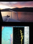
Borris and Dr Bob, nice discussion. Thanks for the reasoning. I have not used the crosstrack error much, but that sure makes sense. As Dr Bob mentions I prefer to run a split screen on the MFD, with a close in scale, (1-6 miles, depending on where and conditions and then a second screen which includes the destination waypoint, to show progress.)
Harvey
SleepyC |
|
| Back to top |
|
|
|
|
You cannot post new topics in this forum
You cannot reply to topics in this forum
You cannot edit your posts in this forum
You cannot delete your posts in this forum
You cannot vote in polls in this forum
You cannot attach files in this forum
You cannot download files in this forum
|
|
 Search
 Private Messages
 Profile
 Log in
 Register
 Help
Help
