| View previous topic :: View next topic |
| Author |
Message |
Capn Jack
Joined: 01 Oct 2007
Posts: 525
City/Region: La Conner
State or Province: WA
C-Dory Year: 1988
C-Dory Model: 16 Angler
Vessel Name: Pocket Yacht
Photos: Pocket Yacht
|
 Posted: Tue Nov 13, 2007 11:44 pm Post subject: MS Streets Posted: Tue Nov 13, 2007 11:44 pm Post subject: MS Streets |
 |
|
When ever we are at anchor in a harbor, with visiters, I love to fire up MS Streets on the laptop and show them the little car in the water at our position. 
I was using the MS Puck that came with "Streets" but I was bothered by frequent "Drop outs". Now I'm using my old Garmin 45XL. with a "card" serial port. I'll look into that Garmin Puck.
Anyone using Captain's out there? Don't you just love the message "You have just exceeded 250K" when you go from one chart to another?  |
|
| Back to top |
|
 |
Sea Wolf
Joined: 01 Nov 2003
Posts: 8650
City/Region: Redding
State or Province: CA
C-Dory Year: 1987
C-Dory Model: 22 Cruiser
Vessel Name: Sea Wolf
Photos: Sea Wolf
|
| Posted: Wed Nov 14, 2007 1:26 am Post subject: |
|
|
I think Roger (Dreamer) set his laptop and plotter up in what I would consider the ideal mode:
The chartplotter is set up for the Helmspersons view, and the laptop it set up for use by the person in the portside forward facing seat that is the "Navigator".
This not only makes more sense considering the physical dimensions and capabilities of the two units, but it also helps train and utilize the skills of the other person, a great plus for safety in the event of the disability of the Helmsperson.
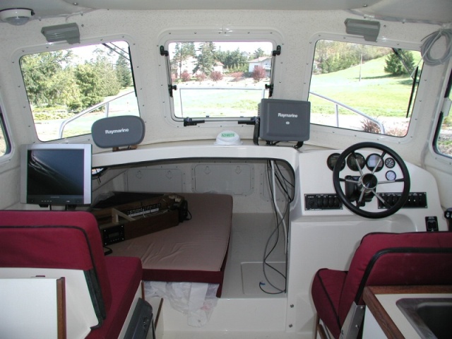
Dreamer's Helm and Navigation station.
Joe. 
_________________
Sea Wolf, C-Brat #31
Lake Shasta, California
  
"Most of my money I spent on boats and women. The rest I squandered'. " -Annonymous |
|
| Back to top |
|
|
Dene
Joined: 27 Nov 2007
Posts: 444
City/Region: Kalama
State or Province: WA
Vessel Name: Fear Naut & Terra-Sea-Ta
|
| Posted: Sun Dec 02, 2007 10:43 pm Post subject: |
|
|
Just thought I'd throw my 2 bits re. the original subject of using a laptop as a chartplotter. I use both a Garmin chartplotter, located above the helm, and a laptop which is located to my left, strapped into the passenger seat. facing me. The Garmin is zoomed in close so I can keep track of shoals and sandbars. The laptop is on a larger scale, so I can have a perspective of where I'm at, in terms of my final destination. I use an old version of Nobeltec that I got for cheap off E-bay. Works great, especially with the new Sprint USB broadband receiver, which serves both as a on-line and GPS receiver. No need to put the hockey puck out anymore.
Hope this helps.
-Greg |
|
| Back to top |
|
|
blackfish
Joined: 05 Aug 2007
Posts: 153
City/Region: saltair
State or Province: BC
C-Dory Year: 2004
C-Dory Model: 22 Cruiser
Vessel Name: raincoast
Photos: Raincoast
|
| Posted: Mon Dec 03, 2007 12:23 am Post subject: |
|
|
thanks Gerg
I think I've narrowed down my electronics upgrade
new chip for my garmin 182c with my area so it can be used for backup
stand alone fish finder Lowrance or Humminbird
laptop as my main chartplotter
could up you explain this Sprint USB broadband receiver is this cell phone thing? |
|
| Back to top |
|
|
RJD Wannabe
Joined: 16 Jun 2007
Posts: 244
City/Region: Elk Grove
State or Province: CA
|
| Posted: Mon Dec 03, 2007 12:53 am Post subject: |
|
|
anyone know of any decent computer monitors that'll handle the marine environment?? I have a couple of extra mac minis, that plus a GPS puck may go along way with a monitor
_________________
Soon to join C-Dory owners |
|
| Back to top |
|
|
thataway
Joined: 02 Nov 2003
Posts: 20814
City/Region: Pensacola
State or Province: FL
C-Dory Year: 2007
C-Dory Model: 25 Cruiser
Vessel Name: thataway
Photos: Thataway
|
| Posted: Mon Dec 03, 2007 1:31 pm Post subject: |
|
|
If you want a high brilliance, marinized moniter, it will be very expensive. (thousands) But, there are some good high resolution screens which will do fine in the marine environment. many of these have a 12 volt power supply, so they will run off the 12 volt DC system, with appropiate plugs. I would keep the electronics on a separate battery to avoid engine start up spikes etc. The tower type of computer will fail in the salt air environment much faster than a lap top or a LCD monitor. It is best to run the units to keep them warm and dry.
How accurate is the GPS on the Cell phone? I understand that many of these use triangulation, rather than an actual GPS reciever. Does the card contain a GPS reciever? How does this interphase with the Nobeltech software? Finally, how do you use the internet connection with the navigation? I can see that when Active Captain goes on line, it would be quite valuable. Finally, how is the reception on the water and what does the speed do as you move into poor reception areas? I find that even at our home, only 0.7 mile seaward from the cell tower, that the aircards do not work well because the signal is beamed inland and along the highways, since there are few homes seaward of the towers. I don't see any problem with putting out a hocky puck GPS--they work well anywhere in the C Dory as long as there is no metal between the puck and the sky.
_________________
Bob Austin
Thataway
Thataway (Ex Seaweed) 2007 25 C Dory May 2018 to Oct. 2021
Thisaway 2006 22' CDory November 2011 to May 2018
Caracal 18 140 Suzuki 2007 to present
Thataway TomCat 255 150 Suzukis June 2006 thru August 2011
C Pelican; 1992, 22 Cruiser, 2002 thru 2006
Frequent Sea; 2003 C D 25, 2007 thru 2009
KA6PKB
Home port: Pensacola FL |
|
| Back to top |
|
|
RJD Wannabe
Joined: 16 Jun 2007
Posts: 244
City/Region: Elk Grove
State or Province: CA
|
| Posted: Mon Dec 03, 2007 2:25 pm Post subject: |
|
|
| Bob, thanks. You are getting closer to what I'm thinking, a mac mini, a 12v decent monitor, gps puck that I bring on the boat and take off with me. Can also play movies. Hook into speakers. Alotta power for little $$. An inverter may be an answer as 110v opens many doors and they are not power hogs. My mac laptop won't run on 12v, I have an inverter for the car. |
|
| Back to top |
|
|
Dene
Joined: 27 Nov 2007
Posts: 444
City/Region: Kalama
State or Province: WA
Vessel Name: Fear Naut & Terra-Sea-Ta
|
| Posted: Mon Dec 03, 2007 3:18 pm Post subject: |
|
|
| thataway wrote: | If you want a high brilliance, marinized moniter, it will be very expensive. (thousands) But, there are some good high resolution screens which will do fine in the marine environment. many of these have a 12 volt power supply, so they will run off the 12 volt DC system, with appropiate plugs. I would keep the electronics on a separate battery to avoid engine start up spikes etc. The tower type of computer will fail in the salt air environment much faster than a lap top or a LCD monitor. It is best to run the units to keep them warm and dry.
How accurate is the GPS on the Cell phone? I understand that many of these use triangulation, rather than an actual GPS reciever. Does the card contain a GPS reciever? How does this interphase with the Nobeltech software? Finally, how do you use the internet connection with the navigation? I can see that when Active Captain goes on line, it would be quite valuable. Finally, how is the reception on the water and what does the speed do as you move into poor reception areas? I find that even at our home, only 0.7 mile seaward from the cell tower, that the aircards do not work well because the signal is beamed inland and along the highways, since there are few homes seaward of the towers. I don't see any problem with putting out a hocky puck GPS--they work well anywhere in the C Dory as long as there is no metal between the puck and the sky. |
Addressing your comments about monitors first, we tinted our windows in the 22 footer, for privacy and to reduce glare. It really helps with the laptop monitor. No trouble seeing it in any sky conditions.
As for the Sprint receiver, I believe it is a true gps instead of a triangulation. It does the whole sattelite acquiring process when it's activated. I've tested both with MS Streets and Nobeltec and it works better than the Garmin hockey puck. It's nice that I don't have to use the Garmin Spanner program, which caused lockups at times. I don't have these problems with the Sprint device. It was plug and play. I haven't touched the puck since I got it.
We're able to be on-line and have the gps work simultaneously, both on water and in the RV. When cruising, it's not unusual for my wife or I to grab the laptop and check the internet, while the gps/chartplotter works in the background. Again, the laptop as my chartplotter is a secondary source. My Garmin 172 or Standard Horizon (in my 30 foot boat) are primary chartplotters.
Regarding internet speed, it is DSL fast. I've used it extensively in Western Washington and even on the coast. Rarely have I experienced slow or erratic connections. You might want to check their website about this. They have a nice map that indicates coverage areas.
As for power source, I find the 12V cigarette lighter source in my 22 footer to be erratic, especially when the laptop is on full power. I prefer to use a Xanex portable 400 W inverter while underway, keeping the laptop battery fully charged, in case all boat power is lost.
Finally....what is Active Captain?
-Greg
Last edited by Dene on Mon Dec 03, 2007 3:38 pm; edited 2 times in total |
|
| Back to top |
|
|
Dene
Joined: 27 Nov 2007
Posts: 444
City/Region: Kalama
State or Province: WA
Vessel Name: Fear Naut & Terra-Sea-Ta
|
| Posted: Mon Dec 03, 2007 3:23 pm Post subject: |
|
|
| blackfish wrote: | thanks Gerg
I think I've narrowed down my electronics upgrade
new chip for my garmin 182c with my area so it can be used for backup
stand alone fish finder Lowrance or Humminbird
laptop as my main chartplotter
could up you explain this Sprint USB broadband receiver is this cell phone thing? |
I think your choices are wise. For depth, I rely on the Garmin FF and the dash depthfinder. I like have redundant systems.
For chartplotting, I recommend using your Garmin as primary. Much brighter monitor than a laptop and not succeptible to water or wave action.
As for the Sprint card, please refer to my comments to Dr. Bob.
-Greg |
|
| Back to top |
|
|
thataway
Joined: 02 Nov 2003
Posts: 20814
City/Region: Pensacola
State or Province: FL
C-Dory Year: 2007
C-Dory Model: 25 Cruiser
Vessel Name: thataway
Photos: Thataway
|
| Posted: Tue Dec 04, 2007 12:14 am Post subject: |
|
|
Active captain: http://www.activecaptain.com/index.php is a service by C Brat member Jeff Siegel. Jeff has cruised in his Defever 53 for the last few years, and found the need for up-to-date information on marinas and anchorages. Jeff is also the author of "Outdoor Navigator".
From the web site:
"A community as passionate about boating as you are.
Benefit from the knowledge and experience of a worldwide community of boaters. Gain information from others. Contribute your knowledge to the community. It's all about content, communications, and community.
ActiveCaptain currently has a visual database of over 9,000 marinas and a growing database of anchorages. "Local knowledge" and other points of interest are coming soon. To be successful we need your help."
Jeff is doing this as a service to the boating community and building the database currently. I suspect that Jeff will chime in, but as I understand the plan , one of the main uses will be to access the database and maps on line as it developes.
Thanks for the information on the GPS. It does not appear that there is good coverage in my area from Sprint--there are "future" towers about 5 and 7 miles from my house--I can barely get the Verizon cell voice which is 0.7 miles from the house. The Sprint speed expected in this area is 50-70 Kbps where available from Sprint. My cable is running 2 Mbps. It appears that there is much better coverage in Washington. Looking at the US, there appears to be fairly good Sprint high speed coverage in larger cities, but there are lots of gaps. Generally those who cruise in mid America and the East Coast have found that Verizon is the best data plan.
We have tinted the pilot house windows of only one boat--and that we didn't steer from the pilot house often. The reason is that you have loss of night vision with the tinting; if there is enough tint, it will reduce the dim lights at night significantly. We have used computers aboard since 1982 and have found that using a hood for the moniter, made of mat black foam board or poster board is satisfactory even in the full sunlight(as long as the sunlight is not directly on the screen--like on a flying bridge).
The varibility of the 12 volts, is the reason that I suggest a second electronics battery. It might be interesting to moniter the battery voltage going to an inverter. Often the wiring to the console is too small (allowing voltage drop) for heavier power draws. We have the inverter near the dedicated battery bank, and run short heavy cable runs--then energize 110 volt plugs from the central inverter. (1500 watts--but for a computer or moniter it will require much less power) The inquiry about moniters apparently involved a separate moniter from the Mini Mac computer. If you can run the moniter on 12 volts (or perhaps better yet, get a combo TV computer moniter) it may be simpler than an inverter, but if you are already running an inverter for the computer, it might make sense to use one power supply source. We run a LCD television off the 12 volt system. |
|
| Back to top |
|
|
Dene
Joined: 27 Nov 2007
Posts: 444
City/Region: Kalama
State or Province: WA
Vessel Name: Fear Naut & Terra-Sea-Ta
|
| Posted: Tue Dec 04, 2007 1:03 am Post subject: |
|
|
Bob,
I'd keep my eyes open on the Sprint map. If they progress to your area, then you'll enjoy a nice 2 for 1 device.
The downside to tinting is diminished night vision but we made calculated decision to rarely, if ever, run the boat at night. Too nervewracking with flotsam and other vessels. It's our primary summer boat so having tinted windows cut down the sun/heat was a good trade off. However...we're joining the Coast Guard Auxilliary and if needed, our boat might be used some for night tasks. If so, we'll have the tinting removed.
Thanks for the link to Active Captain. Just registered. Agree that a direct inverter is the ideal way to run a laptop. We plug the laptop into our 1k inverter on the Carver whenever we need a chartplotter for the lower helm. Having the laptop up on the flybridge was an exercise in futility. Too much glare and exposure to salt spray.
-Greg |
|
| Back to top |
|
|
ActiveCaptain
Joined: 17 Mar 2007
Posts: 79
City/Region: Key Largo
State or Province: FL
|
| Posted: Tue Dec 04, 2007 10:42 pm Post subject: |
|
|
I can add some info about the GPS's being integrated with mobile phones today. I have a couple of them. The latest, an AT&T Tilt (HTC TyTn II) has a real GPS chipset integrated with the phone - it does not use triangulation of the cellular signal. Along with WiFi, HSDPA 3G cellular, touchscreen, and keyboard, it makes the Tilt a pretty powerful, connect-to-anything phone.
The GPS has just about the same performance of any of the normal GPS devices that I've used. I honestly can't tell any difference. I have about 20 other GPS devices. There have been some analytical comparisons done by www.gpspassion.com. I'd say that it is giving about 10-30' resolution. This new generation of chipsets works pretty well inside too. For boats, this means that it shouldn't have any trouble working next to you while you're sleeping all tucked away (as an anchor alarm). I'll do some firsthand experiments with that in the Spring.
One thing that is pretty cool about the Tilt is that you can turn it into a Bluetooth GPS since it also has Bluetooth. There are some applications which just continually broadcast the GPS NMEA sentences over Bluetooth to a PC, etc. In an emergency, you can use it with a PC as a backup.
Another really nice thing that I just started experimenting with is using the Tilt as a WiFi hotspot. With HSDPA, I'm measuing 700-800kb throughput download and 300kb upload. Since the device has a WiFi radio, there's some registry magic that will allow the 3G connection to be re-broadcast over its internal WiFi. The bottom line for all of this is that I can connect the phone to an amp at the helm and connect multiple PC's over WiFi through the 3G cellular connection on the phone. That is very cool and will solve a lot of issues with using laptops onboard when anchored out in some remote place. WiFi is getting hard to find - cellular is almost always around (at least on the East coast).
Oh yeah, there's that ActiveCaptain thing too...
_________________
Jeffrey Siegel
Red Head
Florida Bay Coaster |
|
| Back to top |
|
|
|
|
You cannot post new topics in this forum
You cannot reply to topics in this forum
You cannot edit your posts in this forum
You cannot delete your posts in this forum
You cannot vote in polls in this forum
You cannot attach files in this forum
You cannot download files in this forum
|
|
 Search
 Private Messages
 Profile
 Log in
 Register
 Help
Help
