| View previous topic :: View next topic |
| Author |
Message |
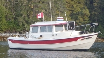
Ron on Meander
Joined: 17 Jun 2004
Posts: 561
City/Region: Powell River
State or Province: BC
C-Dory Year: 2005
C-Dory Model: 25 Cruiser
Vessel Name: Meander
Photos: Meander
|
 Posted: Fri Mar 18, 2016 8:10 pm Post subject: Posted: Fri Mar 18, 2016 8:10 pm Post subject: |
 |
|
| Quote: | | Yes, I am biased. I think we live in amazing place with lots of places to explore. |
Can't agree more I'm biased as well. I hope this link will work well enough to show folks the area we are biased about.
http://www.adsat.com/Desolation-Sound_p_35.html
Cheers
Ron |
|
| Back to top |
|
 |
cgypsy
Joined: 02 Mar 2015
Posts: 181
City/Region: Vancouver Island
State or Province: BC
C-Dory Year: 1999
C-Dory Model: 22 Cruiser
Vessel Name: C Gypsy
Photos: C Gypsy
|
| Posted: Fri Mar 18, 2016 8:48 pm Post subject: |
|
|
| Quote: | | I hope this link will work well enough to show folks the area we are biased about |
I grew up in Powell River hearing about all these interesting places on the coast that I had never been to, so a couple of years ago I decided it was time to go see them.
We had boats, but we mostly went lake boating on Haslam Lake (yes, they used to allow power boats on the watershed) and Powell Lake.
There are so many awesome places that people go past on their way to the "popular" places like Desolation Sound, but there are lots of other truly awesome places around the area too.
I spent some time in Desolation Sound last summer and it was awesome, but this summer I am going to check out some places that I haven't really been to yet.
Basically, I'm going to circumnavigate Texada Island and see how many side trips I make along the way.
_________________
Gypsy
Life is not about waiting for the storm to pass, it is about learning to dance in the rain.
 |
|
| Back to top |
|
|
hardee
Joined: 30 Oct 2006
Posts: 12632
City/Region: Sequim
State or Province: WA
C-Dory Year: 2005
C-Dory Model: 22 Cruiser
Vessel Name: Sleepy-C
Photos: SleepyC
|
| Posted: Sat Mar 19, 2016 12:50 am Post subject: |
|
|
| Island Explorer wrote: | | Quote: | | More photos in my Princess Louisa album here. |
You have me convinced. It should be great and if the weather is nice it will be like going to a completely different place.
I think the clouds and rain made it look really cool.
I think I may do an extended circle tour: Comox - Powell River - Jervis Inlet - Princess Louisa Inlet - Skookumchuck - Sechelt Penninsula - Skookumchuck - Nelson Island - Madeira Park - Jedidiah - Lasquiti - Tribune Bay (Hornby Island) - Comox
There are so many awesome places along that route and many of them get overlooked because people just hurry right past them.
This same route would work well if it started at French Creek (Parksville) and went to Jedidiah first, Powell River in the middle, and ended at Lasquiti. There is a really good boat launch at French Creek and you can get long term parking at the campsite nearby. You can also park right at the launch, but it is more money and the campsite is very close.
Sleepy C and anyone else who wants to go to all or part of this route is welcome to join me. I would love the company. |
[/quote]
Gotta learn this tablet thing. Can't cut and paste (yet).
I'm traveling now but will be home soon. I need to look up where all those are. I just remember tracing out a loop on my planning chart --> starting at Telegraph Covered getting to PRINCESS and up to PLI. So many places, so little time.
I. Gypsy thanks for the invite. Sounds fun. Have some studying to do now.
Harvey
SleepyC 
 
_________________
Though in our sleep we are not conscious of our activity or surroundings, we should not, in our wakefulness, be unconscious of our sleep. |
|
| Back to top |
|
|
cgypsy
Joined: 02 Mar 2015
Posts: 181
City/Region: Vancouver Island
State or Province: BC
C-Dory Year: 1999
C-Dory Model: 22 Cruiser
Vessel Name: C Gypsy
Photos: C Gypsy
|
| Posted: Sat Mar 19, 2016 1:56 am Post subject: |
|
|
| Quote: | | I need to look up where all those are |
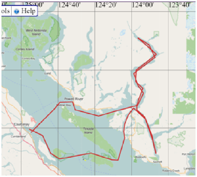
Here is a simplified map. The entire distance is almost 200 nm and it includes some pretty neat places. It would be shorter if you leave out Sechelt Inlet. |
|
| Back to top |
|
|
hardee
Joined: 30 Oct 2006
Posts: 12632
City/Region: Sequim
State or Province: WA
C-Dory Year: 2005
C-Dory Model: 22 Cruiser
Vessel Name: Sleepy-C
Photos: SleepyC
|
| Posted: Sat Mar 19, 2016 2:07 am Post subject: |
|
|
Island Explorer, Big thanks for that routing chart. Gives me a much better idea. My current plan, which is still in formulation stage would bring me down along the mainland side, past Lund. Then returning via Lund and depending on the weather, up Johnston or...???
Since much of my travel is at slow cruise, I tend to go with the current and tide to my advantage. Takes longer, but I see more.
Harvey
SleepyC
|
|
| Back to top |
|
|
bridma
Joined: 13 Sep 2011
Posts: 1155
City/Region: Comox
State or Province: BC
C-Dory Year: 2009
C-Dory Model: 22 Cruiser
Vessel Name: Nomad
Photos: Nomad
|
| Posted: Mon Mar 21, 2016 4:44 pm Post subject: |
|
|
Here is a question for you Harvey as I know you have a lot of time on your hands 
I never look at 'tides and currents' unless I am transiting rapids. I feel that in a C-Dory that draws just a few inches, I am skimming across the surface unlike a deeper v-hull. Any idea how much fuel and time you save by going with the current rather than against? I know it depends on how many knots the current is running at, but maybe you have a magic formula?
Martin. |
|
| Back to top |
|
|
cgypsy
Joined: 02 Mar 2015
Posts: 181
City/Region: Vancouver Island
State or Province: BC
C-Dory Year: 1999
C-Dory Model: 22 Cruiser
Vessel Name: C Gypsy
Photos: C Gypsy
|
| Posted: Mon Apr 04, 2016 12:14 am Post subject: |
|
|
Here is a link to information about Powell River http://powellriver.info/
 |
|
| Back to top |
|
|
hardee
Joined: 30 Oct 2006
Posts: 12632
City/Region: Sequim
State or Province: WA
C-Dory Year: 2005
C-Dory Model: 22 Cruiser
Vessel Name: Sleepy-C
Photos: SleepyC
|
| Posted: Mon Apr 04, 2016 2:07 pm Post subject: |
|
|
Thanks for posting that link, and photo. Looks like there is a ton of stuff to do around Powell River. I'm beginning to see what the draw is there. Also thinking that a good access might be from Pacific Playground, near Oyster River.
Harvey
SleepyC
 |
|
| Back to top |
|
|
bridma
Joined: 13 Sep 2011
Posts: 1155
City/Region: Comox
State or Province: BC
C-Dory Year: 2009
C-Dory Model: 22 Cruiser
Vessel Name: Nomad
Photos: Nomad
|
| Posted: Mon Apr 04, 2016 2:13 pm Post subject: |
|
|
Hi Harvey,
From Comox it is 55 mins to the north end of Texada Island, and then another 10/15 mins into Powell River. I have done it a ton of times, my daughter lives in Powell River.
I'm not a speed demon either. When I'm up on plane, it's usually 13/14 knots.
Martin. |
|
| Back to top |
|
|
hardee
Joined: 30 Oct 2006
Posts: 12632
City/Region: Sequim
State or Province: WA
C-Dory Year: 2005
C-Dory Model: 22 Cruiser
Vessel Name: Sleepy-C
Photos: SleepyC
|
| Posted: Mon Apr 04, 2016 2:23 pm Post subject: |
|
|
Thanks Martin,
I'm still working on putting this together. I had originally planned on Launching at Telegraph Cove and going down from there, and then returning there via a different route for variety.
Harvey
SleepyC
|
|
| Back to top |
|
|
cgypsy
Joined: 02 Mar 2015
Posts: 181
City/Region: Vancouver Island
State or Province: BC
C-Dory Year: 1999
C-Dory Model: 22 Cruiser
Vessel Name: C Gypsy
Photos: C Gypsy
|
| Posted: Wed Apr 27, 2016 12:45 am Post subject: |
|
|
From BC Ferries:
Save 50% per additional foot on extra length passenger vehicles.
Travel all summer long with up to 80 sailings a week and save $3.25 per additional foot on extra length passenger vehicles.
Refer to this detailed promotional sailing schedule and take advantage of these savings.
When June 1 to September 30, 2016
Select Sailings (See schedule for details)
Where Metro Vancouver Victoria (Tsawwassen - Swartz Bay)
Metro Vancouver Nanaimo (Tsawwassen - Duke Point)
For More Information
http://www.bcferries.com/promotions/2016-xft-details.html
When you save big on your extra length vehicle, it means more opportunities to get out and explore BC's west coast. There's no better time to plan your summer getaway! Reservations are strongly recommended. |
|
| Back to top |
|
|
hardee
Joined: 30 Oct 2006
Posts: 12632
City/Region: Sequim
State or Province: WA
C-Dory Year: 2005
C-Dory Model: 22 Cruiser
Vessel Name: Sleepy-C
Photos: SleepyC
|
| Posted: Wed Apr 27, 2016 2:01 am Post subject: |
|
|
| bridma wrote: | Here is a question for you Harvey as I know you have a lot of time on your hands
I never look at 'tides and currents' unless I am transiting rapids. I feel that in a C-Dory that draws just a few inches, I am skimming across the surface unlike a deeper v-hull. Any idea how much fuel and time you save by going with the current rather than against? I know it depends on how many knots the current is running at, but maybe you have a magic formula?
Martin. |
Martin, Sorry for the delay in response.
I don't have any hard numbers, but as an example, this is from frequent routing that I use.
Crossing from Sequim Bay to Friday Harbor. Rapid cruise, direct route, about 35 miles and a fuel fill at Friday Harbor. The usual fill is about 15 gal after a cruise of about 3.5 hours, cruise speed about 12 - 14 knots. On a slow cruise, speed about 5.5 water speed (not over the ground speed), running with the tidal currents - mostly - going around Lopez Island to the East, making the distance to Friday Harbor about 55 miles. Time elapsed was about 6.5 hours. So, farther distance and longer time, but following the currents shown in the Washburn's Currents book, with the currents running from 4.5 knots down to zero, maybe with an average of 2.5 - 3 knots help my over the ground speeds were running about 8 knots. The fuel purchase was about 10 gal. For me it equals more boating time, more scenery, more time on the water for fewer $$ paid at the pump.
These numbers are from memory, and I run across to FH frequently. I have gone the around about route only twice. The currents in Juan de Fuca do not just run in and out, but there are swirls and rivers, based on the bottom contours so it is an exercise in plotting to follow the Washburns.
Typically, I think the slow cruise, (and I prefer the speed where there is no bow curl wave,) uses about 1/3rd less fuel. I like that because it is quiet and I have more time to watch for the wildlife.
Hope that helps.
Harvey
SleepyC
 |
|
| Back to top |
|
|
bridma
Joined: 13 Sep 2011
Posts: 1155
City/Region: Comox
State or Province: BC
C-Dory Year: 2009
C-Dory Model: 22 Cruiser
Vessel Name: Nomad
Photos: Nomad
|
| Posted: Wed Apr 27, 2016 4:25 pm Post subject: |
|
|
Thanks Harvey for putting that info together, it is an interesting read. Just taking average numbers and conditions, a 'rule of thumb' guide that I will use is, that by going at below planing speed, my fuel consumption is cut by 30% if I go with the currents rather than against. Looking forward to catching up with you again at Friday Harbor and Powell River gatherings.
I know you can smell a fish & chip shop at 5 miles, let me know what you find
Martin. |
|
| Back to top |
|
|
hardee
Joined: 30 Oct 2006
Posts: 12632
City/Region: Sequim
State or Province: WA
C-Dory Year: 2005
C-Dory Model: 22 Cruiser
Vessel Name: Sleepy-C
Photos: SleepyC
|
| Posted: Thu Apr 28, 2016 4:31 pm Post subject: |
|
|
| bridma wrote: | Thanks Harvey for putting that info together, it is an interesting read. Just taking average numbers and conditions, a 'rule of thumb' guide that I will use is, that by going at below planing speed, my fuel consumption is cut by 30% if I go with the currents rather than against. Looking forward to catching up with you again at Friday Harbor and Powell River gatherings.
I know you can smell a fish & chip shop at 5 miles, let me know what you find
Martin. |
Hi Martin,
Yes, I think the 30% is a good number. And it gets way more than 30% increase in pleasure. Single handing it also gives me more time to look ahead and then take a picture or something without my hands on the wheel for a few seconds.
As to the F&C. I just might make it to Fish on Fifth before Friday Harbor. I'm doing a Kayak support trip so will be somewhere in the islands before that Thursday. Maybe meet up with some Canadian boats headed to the San Juans.
Harvey
SleepyC
 |
|
| Back to top |
|
|
bridma
Joined: 13 Sep 2011
Posts: 1155
City/Region: Comox
State or Province: BC
C-Dory Year: 2009
C-Dory Model: 22 Cruiser
Vessel Name: Nomad
Photos: Nomad
|
| Posted: Thu Apr 28, 2016 5:39 pm Post subject: |
|
|
Hi Harvey,
We will be in the Gulf Islands on that Thursday. We'll talk again closer to the time. Do you receive these messages when you are out on the boat?
Martin. |
|
| Back to top |
|
|
|
 Search
 Private Messages
 Profile
 Log in
 Register
 Help
Help
