| View previous topic :: View next topic |
| Author |
Message |
pat.jack
Joined: 01 Aug 2011
Posts: 99
City/Region: Rochester
State or Province: NY
C-Dory Year: 2003
C-Dory Model: 22 Cruiser
Vessel Name: C-renity
Photos: C-renity
|
 Posted: Tue May 06, 2014 3:56 pm Post subject: Posted: Tue May 06, 2014 3:56 pm Post subject: |
 |
|
I just caught the messages on True North vs Magnetic. I find it of interest since my wife Pat and I have just recently finished taking a USPS Piloting class to improve our understanding of navigation. We consider ourselves novices , and we were looking to better understand how to use the GPS unit that came with our boat. The course focused on paper charts-and manual plotting. As you have already mentioned, the classes focused on plotting in magnetic, to simplify the quick reference to the boats magnetic compass. The reference in the class is to variation and deviation to compensate the boat's compass. Now that I think of it, I will probably reference my GPS to magnetic. It's interesting to read that most folks use paper as a reference, and don't routinely plot by hand. I'm guessing more sailors would still do the manual plotting then power boaters. Our course instructor is a sailor, and he does his manual plotting on paper. As was mentioned-going slow and having time to watch the compass and transfer to paper probably means you're on a sail boat!
We will finally be taking our boat out of winter storage next week-and getting it in the water! (the great lakes are finally ice free-our boat is stored on Sodus Bay on Lake Ontario). We will probably spend most of our time cruising the Erie Canal this summer. Pretty hard to get lost in there-we can still just about read street signs!!
Jack Howell |
|
| Back to top |
|
 |
Two Bears
Joined: 07 Nov 2009
Posts: 296
City/Region: Orofino
State or Province: ID
C-Dory Year: 2006
C-Dory Model: 22 Cruiser
Vessel Name: Two Bears
Photos: Two Bears
|
| Posted: Tue May 06, 2014 8:44 pm Post subject: |
|
|
It might be helpful to add a discussion of history, which can be summarized as engineers/ map makers on land used true north and sailors at sea & pilots in the air used magnetic north (because they had to navigate with a compass, no time to take a solar shot to determine true north). The chart makers for each of those fields followed those guides. All was well until the digital age and now we are in the middle of a mess.
The bottom line is we each need to know what our charts are telling us, which the discussions before mine have demonstrated. An example of how the digital age is throwing us curve balls is how do you designate your location. There are three ways and different GPS units will give one or more of these locations: 1) Degrees & decimal of degree - ie 49.118N; 2) Degree, minute & decimal of minute, ie 49N 10.1 min; and 3) Degrees, minutes and seconds, ie 49N 10' 10". Back in the dark ages (1950s& 60s) I was taught the 3rd one, but today it is seldom used. The last two locations will be not far apart, but the first one can be quite different from the other two locations.
If the world was just now starting to make and use maps & charts I'm sure we would all use true north. However, it will be quite a while before things settle down, become standarized and we can have some level of confidence about what a new (to us) map or chart plotter is telling us.
Chuck
_________________
Chuck & Penny Raddon
Orofino, Idaho |
|
| Back to top |
|
|
thataway
Joined: 02 Nov 2003
Posts: 21469
City/Region: Pensacola
State or Province: FL
C-Dory Year: 2007
C-Dory Model: 25 Cruiser
Vessel Name: thataway
Photos: Thataway
|
| Posted: Tue May 06, 2014 11:59 pm Post subject: |
|
|
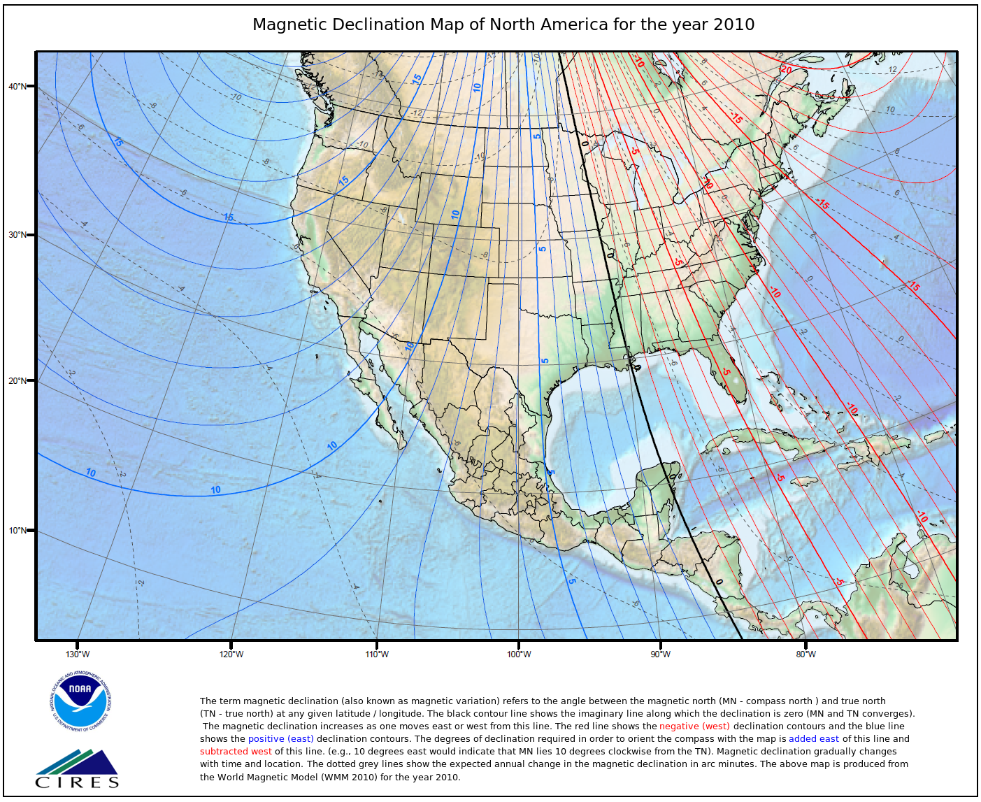
I cannot remember picking up a chart or map which magnetic North was pointing to the top of the map or chart (granting that Grid North may vary +/- 2 degrees E/W within a time zone)--except in that line which currently approximately runs thru New Orleans, LA to Grand Rapids, MN.
 Normally a map or chart will have true north or grid north as the orientation. Normally a map or chart will have true north or grid north as the orientation.
In 2010 New Orleans was 0° 0' 22" E changing by 7.3' W per year, and now is 0° 28' 53" W changing by 7.3' W per year, so almost half a degree in 4 years
The point is, unless you adjust that compass for each year, you will be off--and it may be significant in a trip over any distance. True always remains the same--Lat and Long, basically remain the same--Bill can chime in here about continental plate drifts. When you pick up a chart, (if you use one) do you know what year base the variation was taken for--and then calculate the change to the current date? Also the datum and map projection have to be taken into account when you use two different media--paper chart and GPS chart plotter. They may not be the same for the two media.
A question I cannot answer is does the magnetic reading conversion on the GPS take the yearly change in variation into effect to the specific date that you are navigating, or is the variation updated when you put in the latest chart upgrade?
Let me add if I was backpacking or hiking across country, or even on a trail system, I would be using the compass along with the hand held GPS, even though I do not use it as often in the boat as I once did. The car--all GPS now.
_________________
Bob Austin
Thataway
Thataway (Ex Seaweed) 2007 25 C Dory May 2018 to Oct. 2021
Thisaway 2006 22' CDory November 2011 to May 2018
Caracal 18 140 Suzuki 2007 to present
Thataway TomCat 255 150 Suzukis June 2006 thru August 2011
C Pelican; 1992, 22 Cruiser, 2002 thru 2006
Frequent Sea; 2003 C D 25, 2007 thru 2009
KA6PKB
Home port: Pensacola FL |
|
| Back to top |
|
|
rogerbum
Joined: 21 Nov 2004
Posts: 5928
City/Region: Kenmore
State or Province: WA
C-Dory Year: 2008
C-Dory Model: 255 Tomcat
Vessel Name: Meant to be
Photos: SeaDNA
|
| Posted: Wed May 07, 2014 12:16 am Post subject: |
|
|
For me, it doesn't matter one iota. I have multiple GPS systems (several with their own batteries) and all that matters is where I'm pointed at and where I am relative to the map on the GPS's. I haven't needed nor missed a compass on the boat in 10+ years of boating.
_________________
Roger on Meant to be |
|
| Back to top |
|
|
Aurelia
Joined: 21 Aug 2009
Posts: 2335
City/Region: Gig Harbor
State or Province: WA
Photos: Aurelia
|
| Posted: Wed May 07, 2014 12:28 am Post subject: |
|
|
Here is the basics on the topic and Bob's question from Garmin. I believe they are also generally following a flight based rule of +/-2 degrees of allowed variance on the variation estimate. The details of each companies unit inner workings is often at least a little fuzzy. I have contacts that have cleared things up for me when needed but sometimes the answer is more complicated than a client wants to hear.
I still like a compass but I don't refer to it much although I do like using it to maintain a heading better than the GPS screen if visibility is very poor. I find that I tend to steer straighter with that simple reference than the GPS reference for some reason.
Greg
_________________
Greg, Cindie & Aven
Gig Harbor
Aurelia - 25 Cruiser sold 2012
Ari - 19 Cruiser sold 2023
currently exploring with "Lia", 17 ft Bullfrog Supersport Pilothouse |
|
| Back to top |
|
|
journey on
Joined: 03 Mar 2005
Posts: 3599
City/Region: Valley Centre
State or Province: CA
C-Dory Year: 2005
C-Dory Model: 25 Cruiser
Vessel Name: journey on
Photos: Journey On
|
| Posted: Wed May 07, 2014 12:56 am Post subject: |
|
|
It's interesting to think about how things evolve, if I may use that e word. True North and Magnetic North have both been used for a long time and in general both served their purpose.
The original North direction was the north star, Polaris, before magnetic compasses. And of course, the North Star gives true north, as well as the time of day as Ursa Minor rotate around Polaris. And Portolans/charts were drawn in True North, if any geographical reference is used since that's all that was known.
So around the 12 century, the Italians started using the compass. Yes the Chinese knew it for centuries before, but apparently it was discovered in the West in Amalfi/Italy, and thence to the Arabs, since the Arabic word for compass refers to the Italians. So now navigators noticed that the compass didn't point at Polaris. Since the compass was always at hand, charts started using Magnetic, but were still plotted in True North.
Charts were still drawn to True North, because that's the way the Earth is. The French did a very complete job of determining the correct orientation of Europe with respect to the rotating axis of the globe not to the compass reference. Though of course the chart makers understood how the compass pointed and gave us charts such as the one Bob has shown above, indicating magnetic variation worldwide.
This carried on down until inertial navigation was developed during and about WWII. Since one needs to account for the rotation of the Earth in the inertial equations, True North was required. And the Gyro Compass gave True North. And now we have ships and planes navigating using Inertial Navigation, and each one also had a magnetic compass for backup. And you can bet your fanny that both systems were well understood.
Now in the last 1/2 century, Loran and then GPS come along and gives absolute geographic position, a great advance, and thus inherently gives the velocity and destination vectors in True North, with the option of Magnetic North if that's what you want. And that's still well understood, even though there certainly have been some screwups.
Each group of navigators selects the North reference that's correct for them. If you're launching rockets, True North it is. If you're piloting a sailboat around Narragansett Bay, you'd probably use Magnetic. And navigators truly understand this.
So to say everything is a mess simply isn't true. It's not that complicated once you understand what's going on and you'd better understand the reference frame (True or Magnetic,) that you're using, but it's not a mess. It may be a little hard to understand when first introduced (TVMDC, anybody?) but it's well understood.
I mention that the original question is "do you prefer True or Magnetic?" And one has to understand both references to honestly have a choice. BTW, I don't care, just tell me which it is.
Boris |
|
| Back to top |
|
|
hardee
Joined: 30 Oct 2006
Posts: 12637
City/Region: Sequim
State or Province: WA
C-Dory Year: 2005
C-Dory Model: 22 Cruiser
Vessel Name: Sleepy-C
Photos: SleepyC
|
| Posted: Wed May 07, 2014 1:39 am Post subject: |
|
|
This is really interesting. I think I am liking True more and more. Looks like it might be less hassle over the long run. Less change, less variance and Less calculating.
You all are a really "straight up bunch"  
Harvey
SleepyC 
_________________
Though in our sleep we are not conscious of our activity or surroundings, we should not, in our wakefulness, be unconscious of our sleep. |
|
| Back to top |
|
|
Aurelia
Joined: 21 Aug 2009
Posts: 2335
City/Region: Gig Harbor
State or Province: WA
Photos: Aurelia
|
| Posted: Wed May 07, 2014 9:43 am Post subject: |
|
|
Harvey, When you say...Less change, less variance and Less calculating
You are actually talking about Magnetic north. That is the simpler navigational reference that does not require any local or regional adjustment.
The "adjustment" to magnetic referred to above relates to you choosing a setting on a device that defaults to true such as GPS and the "adjustment" is you picking a setting. Don't worry about the default, just make a choice. Do you want to think about whether your compass and devices are all agreeing on the true north declination offset or do you want to just set everything to Mag and forget about it? Do you plot courses on paper maps? If yes, then you need to find the declination offset on the map and set any devices of compasses that you are using to match it and confirm that again with each physical map you use. That task is not hard once you are familiar with adjusting your devices but it is just one more thing to manage.
Magnetic is how a compass points with no intervention by the user to do any correction for anything (with correct installation). That is the least work or trouble and requires no calculations.
True = Magnetic, plus or minus the declination which changes over time and by location as you travel. |
|
| Back to top |
|
|
colobear
Joined: 23 Jan 2005
Posts: 2154
City/Region: Denver
State or Province: CO
C-Dory Year: 2006
C-Dory Model: 22 Cruiser
Photos: C-Cakes
|
| Posted: Wed May 07, 2014 11:35 am Post subject: |
|
|
Boy does this thread illustrate the knowledge and helpfulness available on this site...and with not an iota of snarkiness. What pleasant thing. Once again thanks to Bill and Mike for the site and for the members thereon....and for the basic rule!!
_________________
Patti and Barry
formerly C-Cakes, now
rving around N. America |
|
| Back to top |
|
|
journey on
Joined: 03 Mar 2005
Posts: 3599
City/Region: Valley Centre
State or Province: CA
C-Dory Year: 2005
C-Dory Model: 25 Cruiser
Vessel Name: journey on
Photos: Journey On
|
| Posted: Wed May 07, 2014 12:04 pm Post subject: |
|
|
Aurelia,
Please check your definitions. I believe you might have them backwards.
True is the way the Earth is. All True North directions lead to the North Pole, defining the axis around which the Earth spins. It has been a constant for the life of the Earth.
Magnetic is the way the compass points. As shown in Bob/thataway's map above, the compass points in different directions at different points on the Earth. And even worse, that varying direction changes with time.
Nothing wrong with choosing Magnetic as the heading, but one has to make sure you're using the correct corrections: difference between True and Magnetic and any errors inherent in the compass itself.
The charts of the Earth are laid out to represent the actual geographic relationship, the truth, from whence the appellation "True" is derived. So, when you're going from one place to another, you are using the True course. Magnetic is just using a compass to measure an approximation of True.
The compass was and is a big step forward, but it's a measurement instrument, and doesn't change the way the Earth is. The same may be said for GPS, but it has better accuracy.
Boris |
|
| Back to top |
|
|
Aurelia
Joined: 21 Aug 2009
Posts: 2335
City/Region: Gig Harbor
State or Province: WA
Photos: Aurelia
|
| Posted: Wed May 07, 2014 12:24 pm Post subject: |
|
|
We are on the same page Boris. That is part of the trick with north references, they are confusing and the mixture of terms being tossed around makes it hard to keep them straight. I am a GIS professional and instructor by trade and address related questions on a regular basis.
I am a map person and regional GPS specialist so True has its place for me. But when managing a blend of humans, devices, and communication between them all, I recommend magnetic to most folks.
Greg |
|
| Back to top |
|
|
rogerbum
Joined: 21 Nov 2004
Posts: 5928
City/Region: Kenmore
State or Province: WA
C-Dory Year: 2008
C-Dory Model: 255 Tomcat
Vessel Name: Meant to be
Photos: SeaDNA
|
| Posted: Wed May 07, 2014 1:06 pm Post subject: |
|
|
I just use my GPS's and keep the boat in the blue part and going in the direction I want to go. If'n for some reason my eye or radar differs from what the GPS says, I'm going to place more faith in my eye and/or radar. 
For all practical purposes, most times I don't even really need to know what direction N is except for the brief periods of time when I transition from not moving/moving slower than the current to moving. E.g. it's useful to know what direction to point the boat until the gps indication of direction is accurate. After that, I just keep it in the blue and pointing where I want to go. This is a fun and interesting discussion, but I would claim true vs magnetic is of little import when it comes to how most of us use the GPS in practice. |
|
| Back to top |
|
|
Aurelia
Joined: 21 Aug 2009
Posts: 2335
City/Region: Gig Harbor
State or Province: WA
Photos: Aurelia
|
| Posted: Wed May 07, 2014 1:19 pm Post subject: |
|
|
Right you are Roger. A more important factor might be how you set the safety depth on your chartplotter map display to make sure when you see blue, it really should be blue enough for your boat.
Greg |
|
| Back to top |
|
|
BrentB
Joined: 15 Jul 2006
Posts: 4420
City/Region: Greenwood
State or Province: IN
Photos: BrentB
|
| Posted: Wed May 07, 2014 2:48 pm Post subject: |
|
|
thanks all
very informative
Q. What do John Wayne and a map key have in common?
A. Both are legends.
_________________
Brent Barrett |
|
| Back to top |
|
|
Jazzmanic
Joined: 07 Feb 2005
Posts: 2232
City/Region: Seattle
State or Province: WA
Photos: C-Dancer
|
| Posted: Wed May 07, 2014 3:39 pm Post subject: |
|
|
| rogerbum wrote: | I just use my GPS's and keep the boat in the blue part and going in the direction I want to go. If'n for some reason my eye or radar differs from what the GPS says, I'm going to place more faith in my eye and/or radar.
For all practical purposes, most times I don't even really need to know what direction N is except for the brief periods of time when I transition from not moving/moving slower than the current to moving. E.g. it's useful to know what direction to point the boat until the gps indication of direction is accurate. After that, I just keep it in the blue and pointing where I want to go. This is a fun and interesting discussion, but I would claim true vs magnetic is of little import when it comes to how most of us use the GPS in practice. |
+1
My thoughts exactly Roger. But still, a truly informative discussion. 
Peter |
|
| Back to top |
|
|
|
|
You cannot post new topics in this forum
You cannot reply to topics in this forum
You cannot edit your posts in this forum
You cannot delete your posts in this forum
You cannot vote in polls in this forum
You cannot attach files in this forum
You cannot download files in this forum
|
|
 Search
 Private Messages
 Profile
 Log in
 Register
 Help
Help
