| View previous topic :: View next topic |
| Author |
Message |
Grazer
Joined: 16 Dec 2011
Posts: 183
City/Region: Yukon
State or Province: YT
C-Dory Year: 2004
C-Dory Model: 22 Cruiser
Vessel Name: C-Horse
Photos: Grazer
|
 Posted: Sun Dec 16, 2012 2:41 pm Post subject: Posted: Sun Dec 16, 2012 2:41 pm Post subject: |
 |
|
Hello Brats,
I was just wondering about my BlueChart America's CD-Rom that seems to be unusable now that Garmin has discontinued unlocking maps from the older version software. Does anyone know of a solution around this? I don't want to have to purchase another set of digital charts to use on my older GPS unit despite the upgrades. After all they are based on the same nautical charts as before.
Grazer |
|
| Back to top |
|
 |
Sunbeam
Joined: 23 Feb 2012
Posts: 3990
City/Region: Out 'n' About
State or Province: Other
C-Dory Year: 2002
C-Dory Model: 22 Cruiser
Photos: Sunbeam
|
| Posted: Sun Dec 16, 2012 4:32 pm Post subject: |
|
|
| Grazer wrote: | Hello Brats,
I was just wondering about my BlueChart America's CD-Rom that seems to be unusable now that Garmin has discontinued unlocking maps from the older version software. Does anyone know of a solution around this? |
Does your unit use the "Bluechart datacards" that look like this?

If so, that's the same ones mine uses. I have found (as it sounds like you have) that they are not available to buy new anymore. What I have found for options:
1) Buy used (eBay, Craigslist, etc.), either pre-made cards or blank ones.
2) Ask someone who has the CD of an area and a datacard programmer, to make you a datacard (you have to supply a blank card, see #1).
I tried to get a card loan/exchange going, but there didn't seem to be a lot of interest. Maybe most people have either moved on to a newer unit, or they just already have cards for the areas they cruise?
Sunbeam 
PS: I have recently purchased a used datacard programmer, because I'm having a problem with my Garmin where it loses the signal momentarily/repeatedly. Garmin apparently made some updates to the antenna software that helped or fixed this problem, and those updates are available for free on Garmin's site, but - of course there is a catch! - you have to have a way to get them onto a datacard. Hence the datacard programmer to find out if the updated antenna software will help. |
|
| Back to top |
|
|
Grazer
Joined: 16 Dec 2011
Posts: 183
City/Region: Yukon
State or Province: YT
C-Dory Year: 2004
C-Dory Model: 22 Cruiser
Vessel Name: C-Horse
Photos: Grazer
|
| Posted: Mon Dec 17, 2012 12:54 am Post subject: |
|
|
Sunbeam,
No datacards. I have the original MapSource Cd Rom. The problem is that I got a new computer, went to install the maps and software only to find out that Garmin.com no longer unlocks the maps. They have discontinued this service as they no longer support this older BlueChart version. I'm wondering if there is some sort of "hack" available to unlock the charts or is this CD Rom nothing more than an emergency signalling device now. |
|
| Back to top |
|
|
Mike-CD22
Joined: 30 Oct 2011
Posts: 24
City/Region: Manassas
State or Province: VA
C-Dory Year: 2004
C-Dory Model: 22 Cruiser
Vessel Name: Brook C
Photos: Mike-CD22
|
| Posted: Mon Dec 17, 2012 7:38 am Post subject: |
|
|
Grazer,
I had the exact same problem you describe. I ended up calling Garmin and just explained that I had a MapSource CD and could not get the maps unlocked to update my unit. The person was really helpful and gave me an unlock code right there and helped me install it and unlock the maps. Works great now. |
|
| Back to top |
|
|
Captains Cat
Joined: 03 Nov 2003
Posts: 7313
City/Region: Cod Creek>Potomac River>Chesapeake Bay
State or Province: VA
C-Dory Year: 2005
C-Dory Model: 22 Cruiser
Vessel Name: Captain's Choice II
Photos: Captain's Cat
|
| Posted: Mon Dec 17, 2012 10:01 am Post subject: Garmin |
|
|
I've got their lifetime updater on one of my laptops, don't remember what it cost, if anything, but if you have it and register your devices, it will download the updates to any Garmin device and push them to your device through a USB connection. On some Garmin units, like my handheld 76CSX plotter, there is a mini USB connection hidden in the battery compartment. On one of my car units, it pushes it through the power cord.
Or am I not understanding the problem correctly! 
_________________
CHARLIE and PENNY CBRAT #100
Captain's Cat II 2005 22 Cruiser
Thataway (2006 TC255 - Sold Aug 2013)
Captain's Cat (2006 TC255 - Sold January 2012)
Captain's Kitten (1995 CD 16 Angler- Sold June 2010)
Captain's Choice (1994 CD 22 Cruiser- Sold Jun 2007)
Potomac River/Chesapeake Bay
K4KBA |
|
| Back to top |
|
|
Sunbeam
Joined: 23 Feb 2012
Posts: 3990
City/Region: Out 'n' About
State or Province: Other
C-Dory Year: 2002
C-Dory Model: 22 Cruiser
Photos: Sunbeam
|
| Posted: Mon Dec 17, 2012 10:29 am Post subject: |
|
|
| Grazer wrote: | Sunbeam,
No datacards. I have the original MapSource Cd Rom. The problem is that I got a new computer, went to install the maps and software only to find out that Garmin.com no longer unlocks the maps. |
Ah, gotcha. Well it sounds like that CD is a good thing to have! And like Garmin may help you out.
Sunbeam |
|
| Back to top |
|
|
Grazer
Joined: 16 Dec 2011
Posts: 183
City/Region: Yukon
State or Province: YT
C-Dory Year: 2004
C-Dory Model: 22 Cruiser
Vessel Name: C-Horse
Photos: Grazer
|
| Posted: Mon Dec 17, 2012 1:27 pm Post subject: |
|
|
| Thanks MikeCD22. I'll try calling Garmin. Do recall when that was? |
|
| Back to top |
|
|
Mike-CD22
Joined: 30 Oct 2011
Posts: 24
City/Region: Manassas
State or Province: VA
C-Dory Year: 2004
C-Dory Model: 22 Cruiser
Vessel Name: Brook C
Photos: Mike-CD22
|
| Posted: Mon Dec 17, 2012 2:32 pm Post subject: |
|
|
| This happened to me just this Summer. Same thing, new computer, trying to update my 276C. Program wouldn't let me unlock with my code. Navigated around the phone system (don't remember exactly how) and I waited on the phone with the speaker on until someone picked up. They were extremely good about it and understanding. They know about this type of problem with existing customers with older programs. They also saw that my unit was on my account page on their site. |
|
| Back to top |
|
|
Aurelia
Joined: 21 Aug 2009
Posts: 2331
City/Region: Gig Harbor
State or Province: WA
Photos: Aurelia
|
|
| Back to top |
|
|
Aurelia
Joined: 21 Aug 2009
Posts: 2331
City/Region: Gig Harbor
State or Province: WA
Photos: Aurelia
|
|
| Back to top |
|
|
Aurelia
Joined: 21 Aug 2009
Posts: 2331
City/Region: Gig Harbor
State or Province: WA
Photos: Aurelia
|
| Posted: Thu Jan 23, 2014 6:16 pm Post subject: |
|
|
Another round...
Sample updates:
Added support for GMR18/24xHD Radomes.
Added support for GXM52 weather antenna.
Improve units consistency between bridge height and bridge horizontal clearance.
Improved support for LakeVu HD cartography.
Addressed some potential instabilities when calculating Autoguidance routes.
Fixed issues with water speed calibration when using a GSD24/26.
Other performance improvements and bug fixes.
Chartplotters
http://www8.garmin.com/support/download_details.jsp?id=4763
Networked units
http://www8.garmin.com/support/download_details.jsp?id=4749 |
|
| Back to top |
|
|
Aurelia
Joined: 21 Aug 2009
Posts: 2331
City/Region: Gig Harbor
State or Province: WA
Photos: Aurelia
|
|
| Back to top |
|
|
Aurelia
Joined: 21 Aug 2009
Posts: 2331
City/Region: Gig Harbor
State or Province: WA
Photos: Aurelia
|
| Posted: Wed Jun 11, 2014 11:54 am Post subject: |
|
|
Another set of updates. If you have a piece of equipment below, you have an update opportunity.
Chartplotters
Changes made from version 2014.0421 to 2014.0605:
◦GMR18 xHD/GMR24 xHD: 2.30
◦GNX 20/GNX 21: 2.10
◦GCV 10: 2.10
MFDs
Changes made from version 2014.0421 to 2014.0605:
◦GPSMAP 8008/8012/8015/8208/8212/8215/8500/8530: 4.30
◦GNX 20/GNX 21: 2.10
◦GMR18 xHD/GMR24 xHD: 2.30
◦Garmin Card Reader: 3.50
◦GRID: 3.40
◦GCV 10: 2.10 |
|
| Back to top |
|
|
Aurelia
Joined: 21 Aug 2009
Posts: 2331
City/Region: Gig Harbor
State or Province: WA
Photos: Aurelia
|
| Posted: Wed Jul 02, 2014 12:31 am Post subject: |
|
|
Garmin just released an update to their newer units that adds enough features that I am cancelling my order for an older unit and I will just get the 741xs. The support for multiple android devices seals the deal for us as it will save me from adding another fishfinder to the cockpit for Cindie. The support previously for Apple devices did not float our boat one bit. We use them for work every day and they are not our cup of tea.
GPSMAP 741/741xs software version 3.60
as of June 26, 2014
Changes made from version 3.50 to 3.60:
Added support for sharing internal sonar across the Garmin Marine Network.
Added ability to select the sonar source for traditional sonar, DownVü, and SideVü if multiple sources are available.
Added support for synchronized scroll rates between traditional sonar, DownVü, and SideVü. Includes improvements to scroll rates and new and improved Auto scroll rate.
Added customization options for sonar data overlays.
Added the ability to hide individual data fields on overlays.
Added support for Garmin Helm on Android devices. Note: This requires version 1.20 of the Garmin Helm app for compatibility.
Added support for NMEA2000 and NMEA0183 GPS sensors.
Improved sailing (wind) gauge page.
Added support for hiding the menu bar while on full screen functions.
Improved the user experience for marking waypoints on paused sonar.
Fixed a shutdown when powering off device while adjusting media volume.
Fixed an issue where water speed wheels wouldn't function with DownVü transducers.
Fixed a shutdown on the engine page when the system language is Russian.
Fixed an issue with tides and currents dates being incorrect.
Other performance improvements and bug fixes.
http://garmin.blogs.com/my_weblog/2014/07/olathe-kanjuly-1-2014business-wire-garmin-international-inc-a-unit-of-garmin-ltd-nasdaq-grmn-the-global-leader.html#.U7OIMvlSb_8 |
|
| Back to top |
|
|
breausaw
Joined: 18 Jan 2006
Posts: 1222
City/Region: Anchorage
State or Province: AK
C-Dory Year: 2007
C-Dory Model: 25 Cruiser
Vessel Name: Triple J
Photos: Triple J
|
| Posted: Wed Jul 02, 2014 12:50 pm Post subject: |
|
|
| Aurelia wrote: | Garmin just released an update to their newer units that adds enough features that I am cancelling my order for an older unit and I will just get the 741xs. The support for multiple android devices seals the deal for us as it will save me from adding another fishfinder to the cockpit for Cindie. The support previously for Apple devices did not float our boat one bit. We use them for work every day and they are not our cup of tea.
GPSMAP 741/741xs software version 3.60
as of June 26, 2014
Changes made from version 3.50 to 3.60:
Added support for sharing internal sonar across the Garmin Marine Network.
Added ability to select the sonar source for traditional sonar, DownVü, and SideVü if multiple sources are available.
Added support for synchronized scroll rates between traditional sonar, DownVü, and SideVü. Includes improvements to scroll rates and new and improved Auto scroll rate.
Added customization options for sonar data overlays.
Added the ability to hide individual data fields on overlays.
Added support for Garmin Helm on Android devices. Note: This requires version 1.20 of the Garmin Helm app for compatibility.
Added support for NMEA2000 and NMEA0183 GPS sensors.
Improved sailing (wind) gauge page.
Added support for hiding the menu bar while on full screen functions.
Improved the user experience for marking waypoints on paused sonar.
Fixed a shutdown when powering off device while adjusting media volume.
Fixed an issue where water speed wheels wouldn't function with DownVü transducers.
Fixed a shutdown on the engine page when the system language is Russian.
Fixed an issue with tides and currents dates being incorrect.
Other performance improvements and bug fixes.
http://garmin.blogs.com/my_weblog/2014/07/olathe-kanjuly-1-2014business-wire-garmin-international-inc-a-unit-of-garmin-ltd-nasdaq-grmn-the-global-leader.html#.U7OIMvlSb_8 |
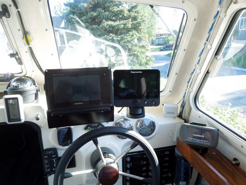
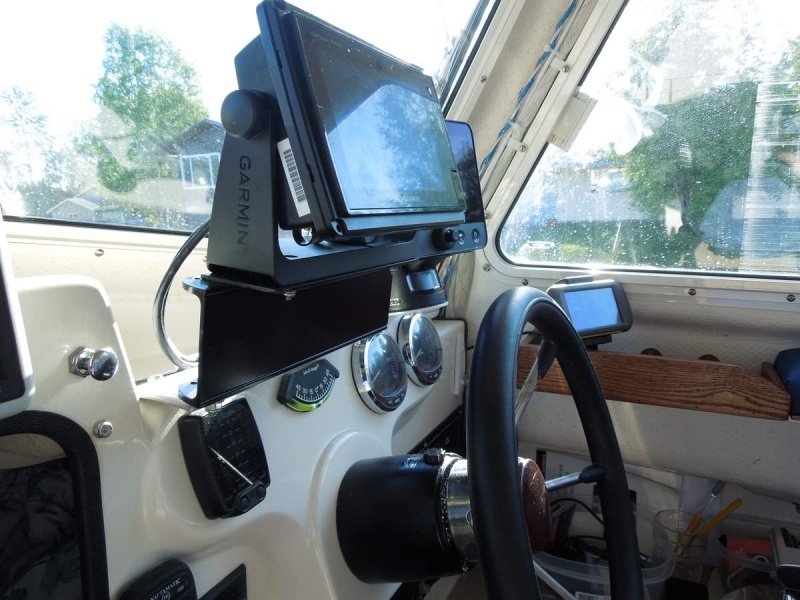
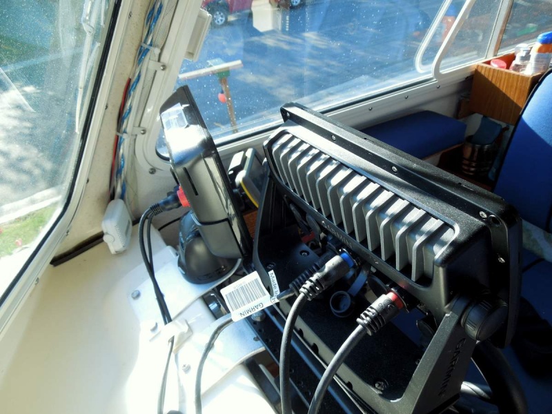
I recently updated my electronics to include the Garmin 741 xs and Raymarine Dragonfly 7.
Moved these units as far forward as possible with the Gamin centered mostly over the steering wheel. Using an Armar TM258 1KW with the Garmin, a hand-me-down from the former Raymarine E80 I replaced.
The GPS receiver on the Gamin is really robust, there is like zero lag time. On the other hand the GPS receiver on the Dragonfly is weak but only have this unit for its sonar and to use as a backup GPS, but then I have my Montana hand held nestled nearby.
Still fine tuning things but so far really like this setup. I generally only use the Dragonfly when fishing and the Garmin for navigation, with the 1kw transducer Im usually able to maintain bottom at cruise down to around 400 to 500 feet.
Granted the 741 is a bit small but pulled in close at fingertip length make a world of difference.
More than anything it was nice getting rid of that bulky E80. Even though I have these units pulled forward my visibility is way better.
Heading out today with my son for 3 or 4 days of fishing in the gulf outside PWS, hope to limit out on Halibut, Lings and Kings with a few rock fish tossed in.
_________________
Jay
2007 22ft C-Dory Triple J 2007-2012
2007 25ft C-Dory Triple J 2012-2018
Boatless for now but looking |
|
| Back to top |
|
|
|
 Search
 Private Messages
 Profile
 Log in
 Register
 Help
Help
