| View previous topic :: View next topic |
| Author |
Message |
Larry H
Joined: 02 Nov 2003
Posts: 2041
City/Region: Tulalip,
State or Province: WA
C-Dory Year: 1991
C-Dory Model: 22 Cruiser
Photos: Nancy H
|
 Posted: Sat Apr 10, 2010 10:16 pm Post subject: Navigation Programs Chart Rendering Comparison Posted: Sat Apr 10, 2010 10:16 pm Post subject: Navigation Programs Chart Rendering Comparison |
 |
|
Brats,
Here is a link to a site that has screen shots of various computer chart navigation programs showing how both raster and vector charts look on the monitor.
http://journeyman.se/charts/
_________________
Larry H

A C-Brat since Nov 1, 2003
Ranger Tug 27 ex 'Jacari Maru' 2017 - 2022
Puget Trawler 37 ex 'Jacari Maru' 2006-2017
1991 22' Cruiser, 'Nancy H'--1991-2006 |
|
| Back to top |
|
 |
timflan
Joined: 16 May 2006
Posts: 544
City/Region: Seattle
State or Province: WA
C-Dory Year: 2005
C-Dory Model: 22 Cruiser
Vessel Name: Two Lucky Fish +1
Photos: Two Lucky Fish
|
| Posted: Sat Apr 10, 2010 11:53 pm Post subject: |
|
|
Very helpful, Larry. It helps me feel confident with my own choice 
_________________
Timothy R. R. Flanagan |
|
| Back to top |
|
|
Larry H
Joined: 02 Nov 2003
Posts: 2041
City/Region: Tulalip,
State or Province: WA
C-Dory Year: 1991
C-Dory Model: 22 Cruiser
Photos: Nancy H
|
| Posted: Sun Apr 11, 2010 12:12 am Post subject: |
|
|
Tim,
If I could ask, what was your choice?
I chose Coastal Explorer to be used with raster charts. I don't like the look of vector charts, so I stayed away from dedicated chartploters. It has been too many years of looking at paper charts for me to be comfortable with vector charts.
I noted that the MacENC has perhaps the best image, but it has limitations in waypoint and route management. |
|
| Back to top |
|
|
journey on
Joined: 03 Mar 2005
Posts: 3598
City/Region: Valley Centre
State or Province: CA
C-Dory Year: 2005
C-Dory Model: 25 Cruiser
Vessel Name: journey on
Photos: Journey On
|
| Posted: Sun Apr 11, 2010 1:32 am Post subject: |
|
|
That comparison was interesting. It shows there's different ways of displaying the same data with different programs. Most of displays looked good, and I'm glad I don't have to pick the best.
I noticed that the chart source was specified for some of the displays (C-Map, BlueChart, NOAA) and for others were not. Some of the unlabeled charts had loran timelines (I think) on them and I haven't seen that recently from NOAA. So all the displays apparently were a little different as to the data from which they worked. I didn't see Navionics charting.
For the C-Map display (Expedition) , I noticed that there were no depth numbers. I use C-Map on a JRC display and it will supply depth at some scale. I was surprised to not see them at this apparent scale. Which leads to the next comment.
We're all familiar with raster charts, because they're just like paper charts. We're used to them and that's good because we can easily interpret what's on them. However raster has limitations since they're just a picture of the original paper chart. You can't increase the scale (zoom in) and get more information. Vector charts use the computer to supply more detail as you increase the scale and you can zoom in way past the raster resolution. In my experience, as I zoom in on either the C-Map or NOAA ENC charts, both are very good on providing additional detail. IF YOU KNOW how to run the charting program. There is a learning curve. I've been using the Core of Engineers ENC/vector charts for the Mississippi River with Fugawi and I've had to ask a lot of dumb questions so that I can make the charts meaningful. The data is there, I just needed to learn how to display it.
So ENC/vector charts are the wave of the future. Actually they're here now, as both C-Map and Navionics attest. If you wanted to enter that harbor in the SW corner of the display, you would need a larger scale raster chart, if available. For a vector chart, you'd just zoom in and the points would show the required detail. On C-Map it's so good it's scary.
Boris |
|
| Back to top |
|
|
Larry H
Joined: 02 Nov 2003
Posts: 2041
City/Region: Tulalip,
State or Province: WA
C-Dory Year: 1991
C-Dory Model: 22 Cruiser
Photos: Nancy H
|
| Posted: Sun Apr 11, 2010 2:24 am Post subject: |
|
|
Boris,
If I understand vector charts, they use the same information as the raster charts. The data is taken from the original surveys and can only be as accurate as the surveys were. If the surveys are recent, then the data may be accurate, but just showing inaccurately located data in a cleaner format doesn't help.
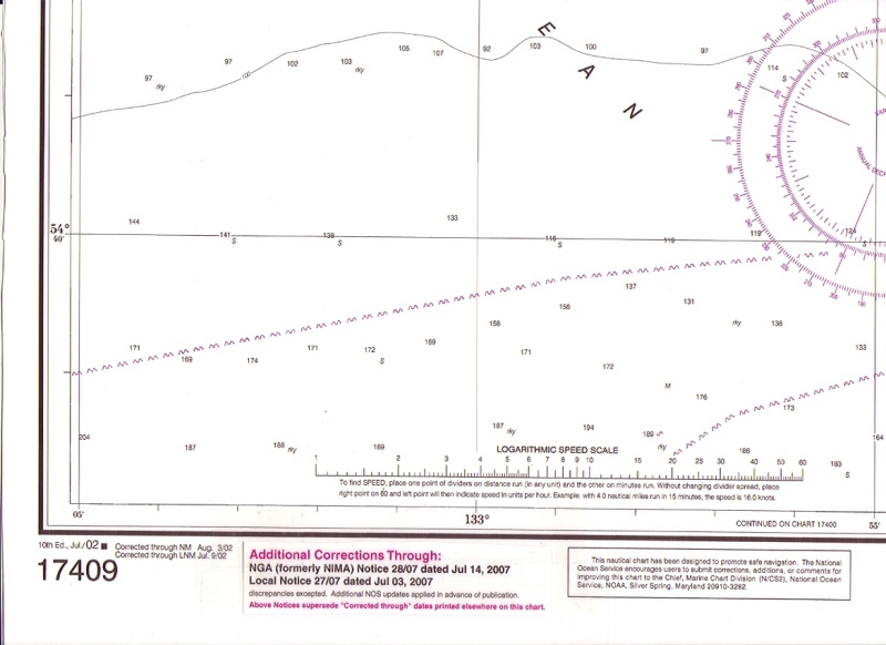
When raster charts are drawn, the finest line used is 1/2 milimeter wide. On an 80,000 to 1 scale chart that 1/2 mm line represents 120ft on the water. See Nigel Calders 'How to Read a Nautical Chart' book for a thorough discussion of charting and chart accuracy.
Basicaly, any chart, of any format, can only be as accurate as the source data. Paper charts have a legend showing when the surveys were made.
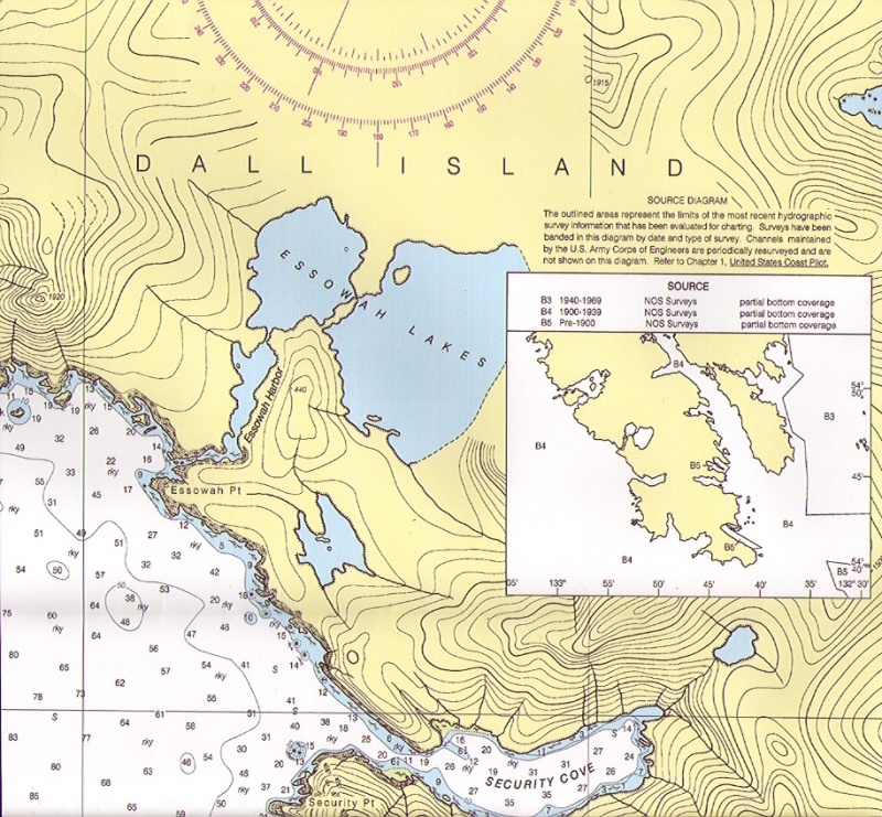
Here is a scan of a remote area in SE Alaska, and you can see how old the surveys are. The edition date of that chart is '02 with corrections applied thru '07.
Security Cove was charted from surveys done from 1900 to 1939, with only partial bottom coverage. No matter how good this chart looks in any format, its still just approximate.
While the rocks don't move, not all of them have been found yet!
 |
|
| Back to top |
|
|
journey on
Joined: 03 Mar 2005
Posts: 3598
City/Region: Valley Centre
State or Province: CA
C-Dory Year: 2005
C-Dory Model: 25 Cruiser
Vessel Name: journey on
Photos: Journey On
|
| Posted: Sun Apr 11, 2010 11:31 am Post subject: |
|
|
Larry, those are good points and you're correct.
As to the data validity, if the survey isn't good, well, garbage in equals garbage out. We used a C-Map cartridge for the North Channel in Lake Huron, which is a pretty remote place. I checked various small features on the chart (using the boat's GPS position) versus reality, and I believe it was within 10 ft. I don't know how C-Map does that but I was impressed. Note that C-Map is not government data, but their own charting data. I'd love to know how they do that, since I believe they/everybody starts with government surveys. So the conclusion is that some charts are better than others.
As to the width of a line on a chart, that's independent of the data validity. And with a raster chart, that width scale never changes. With a ENC chart, the width of the line stays the same as you zoom in, so the apparent width decreases. And as there is more room on the ENC chart, more text and icons can be displayed for more information. As you zoom in on a raster chart, the data becomes more pixillated.
To be honest, I use raster charts, actually printed charts, when I want overall area configuration. When I'm navigating, I appreciate the vector charts in C-Map.
What I really want now is the NOBELTEC radar that plugs into a PC. For less that $2500, I'd have a 15" screen, navigation software, and a PC for non navigation tasks. Does anybody have this setup? Can one of those ATOM processor notebooks run navigation software?
Both Nobeltec (VNS MAX Pro Navigation Software) and C-Map are now owned by Jeppson, so my chips should be useable. It's a long term project, selling Judy, mounting the PC and getting the software. Anyway it's a thought.
Boris |
|
| Back to top |
|
|
timflan
Joined: 16 May 2006
Posts: 544
City/Region: Seattle
State or Province: WA
C-Dory Year: 2005
C-Dory Model: 22 Cruiser
Vessel Name: Two Lucky Fish +1
Photos: Two Lucky Fish
|
| Posted: Sun Apr 11, 2010 12:31 pm Post subject: |
|
|
| Larry H wrote: | | Tim, If I could ask, what was your choice? |
Coastal Explorer. Even if the charts weren't quite as good as some other app, the extremely intuitive UI would still be a winner. The fact that the chart presentations also happen to be among the best makes this a very simple choice.
Full disclosure: I'm not paid by Rose Point, but I do count those folks as friends, and they do give me free software to test. |
|
| Back to top |
|
|
Bess-C
Joined: 03 Nov 2003
Posts: 459
City/Region: Anacortes
State or Province: WA
C-Dory Year: 2003
C-Dory Model: 25 Cruiser
Vessel Name: Bess-C
Photos: Bess-C
|
| Posted: Sun Apr 11, 2010 1:38 pm Post subject: |
|
|
Well, I guess I can be a guinea pig on this front. Tomorrow will begin the install of a complete PC based system on Bessie. Some of you may have seen Big Bay Technologies at the boat shows. I drank the koolaid and will have their displays and pcs loaded with Coastal Explorer software. The system will include radar overlay, AIS, a 17" display at the lower helm and a removable 15" display at the upper helm.
I have CE loaded at home and have been learning it the last few weeks. I like it a lot. I do have some major trepidation over this decision. I went back and forth between this and a Garmin 4212 based system for several weeks before making the decision. I'll keep you posted on the learning curve and any issues that arise.
Lyle
_________________
Bess-C 25 C-Dory sold 6/09
Bessie 46 Westcoast 6/09
Baby Dory 14 C-Dory 3/11
17 Center Console C-Dory 10/16 |
|
| Back to top |
|
|
timflan
Joined: 16 May 2006
Posts: 544
City/Region: Seattle
State or Province: WA
C-Dory Year: 2005
C-Dory Model: 22 Cruiser
Vessel Name: Two Lucky Fish +1
Photos: Two Lucky Fish
|
| Posted: Sun Apr 11, 2010 2:35 pm Post subject: |
|
|
| Lyle, I want to see this in operation! You going to be at Friday Harbor? |
|
| Back to top |
|
|
Larry H
Joined: 02 Nov 2003
Posts: 2041
City/Region: Tulalip,
State or Province: WA
C-Dory Year: 1991
C-Dory Model: 22 Cruiser
Photos: Nancy H
|
| Posted: Sun Apr 11, 2010 2:40 pm Post subject: |
|
|
Lyle,
You are a step ahead of me on this. I have a new laptop computer with Coastal Explorer loaded in, charts installed, a USB GPS ready to be installed, and a Serial to USB adapter to feed the AIS data into the computer.
Please do keep us in the loop.
You may already know, but Rose Point has a forum for Coastal Explorer support.
Link: http://coastalexplorer.net/support/forum |
|
| Back to top |
|
|
timflan
Joined: 16 May 2006
Posts: 544
City/Region: Seattle
State or Province: WA
C-Dory Year: 2005
C-Dory Model: 22 Cruiser
Vessel Name: Two Lucky Fish +1
Photos: Two Lucky Fish
|
| Posted: Sun Apr 11, 2010 2:49 pm Post subject: |
|
|
I plug my Class B AIS into my laptop using a Kayspane serial-to-USB converter, and that provides my own location plus AIS data.
No radar, no depth sounder, no engine instrumentation. That's all on the installed Raymarine plotter.
Despite the admittedly rinky-dink installation I've got going, I'm pretty happy with it. I've got redundant GPS fixes on redundant chart plotters. One of these days, I might try to integrate things in some for coherent way! |
|
| Back to top |
|
|
journey on
Joined: 03 Mar 2005
Posts: 3598
City/Region: Valley Centre
State or Province: CA
C-Dory Year: 2005
C-Dory Model: 25 Cruiser
Vessel Name: journey on
Photos: Journey On
|
| Posted: Sun Apr 11, 2010 3:11 pm Post subject: |
|
|
Lyle, could you please answer a couple of questions?
First, what radar are you using? The only one I know that plugs into a PC is the Nobeltec, but I believe this is a Koden.
Second, you sound as if you had a choice of software. My understanding is that only a limited set of software will input the radar data. I understand that these would be Nobeltec or Coastal Explorer. Is this correct, and if not what is the truth?
Third, what other sensors did you have to install. Specifically what GPS and what heading sensor, and how do you input them into the computer?
And finally, what PCs did you use? Sounds like a desktop for the first station and a laptop for the second. Is that correct and how does the display go from the primary computer to the slave?
Finally how does this all fit into a C-25?
Boris |
|
| Back to top |
|
|
Larry H
Joined: 02 Nov 2003
Posts: 2041
City/Region: Tulalip,
State or Province: WA
C-Dory Year: 1991
C-Dory Model: 22 Cruiser
Photos: Nancy H
|
| Posted: Sun Apr 11, 2010 3:21 pm Post subject: |
|
|
Boris,
I'm sure Lyle will answer here, but we have both become Trawler-Brats.
Mine is a 37ft Puget Trawler and his is even larger! More room on the dash, and a flybridge too! |
|
| Back to top |
|
|
Bess-C
Joined: 03 Nov 2003
Posts: 459
City/Region: Anacortes
State or Province: WA
C-Dory Year: 2003
C-Dory Model: 25 Cruiser
Vessel Name: Bess-C
Photos: Bess-C
|
| Posted: Sun Apr 11, 2010 8:11 pm Post subject: |
|
|
Sorry that I did such a poor job of communication. I typed it just before I had to leave this morning, and didn't give all of the facts. As Larry said, this isn't going on a 25 CD. It is going on our Westcoast 46 which has a flybridge upper helm and a lower helm with plenty of room to mount a 17' monitor.
The system will have a shock mounted marinized mini PC loaded with Coastal Explorer, the two monitors I described, a 4 kw dome Koden Radar which is the only option with Coastal Explorer, a Furuno PC-500 heading sensor, a dedicated 600 watt Pure Sign inverter, an RF mouse, a video splitter box and a Mill-Tech Marine AIS Receiver.
I have an existing Navman GPS and chartplotter that I will leave on the boat as a redundant system. I will also carry a P.C. loaded with a backup copy of Coastal Explorer. I have an existing Garmin sounder and transducer that I will use. I will not be able to put that sounder picture on the monitors, but it will give a depth reading to the system.
I am not doing the installation myself, it is being done by a professional installer. I will be at the boat on Friday to see the finished product and get a run through.
I was hoping to be at the Friday Harbor gathering. As of now it looks pretty unlikely that I'll be able to make it. We're going to try to get to Bellingham to see our C-Brat friends. I'll be glad to give a demo to anyone that we are able to meet up with.
Lyle |
|
| Back to top |
|
|
Bess-C
Joined: 03 Nov 2003
Posts: 459
City/Region: Anacortes
State or Province: WA
C-Dory Year: 2003
C-Dory Model: 25 Cruiser
Vessel Name: Bess-C
Photos: Bess-C
|
| Posted: Wed Sep 22, 2010 4:05 pm Post subject: |
|
|
I just spent 18 days on the boat, so I wanted to bring this subject up again and give a report on the electronics that I installed this year.
As I explained in a previous post, I installed a PC based system that I bought from Big Bay Technologies. The charting software is Coastal Explorer from Rosepoint. We have a mini computer installed under the lower helm, a 15" monitor at the lower helm and a 17" monitor on a ram mount at the upper helm.
The more I use the Coastal Explorer software, the more that I like it. It's intuitive, easy to use and flexible. It allows you to change chart types, quickly zoom in and out with the mouse, get immediate tide and current data and change radar settings easily on the fly.
The PC has Windows 7 installed and that worked with few problems. An occasional glitch on start up, but never failed or had problems when underway.
I had an AIS receiver installed and it added a great safety factor. We could see the ferries coming around tight corners and commercial traffic when crossing the shipping lanes. We had a couple of very foggy days and felt safe with the radar and AIS both working well.
The radar was the biggest surprise. My previous experience with radar was a 2kw Raymarine dome. The Coastal Explorer software only works with Koden radar. I had no knowledge or experience with Koden, so I was concerned about how the radar would work. We put on the Koden 4 kw dome and it is fantastic. I had the signal overlaid on the chart and it was much better than my previous radar. Coastal Explorer allows for easy changes to the radar settings.
Overall I would recommend the system. I thought AIS was kind of overkill before I had it, but after living with it for a couple of weeks I wouldn't want to be without it. It is very cheap extra insurance.
Lyle |
|
| Back to top |
|
|
|
|
You cannot post new topics in this forum
You cannot reply to topics in this forum
You cannot edit your posts in this forum
You cannot delete your posts in this forum
You cannot vote in polls in this forum
You cannot attach files in this forum
You cannot download files in this forum
|
|
 Search
 Private Messages
 Profile
 Log in
 Register
 Help
Help
