| View previous topic :: View next topic |
| Author |
Message |
rich&judym
Joined: 16 Nov 2008
Posts: 26
City/Region: Byron
State or Province: IL
C-Dory Year: 2012
C-Dory Model: 25 Cruiser
Vessel Name: Y-Knot
Photos: Y-Knot
|
 Posted: Sat Mar 20, 2010 10:12 am Post subject: Sandpiper's Horseshoe Loop Plans Posted: Sat Mar 20, 2010 10:12 am Post subject: Sandpiper's Horseshoe Loop Plans |
 |
|
After a winter of planning the Sandpiper and crew are headed Alabama way to cruise the Horseshoe. We will begin in Eufaula, Al. and end up in Montgomery Al. approximately three weeks later. This is a cruise route we discovered on El and Bill's Halcyon Days web site and thought it would be a good spring time cruise. We have been checking the weather and river reports and hope they cooperate. We will be joined by the Pelican from Putnum, Il. Plan is to leave after Easter. The route up from Mobile Bay will include the Blakely, Tensaw and Mobile Rivers until we hit the Alabama River and continue to Montgomery. Will carry 55-gals. of fuel to make it to Millers Ferry Marina, 180-miles from Mobile. Have USACE photo maps, NOAA charts of the Gulf ICW and cruising guides. If any C-brats have recent knowledge of the areas we would appreciate your input.
Rich, Judy and Molly Dog |
|
| Back to top |
|
 |
El and Bill
Joined: 08 Nov 2003
Posts: 3200
City/Region: Lakewood, CO
State or Province: CO
C-Dory Year: 2000
C-Dory Model: 22 Cruiser
Vessel Name: Halcyon
Photos: Halcyon
|
| Posted: Sat Mar 20, 2010 12:26 pm Post subject: |
|
|
Have a great trip, folks. We'll be thinking of Sandpiper - put up some posts so we can see how your cruise is going. You'll be in some beautiful country at a wonderful time of year. Bon voyage!
_________________
El and Bill (former live-aboards)
Halcyon 2000 CD 22 Bought 2000 Sold 2012
http://cruisingamerica-halcyondays.com/ |
|
| Back to top |
|
|
Byrdman
Joined: 06 Nov 2003
Posts: 3329
City/Region: Cumberland River, Clarksville,
State or Province: WA
Vessel Name: " ? " After Rename Ceremony
Photos: FreeByrd and C-Byrd
|
| Posted: Wed Mar 24, 2010 2:19 am Post subject: |
|
|
You should have a blast! But, I would call Millers to make sure how they are. Have a friend who lives on the AL river, down river side of the Selma Lock & Dam. He reported the highest water levels in 15-20 years last week....prior to the latest rains. More than likely a Corp site that you can see/monitor the water levels ...and, it just may be worth looking in to. Also, you may want to get a pre-filter as to run the fuel from Millers into your tanks...or, find out where their fuel is stored. High waters, not yet spring time for new fuel loads may also be some questions to ask. I think when we got Halcyon back up into Montgomery...there were some quality fuel issues. You should be fine with the fuel you take on in the Mobile area. But, up the Alabama River.... you will spend a lot of time all alone. Great trip.
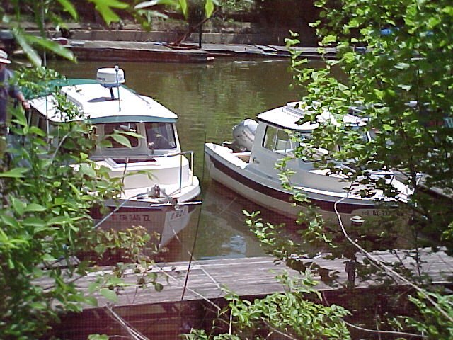
Pic below of Halcyon and Jabez docked out in Montgomery Marina after Halcyon completed the shoe. Great time.
Byrdman[/img]
_________________
Patrick Byrd "Byrdman"
Cumberland River TN home waters Puget Sound Summers.
Miss B - CD22A, Aug 2018
C-Byrd, CD18A, Hull #14 sold again.. May 2020
C-Byrd, CD18A, Hu #14 - Bought her again - May16
Aloysius, Sold to Brother Mike Mar16
Aloysius, Hull # 440 RF-246
C-Byrd, CD18A, Hull #14 Sold May09
TC24, Hull #51, Sold Feb06
CD16A, Sold Dec03
Never Deny Yourself The Pleasure of Helping Others. |
|
| Back to top |
|
|
thataway
Joined: 02 Nov 2003
Posts: 21468
City/Region: Pensacola
State or Province: FL
C-Dory Year: 2007
C-Dory Model: 25 Cruiser
Vessel Name: thataway
Photos: Thataway
|
| Posted: Sun Mar 28, 2010 6:40 pm Post subject: |
|
|
I would check to see if you will have to jerry can fuel at Miller's ferry. Spring run offs bring deeper water (generally not a problem), but also higher currents.
_________________
Bob Austin
Thataway
Thataway (Ex Seaweed) 2007 25 C Dory May 2018 to Oct. 2021
Thisaway 2006 22' CDory November 2011 to May 2018
Caracal 18 140 Suzuki 2007 to present
Thataway TomCat 255 150 Suzukis June 2006 thru August 2011
C Pelican; 1992, 22 Cruiser, 2002 thru 2006
Frequent Sea; 2003 C D 25, 2007 thru 2009
KA6PKB
Home port: Pensacola FL |
|
| Back to top |
|
|
rich&judym
Joined: 16 Nov 2008
Posts: 26
City/Region: Byron
State or Province: IL
C-Dory Year: 2012
C-Dory Model: 25 Cruiser
Vessel Name: Y-Knot
Photos: Y-Knot
|
| Posted: Mon Mar 29, 2010 9:35 am Post subject: |
|
|
El and Bill,
Thanks for the words of encouragement.
Byrdman and thataway,
Thanks for the heads up on the fuel at Millers Ferry. I talked to them and they said the river had been high but was receding and the trash and the current on the river have gotten better. I will touch base with them prior to leaving Mobile Bay. If the conditions are not favorable, we can either stop at Mobile or possibly go up the Tenn Tom north bound. At this time the NOAA river stages are showing all green except for Blountstown on the Apalachicola river, meaning no flooding. Have been on the upper Miss. River during high water, and made it. Just have to be careful.
Rich, Judy and Molly Dog |
|
| Back to top |
|
|
Pat Anderson
Joined: 02 Nov 2003
Posts: 8556
City/Region: Birch Bay, WA
State or Province: WA
C-Dory Year: 2005
C-Dory Model: 25 Cruiser
Vessel Name: Daydream
Photos: Daydream and Crabby Lou
|
| Posted: Mon Mar 29, 2010 3:54 pm Post subject: |
|
|
OK, I'll bite! Googled "Horseshoe Loop map" and got a lot of stuff, but notA route for a cruise! Can somebody put up a map of where this cruise takes you? JIM - NONE OF YOUR PHONEY-BALONEY MAPS EITHER!!!!
_________________
DAYDREAM - CD25 Cruiser
CRABBY LOU - CD16 Angler (sold 2020)
Pat & Patty Anderson, C-Brat #62!
http://daydreamsloop.blogspot.com

|
|
| Back to top |
|
|
Pat Anderson
Joined: 02 Nov 2003
Posts: 8556
City/Region: Birch Bay, WA
State or Province: WA
C-Dory Year: 2005
C-Dory Model: 25 Cruiser
Vessel Name: Daydream
Photos: Daydream and Crabby Lou
|
| Posted: Mon Mar 29, 2010 4:35 pm Post subject: |
|
|
For the newcomers, I once led with my jaw and asked Jim for a map of his route on the Trent-Severn...
Still one of the funnier things on this site... |
|
| Back to top |
|
|
thataway
Joined: 02 Nov 2003
Posts: 21468
City/Region: Pensacola
State or Province: FL
C-Dory Year: 2007
C-Dory Model: 25 Cruiser
Vessel Name: thataway
Photos: Thataway
|
| Posted: Mon Mar 29, 2010 5:19 pm Post subject: |
|
|
I don't have a map, but the route starts in Alabama/Georgia State line at Eufaula, (You can start further North if yo want at Columbus or La Grange Georgia). You go down the Chattachoochee river South Bound along the Ga, Al border, into Florida to Lake Seminole. Then down the Apalachicola River, and to the Gulf Coast inter Coastal waterway. Thus East bound to Mobile Bay, and basically up the Mobile River to the Alabama River, as far as Montgomery. The Tensaw and Bradley rivers are a bit of a red herring--the most direct and easiest route is up the Mobile River. I have been to many of these places in my RV in the last few weeks. The run off depends a lot on how much rain we have in the South.
So far the Alabama River has been semi maintained as a commercial waterway, although there is minimal barge traffic. Thus no real marinas along the route until you get to Montgomery. The distance from fuel in Mobile to fuel in Montgomery is some where close to 300 miles. Miller's ferry is a landing and park where there is a small (and basically the only) marina in this river section. There are 3 locks and dams which must be transversed. A question in my mind is if these locks will be continued to be maintained and manned, due to the low volume of traffic. The trip is a way to see very rural Alabama and some of Florida--some places that time seems to have forgotten. |
|
| Back to top |
|
|
El and Bill
Joined: 08 Nov 2003
Posts: 3200
City/Region: Lakewood, CO
State or Province: CO
C-Dory Year: 2000
C-Dory Model: 22 Cruiser
Vessel Name: Halcyon
Photos: Halcyon
|
|
| Back to top |
|
|
BrentB
Joined: 15 Jul 2006
Posts: 4420
City/Region: Greenwood
State or Province: IN
Photos: BrentB
|
| Posted: Mon Mar 29, 2010 11:22 pm Post subject: |
|
|
Jim
Please post a map with a legend, POI and doodads

_________________
Brent Barrett |
|
| Back to top |
|
|
El and Bill
Joined: 08 Nov 2003
Posts: 3200
City/Region: Lakewood, CO
State or Province: CO
C-Dory Year: 2000
C-Dory Model: 22 Cruiser
Vessel Name: Halcyon
Photos: Halcyon
|
| Posted: Tue Mar 30, 2010 1:00 pm Post subject: |
|
|
| An easy way to visualize the route - south down the eastern border of Alabama, then westerly along the southern border of the state along the Gulf to Mobile, then northeast to the center of Alabama - all on water. Great state for boating! |
|
| Back to top |
|
|
El and Bill
Joined: 08 Nov 2003
Posts: 3200
City/Region: Lakewood, CO
State or Province: CO
C-Dory Year: 2000
C-Dory Model: 22 Cruiser
Vessel Name: Halcyon
Photos: Halcyon
|
| Posted: Tue Mar 30, 2010 1:01 pm Post subject: |
|
|
| An easy way to visualize the route - south down the eastern border of Alabama, then westerly along the southern border of the state along the Gulf to Mobile, then northeast to the center of Alabama - all on water. Great state for boating! |
|
| Back to top |
|
|
BrentB
Joined: 15 Jul 2006
Posts: 4420
City/Region: Greenwood
State or Province: IN
Photos: BrentB
|
| Posted: Tue Mar 30, 2010 2:20 pm Post subject: |
|
|
I was hoping for a Rube Goldberg type of a map from Jim.
I attended Purdue the RG contest was a major event for the engineering students |
|
| Back to top |
|
|
rich&judym
Joined: 16 Nov 2008
Posts: 26
City/Region: Byron
State or Province: IL
C-Dory Year: 2012
C-Dory Model: 25 Cruiser
Vessel Name: Y-Knot
Photos: Y-Knot
|
| Posted: Fri May 07, 2010 12:54 pm Post subject: Sandpiper's Horseshoe Loop Completed |
|
|
Sandpiper and crew left Eufaula, Al. on April 7th and completed the cruise on April 19th. in Montgomery, Al. Weather was excellent all the way. Met a bunch of fine folks everywhere we stopped. A few pictures are posted in our photo album. Headed out next week on the Miss. River for some fishing and to the Apostle Islands after the 4th of July.
Rich & Judy |
|
| Back to top |
|
|
|
 Search
 Private Messages
 Profile
 Log in
 Register
 Help
Help
